
Over the past 50 years, American and Soviet spacecraft have produced a wealth of information about Mars. Photomosaics of the entire planet have been made, topographic and surface relief maps have been published and geologic maps compiled in a variety of scales. Small robotic geologists have rolled across the surface taking pictures and analyzing rocks. Moreover, we may also have pieces of Mars here on Earth, delivered free of charge as small meteorites. Consequently, our understanding of the planet generations of humans thought to be most like Earth, has increased dramatically. Compared to the landforms on the Moon or Mercury, the surface features of Mars have origins more diverse and complex. Almost everything on Mars is not only big but gigantic. Impact shaped about half the surface; the largest crater is about twice the size of the largest crater on the Moon. Other areas have been formed by volcanic activity, with some volcanic shields reaching more than 20 kilometers above the surrounding surface. The largest volcano on Mars has ten times more volume than the largest volcano on Earth. Mars even has a tenuous atmosphere and bright polar caps. Photographs show the details of advancing and retreating frost shrouds. Wind action is a major geologic process, and moving sand and dust altered many features on the planet. To the surprise of all, ancient channels are found on the surface; these appear to have been formed by running water. Tectonic movements fractured parts of the planet and produced a great canyon system which has been enlarged by erosion. It is apparent that the geologic agents operating on Mars not only differed from place to place, but also varied throughout the planet's long history. Because it is larger than the asteroids, the Moon, and Mercury, Mars provides another reference point in the progression of planet size for understanding the fundamental principles of how and why the planets evolve.
The planet Mars has fascinated observers for many centuries, partly because of its distinctive red glow but also because it is so near Earth. Indeed, many of its physical characteristics suggested that Mars might even harbor life. Fortuitously, the rotational axis of Mars currently tilts almost exactly the same amount as Earth's, causing cyclical season changes (which last about twice as long on Mars, because of its longer period of revolution about the Sun). Polar caps of carbon dioxide and water ice advance and retreat in response to the temperature changes. (Some imaginative scientists early in the twentieth century suggested that the color changes accompanying the season changes showed that plant life existed on the surface, advancing like a front toward the poles as each spring brought warmer temperatures.) Mars also possesses a thin atmosphere composed mainly of carbon dioxide. Nitrogen, oxygen, and a seasonally variable amount of water are also present in the atmosphere. The water-vapor content is much less than that in the air over terrestrial deserts. Tenuous clouds and migrating storms indicate that Earth-like processes occur within the atmosphere. Although temperatures are generally below freezing and the atmospheric pressure is a hundred times lower than that on Earth, the fourth planet from the Sun seems hospitable compared to the airless Moon or the searing heat on Mercury.
Mars is a fairly small planet, larger in diameter than Mercury or the Moon, but smaller and less massive than Earth (one-tenth mass of the Earth). The gravitational force exerted on objects near the surface is slightly more than one-third of Earth's constant tug and about the same as Mercury's. At 24 hours and 37 minutes, the martian day is only a bit longer than a day on Earth. Mars has two natural satellites. These tiny moons, called Phobos (about 20 km across) and Deimos (only 10 km across), are the size of small asteroids and will be described in Chapter 8.
Geologically, Mars is vastly different from Earth in spite of some outward similarities mentioned above. It is an "intermediate" planet, with an array of Moonlike, Earthlike, and uniquely martian features, which we will examine closer.
The surface of Mars was completely photographed during the epic flight of Mariner 9 in 1971 and 1972. Subsequently, remarkably detailed photographs were obtained by the orbiting satellites of the Viking mission, which operated from 1976 to 1980. From these data, topographic and geologic maps of the whole planet have been made and an intriguing, increasingly complex interpretation of the martian surface is developing.
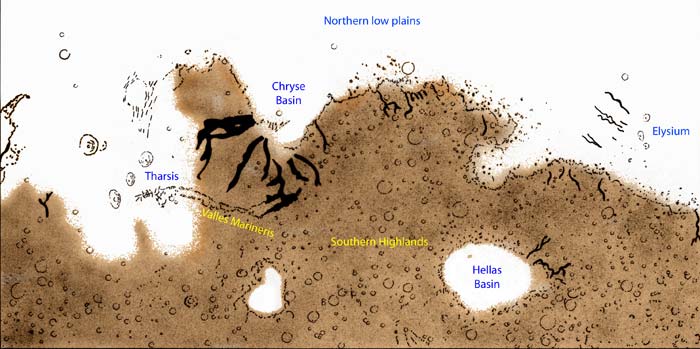
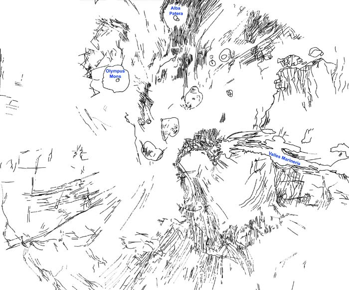
The generalized geologic map of Mars (Figure 6.1) shows the location of the major provinces and the distribution of the important terrain types. The surface of Mars may be divided into two major geologic provinces: (1) the old, densely cratered terrain in the south; and (2) the low, young, sparsely cratered plains in the north. The boundary separating the two almost coincides with a great circle inclined at 35 degrees to the equator. These landforms in these major provinces were modified by a surprising variety of surface and internal processes to produce terrain types not seen on the Moon or Mercury.
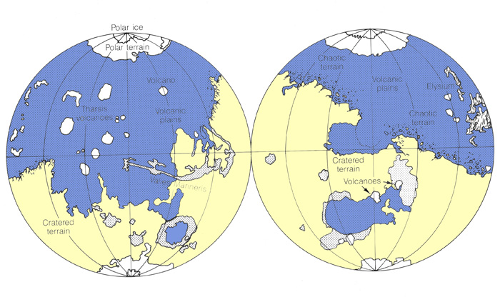
The densely cratered terrain in the southern hemisphere of Mars is a highland somewhat like the ancient cratered terrain of Mercury or the highlands of the Moon, where craters of all sizes and shapes dominate the landscape. Several huge multiring basins, larger than Imbrium or Caloris, are the major features in parts of the highlands. Elevations are generally in excess of 1 km above the mean martian radius except in the smooth interiors of Hellas and Argyre basins. Much of the martian cratered terrain contains large areas of relatively smooth intercrater plains and a few old shield volcanoes.
Although the nature of the intercrater plains on Mercury is still in question, some martian plains are definitely volcanic. Some large channels that appear to have been carved by rivers or huge floods cross this ancient battered surface as well, giving it a decidedly nonlunar appearance.
The low plains in the northern hemisphere are separated from the southern highlands by a prominent cliff that is 2 to 3 km high in places. If Mars had an ocean 2.5 km deep, the ocean would cover the northern plains and leave most of the heavily cratered terrain high and dry as one huge landmass. The brightness of the plains is highly variable, reflecting the diverse origins of the different smooth surfaces. Photographs of this area show prominent mare-type lava flows, small lava or cinder cones, and ridges, all indicative of a volcanic origin. Dunes and wind streaks formed behind topographic obstacles attest to eolian (wind) modification and blanketing of large tracts. Since many of the major channel systems empty into basins in the north, stream sediments may be interlayered with the other deposits. It was in this area of complicated geology that the two Viking landers touched down.
Two continent-sized domical highs or upwarps capped with huge shield volcanoes are located in the northern hemisphere near the escarpment. The largest is in the Tharsis region of the western hemisphere, where the volcanic field appears to sit astride the global escarpment. The smaller field, Elysium, is located well within the northern plains of the eastern hemisphere.
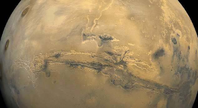
The large structural dome in the Tharsis region has created a system of radial fractures that extend nearly halfway around the globe. Faulting and erosion along an east-west segment of the fracture system has developed Valles Marineris, the "Grand Canyon of Mars," which extends from the fractured bulge near Tharsis across the cratered plains, and breaks into several north trending channels near the escarpment.
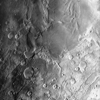
The ultimate origin of the scarp separating the two physiographic provinces is still unknown. It is well defined in the eastern hemisphere but is masked in the west by lava flows from the Tharsis volcanoes. The escarpment is an erosional contact between the younger northern plains and the ancient cratered highlands in the south. It has been dissected by various types of stream erosion and mass movement that are unique to Mars. This erosion gradually forced the margin of the highlands to retreat southward. In places the cratered highlands south of the escarpment are fractured and modified by slumping. This landscape is accentuated as the scarp is approached, so that only chaotic masses of angular blocks, or mesas, are left standing above the plain--- creating a fantastic landscape called the fretted terrain. Farther into the plains, only small, rounded knobs are left; these eventually disappear to the north. Some major channels arise in this complexly eroded transition zone and modify the global escarpment.
The bright polar caps of Mars were first identified from Earth with the use of telescopes. Large permanent caps of water ice are located at each pole. The caps rest on a sequence of layered sedimentary deposits. Carbon dioxide ice is present at least temporarily at both poles. Revealing the power of the atmospheric circulation, sections of the surrounding terrain have been pitted and etched by wind-related erosional processes, and a discontinuous ring of dunes surrounds much of the northern cap photographed during the Viking mission.
Certainly one of the most important accomplishments during the last two decades of space exploration was the soft landing of a pair of spindly Viking spacecraft on Mars in 1976. The landers performed amazingly well and returned panoramic vistas of boulder-strewn plains from two widely separated spots on the planet, as well as chemical analyses of the regolith. Although both sites appear superficially the same, there are some significant differences. The sites were chosen because of their smoothness as seen from orbit and because of the strong indications that water may be present in the soil. They thus do not show us a view of the more spectacular landscapes of Mars found elsewhere.
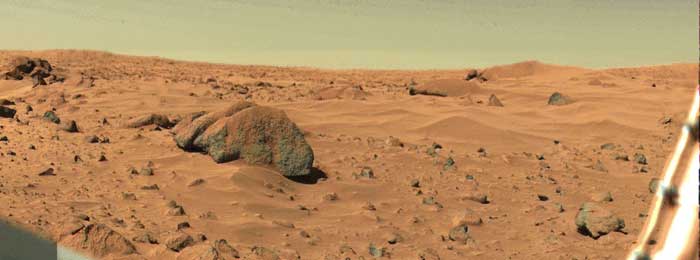
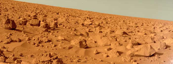
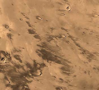
Viking 1 landed in a low, smooth basin in the northern hemisphere several hundred kilometers from the global escarpment. Several large channels that drained water from the highlands to the west and south flow into Chryse Planitia (Gold Plain), and it was thought that water from them might have helped to support some sort of biological activity. The cameras on Viking 1 showed a dusty, orange-red surface strewn with boulders of all sizes and shapes (Figure 6.2). Drifts of windblown sand have collected behind and on top of many rocks; the wind has also fluted some pebbles and scoured away the sand to expose the light-colored bedrock beneath the soil.
One striking feature photographed by the lander is the bright sky (Figure 6.2). The Moon, because it has no atmosphere, has no sky and is surrounded only by dark space. The martian sky has a reddish tint imparted by dust particles suspended in the thin, carbon dioxide atmosphere. The dust may be red because of the oxidation of iron-rich minerals in the soil---a process similar to rusting
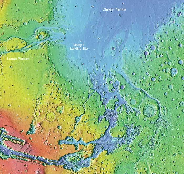
Chryse Basin is a shallow sediment- and lava-filled trough. Although no impact craters occur near the spacecraft, several appear on the horizon, and views from orbit show that large channels extend to within about 60 km of the landing site. The history of the area probably began with the formation of a densely cratered surface that was later covered with lava flows. Channel formation along the borders of the basin may have flooded the area and deposited sediments eroded from the highlands to produce the rubbly landscape. Subsequent light bombardment and continual eolian modification have rendered further changes.
Far to the north, on the other side of Mars, Viking 2 set down about a month after its sister spacecraft, in Utopia Planitia. In spite of the low temperatures, abundant water vapor had been detected from orbit. During the summer days temperatures hovered at about -10 °C (260 K) and the low at night reached a frigid -50 °C (220 K). The photos returned from Utopia show an orange-red plain littered with porous, spongelike rocks, similar to some terrestrial volcanic rocks (Figure 6.3). Drifts of sand and wind-shaped cobbles and boulders are not as common here as on the Chryse plain. A polygonal system of troughs that is not seen at the other landing site developed in the soil. The troughs may have formed as ice wedges in the soil, cracked it, and formed shallow linear depressions on the surface.
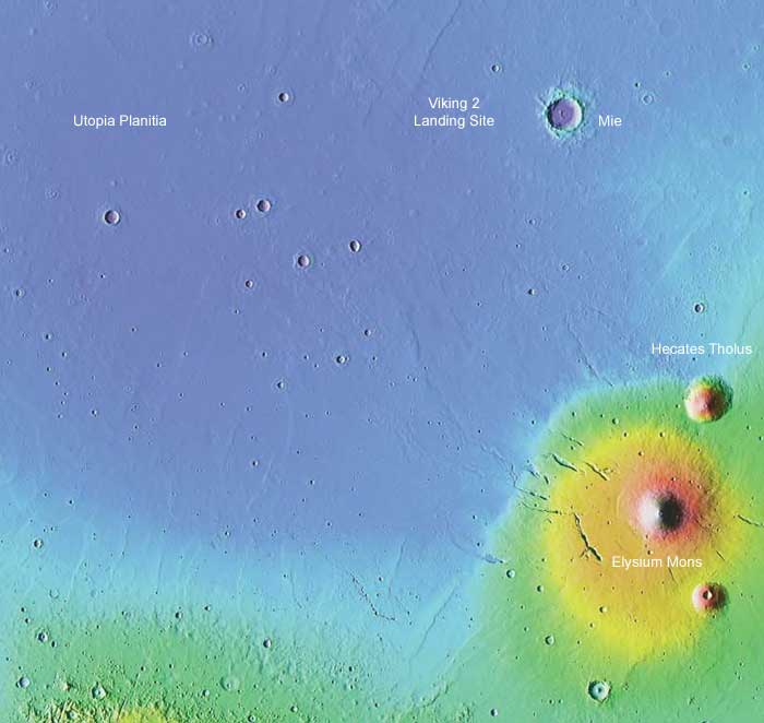
The view from orbit shows that Utopia Planitia is a relatively smooth plain, locally dotted with low volcanic domes and small craters. The crater frequency is lower here than at Chryse and must represent a younger surface. The simplest history of the area maintains that Viking 2 landed on the far edge of an ejecta blanket formed when the crater called Mie was excavated. Other theories hold that the rubbly surface was shaped by massive floods or as debris was dropped by a formerly more extensive ice cap.
Using various instruments the Viking landers alternately poked, prodded, scooped, hammered, cooked, and analyzed the martian soil, determining its composition and physical characteristics and trying to find out if it contained any evidence of life. Although no unambiguous signs of martian biota were found, we now know much more about the chemistry of martian soil. Comparison with terrestrial materials indicates that the martian soil may have originated from hydration or alteration of iron-rich basaltic rocks, consistent with the hints of volcanism in both areas.
The recent conclusion that a few meteorites are samples of Mars blasted away by a low angle impact, opens a new door for our exploration of Mars. We discussed these meteorites briefly in Chapter 3. These SNC meteorites (short for Shergotty, Nakhla, and Chassigny) are igneous rocks with basaltic compositions very similar to that found by the landers and rovers. The gases trapped within them have the same composition as that of the martian atmosphere as analyzed by several spacecraft. Their ages (some are 1.3 billion years old) are extremely young for any asteroid and suggest that they must have formed on a large planet that cooled slowly and had a long volcanic history. Their compositions tell us that there is significant water in the martian interior and at the surface; the abundances of moderately volatile elements like potassium suggest that Mars has a larger endowment of volatiles than Earth itself. And their ages give us a few punctuation points for the long martian history.
We have seen in previous discussions that both the Moon and Mercury have differentiated interiors made up of shells with different chemical compositions. Unfortunately the Viking landers did not detect "marsquakes" strong enough to precisely define the thickness of the various shells, but much has been inferred about their nature by variations in the gravity field, comparison with better understood planets, and calculations to predict the thermal evolution of the martian interior (Figure 6.4).
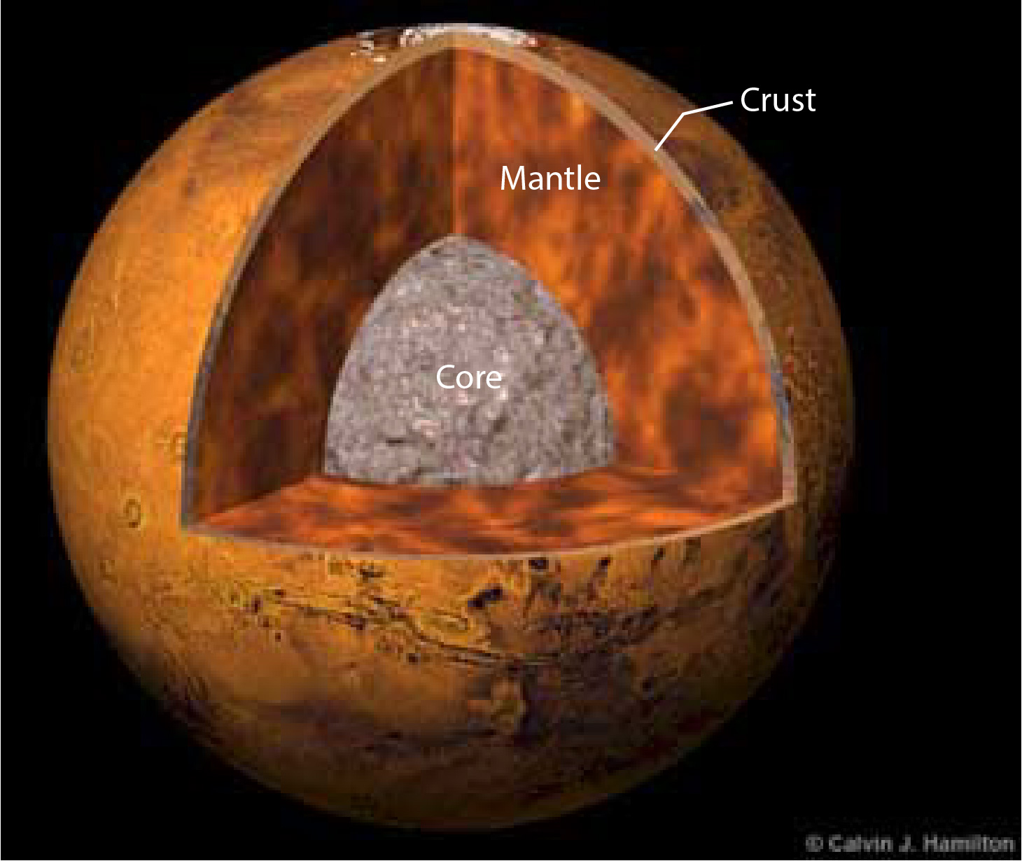
Mars is larger in diameter than Mercury and about twice as massive, but it has a lower bulk density (3.93 g/cm3). Apparently, Mars is composed of lighter materials than Mercury (5.44 g/cm3), which is consistent with nebular condensation models that predict significant incorporation of light volatile materials (water for example) in Mars that did not condense where Mercury formed. This compositional implication and its larger size, and consequently a greater ability to retain heat, lead one to suspect that the internal structure of Mars may be more like that of Earth than that of the Moon or Mercury.
Theoretical models of the interior structure predict just such a situation (Figure 6.4). Mariner 9 returned data that demonstrated that there is a significant density contrast between the shallow layers of Mars and its deep interior, including evidence for a core. The radius of the core is probably about 1500 to 2000 km. It is not composed just of iron but probably contains some sulfur or oxygen, which lowers its density. The SNC meteorites are also depleted in elements that have an affinity for sulfur; we speculate that these elements were removed into the sulfur-rich core by differentiation. Several Mars probes have shown that the martian magnetic field is so small it is basically nonexistent. This is somewhat surprising in that Mars is larger than Mercury and presumably warmer, with a convecting core. It also spins much faster on its axis. Both features should create a stronger magnetic dynamo for Mars, and yet Mercury has a magnetic field and Mars does not. Perhaps, the martian core is completely solidified now, after eons of cooling. The larger size of the mercurian core, a unique composition, or tidal energy inputs may have kept it molten and convecting for much longer than the Moon.
The bulk of the mass of Mars probably lies in a thick silicate mantle about 1300 to 1800 km thick. It is very likely that the interior is still actively convecting, which may have created forces that tectonically deformed the crust. Moreover, some models of the thermal evolution of Mars predict that a thin layer within the mantle could still be partially molten and might serve as a source for active volcanism at the surface. This ductile asthenosphere probably occurs at a depth of about 250 km and marks the base of the overlying rigid lithosphere. The lithospheres of the Moon and Mercury are probably much thicker (1000 km and 600 km respectively); and partial melt zones, if they occur at all, are very near the compositional boundary between mantle and core in these other planets.
The martian lithosphere is probably composed of two units: the upper mantle just described, and the crust formed during the primordial differentiation of the planet. From comparisons with the Moon, the crust is thought to be rich in alumino-silicate minerals and very thin compared to the mantle. The thickness of the Moon's crust varies from 60 to 100 km and Earth's varies from 5 to 80 km, with an average thickness in the range 30 to 35 km. Analysis of the gravity field of Mars indicates that its crust averages 25 to 40 km thick and that it is probably thinner in the northern hemisphere. The crust may reach a maximum of around 70 km under the high Tharsis plateau; however, some models suggest a very thin crust or lithosphere beneath Tharsis. Resolution of this problem awaits further investigation.
Internal differentiation of a planet is thought to occur when the planet partially melts from either accretionary heat or radioactive decay early in its history. As rocks melt, gases and vapors are usually released first and, because they are much lighter, rise rapidly to the surface. The presence of volatiles and the relatively large gravity field of Mars has enabled the planet to retain a tenuous outer shell of such gases. A planet's atmosphere may be considered to be its outer layer, an important part of its structure. The martian atmosphere is thin, exerting a pressure of only about 0.01 that of Earth's atmosphere, and composed mainly of carbon dioxide; but it has played a very significant part in the geologic evolution of Mars.
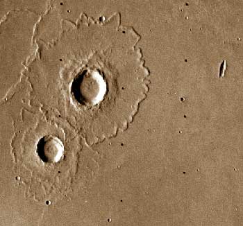
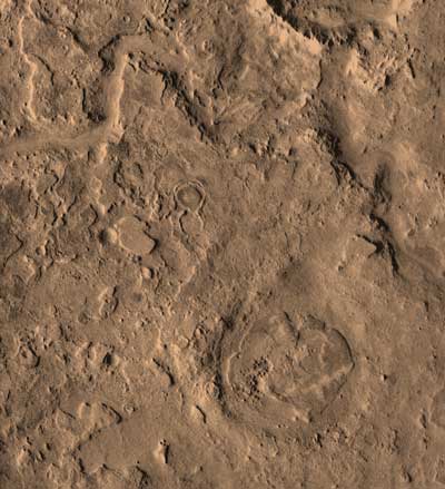
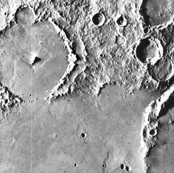
Although the photographs from recent space missions have revealed a far greater variety of landforms on the surface of Mars than were seen on the Moon or Mercury, cratering still appears to have been the dominant process in shaping the surface of Mars, especially during the early history of the planet. The craters on Mars have many distinctive features, however, which reflect the gravitational attraction, surface processes, and erosional history of the planet. Many craters are shallow, flat-floored depressions that show evidence of much more erosion and modification by sedimentation than do those on Mercury or the Moon. Rayed craters are rare, but fresh craters do occur and are unique in that some are surrounded by lobate scarps, indicating that the ejecta may have moved like a mudflow after it fell to the surface (Figure 6.5).
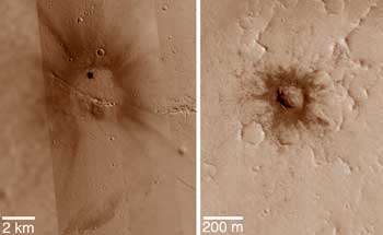
The morphology of crater ejecta on Mars is unique. Ejecta blankets of lunar craters are usually blocky near the rim and grade outward to finer particle sizes until the blanket merges imperceptibly with fields of secondary craters and rays. All of these features are consistent with the ballistic emplacement of the ejecta. Many martian craters, in contrast, have ejecta deposits that appear to have flowed over the surface like mudflows, and lack the delicate rays seen around craters on other planetary objects. The continuous ejecta deposit commonly extends from 1.5 to 2 times the radius of the crater---on the Moon this value is only about 0.7 and on Mercury (which has a gravity similar to Mars) only about 0.5. Apparently, the ejecta from those martian craters became fluidized in some fashion, allowing it to flow long distances after excavation. These craters are called rampart craters, fluidized craters, or splash craters.
A spectacular example of a rampart crater is the 18-km-diameter crater named Yuty shown in Figure 6.6. The ejecta consists of several relatively thin layers or sheets of material with tongue-shaped projections. It appears that the debris flowed outward like huge splashes of mud that surged outward when they hit the ground. A prominent ridge was produced at the front of each ejecta lobe. To the right, the ejecta flow overlaps an older degraded remnant of a larger crater and actually moved up and over the wall formed on the eroded ejecta blanket. To the south, a smaller and older crater separates two large lobes on the surface of the ejecta, but was also filled with liquified debris. Liquid water may have been incorporated into the material as it was thrown out of the crater, creating a rapidly moving mudflow. The collision of the meteorite with the surface may have melted ice in the regolith and mixed the water with the ejecta.
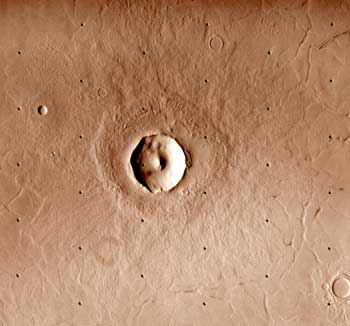
Craters with diameters less than 15 km usually have a single ejecta sheet (Figure 6.7) that only extends out to about one crater radius. The surface of the sheet is typically marked with many concentric ridges and ends abruptly at a ridge or escarpment. Locally, rays or fields of secondaries or hummocks related to the crater extend beyond the edge of the ejecta lobe. The ejecta sheet appears to be thicker and more viscous than those associated with Yuty-type craters. Terraces are present on the walls of many of these craters and are significantly displaced from the crest of the rim.
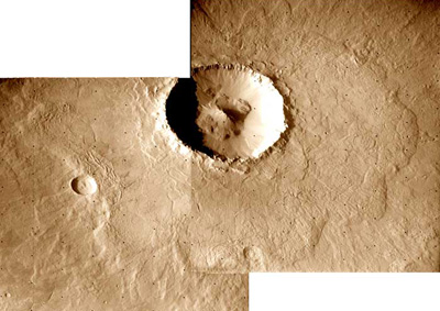
Another type of rampart crater, which has elements of both types described above, is shown in Figure 6.8. Like the two craters just described, it is surrounded by an annulus of thick ejecta with a patterned surface. However, unlike the previous craters, radial ridges are an important component of the pattern. Although an escarpment bounds this lobe, a distinct ridge is usually absent. Beneath and extending to greater distances are sets of thin lobate ejecta sheets similar to those around Yuty. Occasionally this outer set of lobes is missing, but this may be a result of modification of the primary landform.
Rampart craters commonly have large central peaks or pits, which may result from the explosive expansion of ice as it vaporizes during impact. Terraces are absent on the walls of some rampart craters. For example, in Arandas (Figure 6.8) only a small amount of material lies in a heap around a large central peak.
If rampart craters really are the result of the incorporation of water into ejecta, detailed studies of their distribution on the planet may eventually show regional variations in ground ice (or ground water) and the smallest craters that have fluidized ejecta patterns may reveal the depth to which water lies beneath the surface.
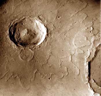
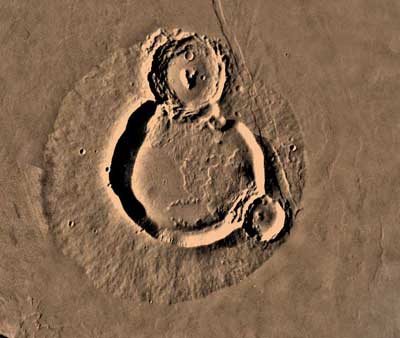
Over twenty large, circular basins that are similar to the multiring lunar basins such as Orientale and Imbrium have been discovered on Mars. Some of them are readily apparent on the geologic map (Figure 6.1) and, although they have been significantly modified by both erosion and deposition from processes unique to Mars, they are in many ways similar to their lunar counterparts (Figure 6.9). The largest martian basin is Hellas, which is almost 2000 km across, much larger than either Imbrium or Caloris. Several vaguely defined rings have been identified, but they are highly degraded and not continuous. Much of the basin is covered by plains, so parts of the inner rings may be buried by basalt or sediment. The northern and eastern rims of Hellas are composed of belts of rugged, peaked mountains that resemble the Apennine Mountains that form the rim of the Imbrium basin on the Moon. The high rim has probably been eroded and much of the material deposited in the center of the depression. Other large basins, like Isidis and Argyre, are modified by erosion and partly covered with a sedimentary blanket, but similarities between them and the lunar basins are great enough to support the conclusion that they, too, were formed by the collision of asteroid-size bodies with Mars.
The early period of intense bombardment and basin excavation is recorded primarily in the rugged southern highlands. The only way to estimate absolute ages on Mars is by comparison with the cratering record of the Moon. If this comparison is valid, the most intense cratering occurred from 4.5 to 3.9 billion years ago. The frequency of large impact basins on Mars (about 1 per 10 million km2) is much less than on the Moon (8 per 10 million km2) or Mercury (14 per 10 million km2). Even assuming that the processes that produced the northern plains destroyed half of the martian basins, Mars would still have a much lower frequency than the Moon. The progression in basin density from the Sun outward suggests that perhaps the numbers of large impactors decreased outward from the Sun during the early history of the solar system. However, even for smaller craters this heavily cratered region is not as densely cratered as the Moon, a sure indication that burial (by lavas or sediments) and substantial erosional modification obliterated some of the earliest traces of the planet's bombardment.
In contrast to the Moon and Mercury, Mars is not a dry planet. Volatile materials rich in water were probably incorporated in the planet during accretion. During differentiation these volatiles were partially outgassed and accumulated at the surface. Several arguments can be made for outgassing of the equivalent of a global ocean several hundred meters deep. Evidence for these ideas are the many channels, which closely resemble dry river beds on Earth. Many enormous channels originate in the southern highlands near the erosional escarpment and flow northward, emptying into the low plains. Other, smaller channels have furrowed much of the old highlands. If any of these channels had been seen on Earth, no one would hesitate to call them dry rivers, but their presence on Mars presents some most perplexing questions about the planet. With the present temperature and atmospheric pressure on Mars, water cannot exist for long in a liquid state at the surface; it either evaporates or is frozen. But the presence of river or fluvial channels shows that running water and even huge floods occurred in the past. When did liquid water exist, where did it come from, and where has it gone? These problems are not easy to solve and will continue to be discussed for some time.
Instruments on the Viking spacecraft showed that there are large quantities of water ice and vapor on Mars. Parts of the ice caps are water ice, and at night the martian atmosphere is saturated with water. Water is apparently also present in the pore spaces of rocks and soil. Most water in the martian hydrologic system is locked up as ice in the polar regions, as ground ice in frozen soils, or as ground water (liquid) at a depth of several hundred meters where the temperature is higher. A well-integrated hydrologic system composed of oceans and rivers (or their frozen equivalents---ice caps and glaciers) that transfers water back and forth between its components through evaporation, rainfall, and surface flow does not exist at present on Mars. However, the martian climate must have been very different at some time in its geologic past and a better-developed hydrologic system existed.
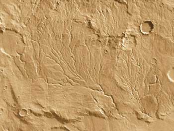
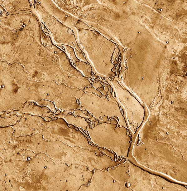
Perhaps the best evidence for the former existence of a hydrologic system on Mars comes from the networks of filamentous channels in the southern highlands. These channels or valleys show many characteristics of dendritic river systems on Earth (Figure 6.10). Many erode the rims of ancient craters or the slopes of volcanoes. Individual segments are commonly less than 50 km long and less than 1 km wide, but whole systems, consisting of many branching tributaries, may be up to 1000 km long. In some cases, they resemble stream networks that result from the collection of rainfall as it flowed down slopes. Deposits concentric to the rims of some large impact basins may be the remnants of deltas or alluvial fans where these rivers dropped the sand and gravel they were carrying into lakes or seas, but some valley systems end abruptly, with little evidence of a sedimentary deposit.
Crater frequencies on these valleys show that most are very old, and probably formed 3.5 to 4.5 billion years ago, during the heavy bombardment of Mars. During this early part of martian history, the atmosphere may have been denser and occasional warm periods, resulting from the greenhouse effect or orbitally induced climatic change, may have allowed rain to fall, collect in small streams, and dissect portions of the ancient terrain. Seas or oceans may have developed in the low northern plains or in deep impact basins. The formation of dendritic valleys seems to have ceased by the end of the heavy bombardment, suggesting that a persistent ocean, if it existed, disappeared by this time.
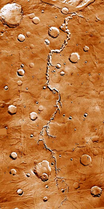
Although this may be the simplest explanation for the formation of valley networks, it is not consistent with some features of the channels. For example, some channels show strong evidence of structural control, have large areas of undissected plains between tributaries, and occasionally cut across craters (Figure 6.11). Groundwater seepage may explain these features. Channel networks could form by growth upslope from the point where water emanates from the ground (a spring), and would be strongly controlled by local faults and fractures. Whatever the source of the water, the early history of Mars seems to include substantial fluvial erosion and the development of a hydrologic cycle. Water was cycled from the atmosphere, to the surface, into the ground, back to the surface and by evaporation back into the atmosphere. By the close of this era, water most have become locked into the upper martian crust, as ice and deeper as ground water.
Other apparently fluvial features also exist on Mars. The most spectacular of these are the large channel systems, called outflow channels, which cross the eroded escarpment that separates the cratered highlands from the low northern plains. Figure 6.12 is a sketch map of the escarpment, showing the size and locations of major channels. Many arise at the eastern end of Valles Marineris and converge on Chryse Planitia (Basin), where Viking 1 touched down.
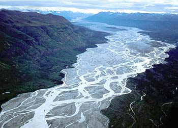
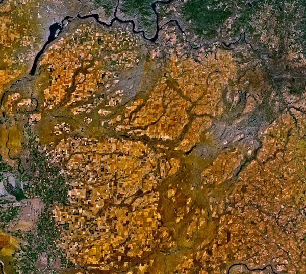
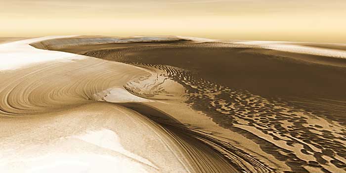
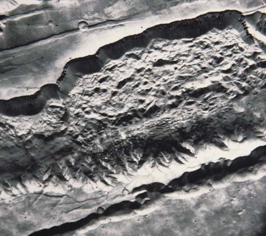
The system of channels in Tiu Vallis is a good example of these broad outflow channels. Tiu Vallis lies at the eastern end of Valles Marineris; it is well over 600 km long, and, in some places, over 25 km wide (Figure 6.13). The floor of the valley is covered by a network of interlacing channels and streamlined erosional forms that may have been islands. Similar patterns are found in braided streams on Earth (Figure 6.14), which usually form in rivers heavily laden with erosional debris. It would be easy to believe that these pictures of martian channels were of parts of the desert areas of the southwestern United States, were it not for the craters and the huge size of the channel. Many layers of rock, which apparently were eroded by running water, are shown in the walls of the valley. Downstream, the channel broadens, the valley floor becomes flat, and the channel appears to empty into Chryse Planitia. In the area west of the Viking 1 landing site, the floodwaters apparently were dammed behind several wrinkle ridges until they overflowed and cut narrow gaps in the ridges (Figure 6.15). The ejecta blanket of the crater in Figure 6.15 has been completely stripped away in many places. The entire region has been sculpted by fluid flow, as channels twist through the area and cut across one another. Teardrop-shaped mesas that were once islands with craters atop them have been streamlined by fluid flow and occur over broad portions of Chryse Planitia, showing how extensive these floods were (Figure 6.16). The craters formed effective barriers to the flow and as the water streamed around them, teardrop-shaped mesas were eroded into the former plain. Terracing, produced as sediment built up around the islands or as rock layers were stripped away, is visible on the sides of many islands.
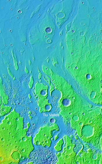
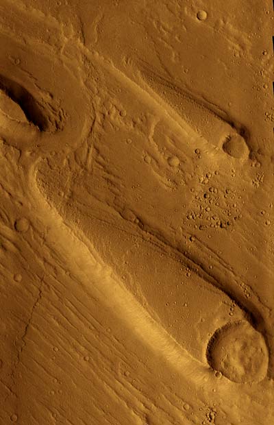
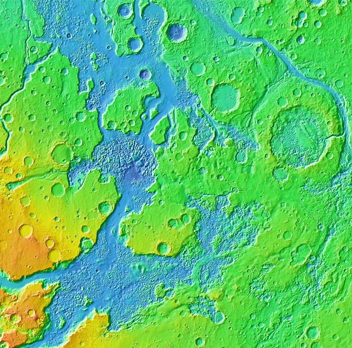
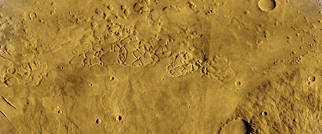
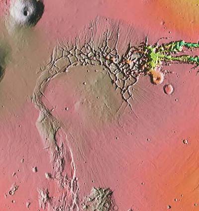
The major channels that flow from the southern highlands across the escarpment to the northern plains are large features---some are over 1000 km long, 100 km wide, and 4 km deep. Such tremendous amounts of erosion must have involved huge quantities of water, but where did the water come from? These outflow channels do not have large, integrated drainage systems with many branches resulting from continuous rain-fed flow. The few tributaries that are present are short and stubby and lack the intricate networks of progressively smaller tributaries that are characteristic of terrestrial streams. Instead, many martian channels have their headwaters in highly fractured regions, or in jumbled masses of large blocks called chaotic terrain. As shown in Figure 6.17, the terrain consists of a complex mosaic of broken slabs and angular blocks with intervening valleys. Chaotic terrain at the eastern end of Valles Marineris is shown in Figure 6.17; the sources of many of the outflow channels, including Tiu Valles, are visible as elongate depressions over 100 km across. Stream channels extend away from the chaotic terrain toward Chryse Planitia.
A possible mechanism for the formation of the chaotic terrain and the large channels involves melting of ice and escape of water from within the layers of the martian crust near the surface. As the ice melted, it may have drained rapidly when the meltwater reached a cliff face. The removal of water in the pore spaces could cause collapse of the overlying rock and the flowing water could cut the channels. Heat to melt subsurface ice reservoirs may have come from intrusions of molten rock; this relationship between volcanoes and channels is especially clear on the western slopes of Elysium Mons (Figure 6.18). Other, larger floods may have resulted from the breakout of confined groundwater. For example, high pore pressure could have been achieved by gravity-driven flow of groundwater down the eastern slope of the Tharsis bulge. This latter suggestion for the source of the liquid water is consistent with the apparent absence of volcanic features near the sources of the Chryse (and most other) outflow channels.
The best terrestrial analog of the outflow channels occurs in Washington's Channeled Scabland. The Scabland consists of a complex network of deep channels cut into basaltic lava flows (Figure 6.19). The braided channels are 15 to 30 m deep, with steep walls and abandoned waterfalls, and cover an area of 40,000 km2. Giant ripple marks and huge bars of sand and gravel were created by catastrophic erosion and deposition. This spectacular topography was caused by the failure of a glacial ice dam, which released millions of cubic meters of water in tremendous floods over the plain. The area was flooded several times as glaciers advanced, formed dams, and then failed.
On Mars, the large unconfined outflow channels apparently did not originate from regional precipitation and collection of rain, but represent the products of several huge floods released at high velocities. During the waning stages of floods, streams were unable to transport all of their sediment and deposited it on the floors of channels to form the braided segments, bars, islands, and terraces. The outflow channels postdate the heavily cratered highlands. In fact, the frequency of fresh craters on the floors of the outflow channels indicates that they are young compared to the valley networks as well as features on the Moon or Mercury. Nonetheless, in an absolute sense they are still very old; water has not flowed through them for millions of years. Some have suggested that the channels around the Chryse Basin are 1 to 2.5 billion years old.
These tremendous floods of water from the outflow channels periodically filled and re-filled a martian ocean, Oceanus Borealis, in the low northern plains. The rise of the Tharsis and Elysium bulges and the development of volcanoes were triggers for the draining of water from the crust. The oceans may have been as deep as 2000 m. Each ocean gradually dried up by evaporation, by sublimation of sea ice, and by water seepage into the floor of the basin to form reservoirs of ground water. When the ocean was filled, water vapor was readily lost to the atmosphere by evaporation. This water vapor would effectively trap heat from the Sun in what is called the greenhouse effect, and temporarily raise the surface temperature. Evaporation from the seas and the later precipitation of rain or snow may have fed a few small, young valley networks. Evaporation from the ocean may have stabilized and fed the growth of a huge glacial ice cap at the south pole. This south polar cap was at one time much larger than it is today. Moreover, carbonate minerals form with ease in standing bodies of shallow water. Eventually, much of the atmospheric carbon dioxide was precipitated leaving the planet cold and dry with but a thin atmosphere. It seems that Mars has seen long periods of little change punctuated by brief periods of exceptional erosion, climate change, and carbonate deposition.
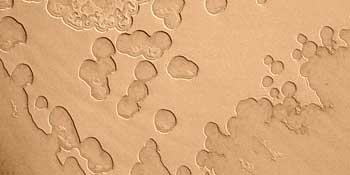
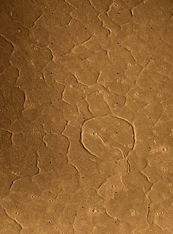
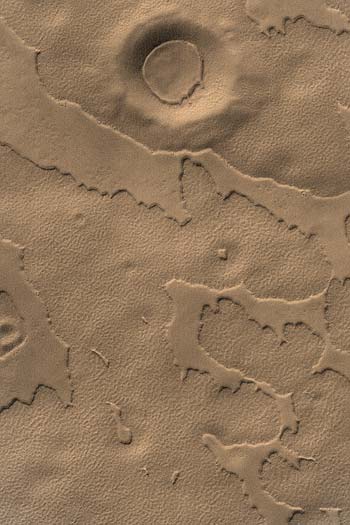
There are numerous indications that significant amounts of water as ice or liquid may occur beneath the martian surface. As we saw in a previous section, the ejecta deposits around many fresh martian craters appear to have been shaped by surface flow (Figure 6.6). Apparently, the ejecta was wet, because impact occurred in ground that contained ice or water and started to flow when it hit the surface. In other areas on Mars, low plateaus may be formed and progressively destroyed as ground ice melts or evaporates and the surface collapses (Figures 6.20 and 6.21). Small depressions eventually grow and merge, forming the scalloped edges of the shrinking plateaus. Moreover, some channels appear to have been fed by springs at the head of box canyons. These springs may have worn away the soft layers, removed support for the upper mass, and allowed the canyon to extend up the regional slope (Figure 6.22). This process is known as sapping and may be particularly active along the edges of channels cut previously. Extensive areas of fractured plains occur in the northern hemisphere (Figure 6.23), and may be similar to the patterned ground that occurs in Earth's polar regions as water in the soil freezes and thaws, forming the characteristic polygonal cracks at the surface. Although there are alternative explanations for some of these features, taken together they indicate that ice is present in the near-surface layers of much of the planet and has played a significant role in modifying and shaping martian landforms.
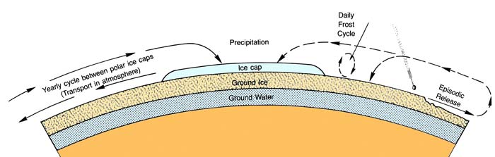
The unique geologic character of Mars is accentuated by its polar ice caps, which are large enough to be visible from Earth. They are of special interest because they are centers of present-day geologic activity and are not relics produced billions of years ago. The polar caps are also a major reservoir of the water on Mars. The structure, rock types, and terrain of the north and south poles are very similar, and in some respects, resemble Earth's ice caps.
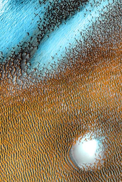
Cratered plains surround both polar areas and apparently extend beneath the ice. In the southern hemisphere, the plains are pitted or etched by irregular depressions. The pits were probably hollowed out by the wind. Extensive wind activity in the northern hemisphere has created a vast circumpolar dune field (Figure 6.24). Dunes are present but less common at the south pole. No young craters have been found in the area covered by dunes, because the actively shifting sands have buried or obscured them.
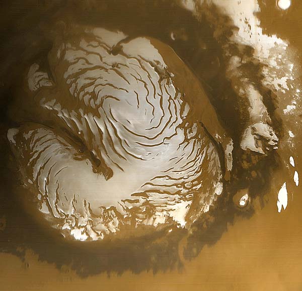
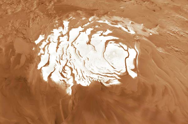
Closer to the poles, a thick series of layered deposits buries the cratered plains. These deposits are a type of sedimentary blanket, cut in many places by deep, spiraling channels that reveal its internal stratification (Figure 6.25). Elsewhere, it is smooth and nearly featureless except where dunes may lap over its margins. The surface is very young and lacks fresh impact craters. The layers are remarkable for their uniformity and continuity and may contain a record of physical processes on Mars in much the same way as sedimentary rocks preserve the geologic history of Earth. As many as 50 beds have been observed in a single slope; their total thickness may be more than a kilometer.
These sedimentary deposits consist of a series of alternating light and dark layers that are essentially horizontal and are thought to have originated from the combined result of ice and wind activity. Possibly the brighter layers are water frozen out of the atmosphere and the darker stripes are interlayered dust and sand blown in by the wind. If these laminated deposits have such a composition, they may contain tremendous amounts of water, which at one time must have resided in the atmosphere or elsewhere on the surface.
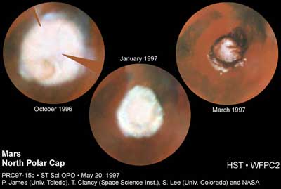
The rotational axis of Mars is presently inclined almost exactly the same as Earth's. As a consequence, Mars experiences seasonal changes. The white polar caps grow in the winter as frost and ice collect on the surface and shrink as the frosty hood sublimates during the summer (Figure 6.26), leaving only a smaller residual ice cap. This temporary frost layer is probably made of dry ice (frozen carbon dioxide) and may be as much as 50 cm thick during the winter. An important observation from the Viking orbiters showed that the residual or permanent cap in the north consists of dirty water ice and is not composed solely of frozen carbon dioxide as once thought. Carbon dioxide ice may dominate the south polar cap, but at the low temperatures encountered there it is difficult to detect water ice, even if it is present. However, the residual ice caps are thin, possibly only a few meters thick and probably less than 1 km. Movement of glacial ice cannot occur until the weight of the ice exceeds its strength; to initiate movement in the low gravitational field of Mars requires greater thicknesses of ices than would be needed on Earth. Thus, at present, the ice caps of Mars may lack the great erosive power of Earth's continental glaciers. Permanent ice covers most of the layered deposits and also occurs as isolated patches in craters or surrounded by dunes farther from the poles. One of the most interesting discoveries is that both polar caps have spiral patterns of dark, frost-free valleys that extend through the residual ice cap and layered terrains. They could be erosional channels formed as the wind sweeps across this bleak, craterless expanse (Figure 6.27). Alternatively, the pinwheel pattern may reflect selective deposition and sublimation of ice, determined by the atmosphere's circulation.
Although the present ice sheets appear to be too thin to flow as glaciers, there is some evidence that thick glaciers formed repeatedly. Glacial ice transports sediment by dragging it along the base of the ice. The sediment may be piled up into long ridges, called moraines, at the front of the glacier. When the ice sheet retreats these ridges are left as evidence of the former extent of the ice sheet. Sinuous ridges on Mars have been interpreted to be glacial moraines that formed when an ancient glacier scoured the landscape. Although there very existence is still extremely controversial, such glaciers may have formed contemporaneous with the seas created by the outflow channels.
Whatever the exact nature and timing of water or ice activity on Mars, it is clear from the presence of stream channels, ground ice, and polar ice caps that water is and has been available to shape the surface. Water resides on Mars at present as vapor in the atmosphere, as ice at the poles, and probably as groundwater or ice in rocks near the surface.
The circulation of water on Earth's surface takes place within a huge hydrologic system that operates continually. The oceans form a vast reservoir of water, which evaporates and moves with the atmosphere. It is then precipitated as rain and snow and constantly bathes the surface of the land. Water may move as surface runoff in streams, as groundwater through pore spaces in rocks, in glacial ice, and eventually as water vapor in the atmosphere before it returns to the ocean and is recirculated. Heat from the Sun drives this system and determines the physical state of the water.
Apparently, Mars developed portions of a similar hydrologic system during part of its history. We have seen that Mars appears to have a differentiated interior that resulted from melting and redistribution of the elements within it. Interior melting has other important consequences. When rocks with appropriate compositions are melted, some of the elements incorporated in the rock---such as oxygen, carbon, hydrogen, argon, nitrogen, and neon (all volatile elements)---are released and form other compounds that are stable under the new conditions. Some of these compounds ultimately form light gases (such as water and carbon dioxide) that easily rise with the molten rock and escape to the surface to form a secondary atmosphere. If the gravity of the planet is sufficient to retain the gas, and if temperatures are high enough, water will remain in a gaseous state; at lower temperatures it may become a liquid and collect in rivers, lakes, and oceans, forming a hydrosphere and initiating circulation in a hydrologic system that shapes surface features, deposits new rock bodies, and has important implications for the evolution of life. If liquid water was stable at the surface of Mars, it would have collected in craters and impact basins. However, the composition of the early martian atmosphere probably did not remain in its primordial state. Chemical reactions of the atmospheric gases with the surface materials modified the composition of the atmosphere and extracted carbon dioxide; additions to the bulk of the atmosphere occurred from continued melting and differentiation in the interior. Some light gases slowly but inexorably escaped into space, while others, such as water vapor and carbon dioxide, froze out of the atmosphere when the temperatures became low enough and formed polar ice caps and ground ice.
Estimates of the total amount of water that may have been released from the martian interior range from a globe-encircling layer 10 m thick to one a kilometer or more in thickness; a reasonable estimate is probably 50 to 200 m. (Earth outgassed enough water to cover its surface, if it were a perfect sphere, to a depth of about 3 km.) In any case, a large quantity of water has been released from the interiors of both Earth and Mars. From the features we have discussed in this section, it is at least conceivable that during the very early history of Mars, a relatively well-integrated hydrologic system existed. The small channels in the ancient highlands may record an epoch of rainfall and collection in rivers and possibly small seas or lakes. If so, Mars must have been warmer then and had a thicker atmosphere that made it possible for liquid water to flow across the surface. Since that time much of the globe has been resurfaced, erasing most of the evidence of this erosional epoch and any evidence for an ancient ocean. About 4 to 3.5 billion years ago, the atmosphere of Mars must have cooled and ice began to form---first in the polar areas, forming ice caps, and later at lower latitudes. Water-saturated ground froze in some places and created ground ice deposits. Later, liquid water, from reservoirs beneath the surface, may have been released when the huge outflow channels and chaotic terrain were formed on the flanks of the Tharsis and Elysium domes. Exposures of ice in cliffs or scarps may have melted or sublimated, forming the box-canyon streams and scalloped plateaus. Meteorite impact, though greatly reduced in this later period, catastrophically melted pockets of ice and incorporated the water into ejecta that flowed like mud as it returned to the surface. During this later, colder episode, the hydrologic system, with its host of components and processes, lost much of its recycling capability (Figure 6.28). Presently, a rudimentary circulation system transfers small quantities of water and carbon dioxide from pole to pole with seasonal changes.
The effects of flowing fluids (gases and liquids) at the surfaces of planets are dramatic. Compare for example, the surfaces of the airless, waterless Moon with Mars. Having considered the role of water on Mars, we now turn our attention to the role of the fluids in the atmosphere.
When Mariner 9 entered orbit around Mars in the fall of 1971, a planetwide dust storm was raging, completely obscuring the surface of the entire globe. The great storm had begun some two months earlier and was observed with Earth-based telescopes as a yellowish cloud which rapidly expanded over the entire planet. The magnitude of such a storm is hard to imagine. Winds comparable to those in a strong hurricane on Earth raged continuously for several months, and dust was blown many kilometers into the air covering the entire globe. Similar dust storms developed during the Viking missions.
The pictures taken by Mariner 9 and the Viking spacecraft revealed that eolian activity has played an important and active role in shaping the surface features of Mars. A variety of wind-shaped landforms have been observed, including (1) groups of long, parallel streaks, (2) dune fields, (3) large stretches of dust and sand mantled terrain, and (4) linear grooves and ridges. The features collectively indicate that wind activity on Mars is quite likely the dominant surface process presently in action, constantly moving and redepositing loose surface material.
The most obvious eolian features on Mars are the systems of parallel plumes or streaks that originate at craters, ridges, or cliffs, and extend hundreds of kilometers across the surface of the planet (Figure 6.29). These features are the result of wind erosion and deposition. Erosion may occur behind some obstacles that create a turbulent flow of the wind. In this case, fine particles may be swept away. In other places a crater rim may be associated with a wind shadow, a pocket of quiet air down wind from the crater, where sand or dust can accumulate. There are light and dark streaks. Pictures taken of the same area at different times show that the shapes of some markings are always changing.
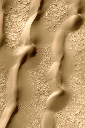
Dunes are great moving piles of sand. Individual grains are moved by the drag of the wind blowing across them. Dunes will not form from dust-sized particles, but require larger grains typical of what we call sand. Dune fields are present on Mars, but are not as conspicuous as the streaks. A field of such dunes covers an area of more than 200 km2 (Figure 6.30) in the Hellespontus region. Well-developed dune forms are widespread in the polar regions; the circumpolar dune field forms a sand sea larger than any on Earth (Figure 6.24). The identification of dunes is important because it proves that martian winds are strong enough to lift loose particles and transport them in spite of the tenuous atmosphere. When these airborne grains hit other surfaces, erosion can occur.
The surface pictures from Viking landers further show the importance of wind activity. Small drifts, with features remarkably similar to many seen in terrestrial deserts, are seen in the spectacular picture of the martian landscape in Figure 6.2. The blocky, angular rocks that mantle the area resemble "desert pavements" produced on Earth where the wind has selectively transported fine sediments, leaving behind a coarse rubble. Drifts of sand have collected behind some rocks where the wind was diverted and the particles it was carrying dropped.
Other evidence for rather large amounts of eolian deposition are the layered deposits of the polar regions, which cover thousands of square kilometers. A thin layer of wind-blown debris may mantle much of the terrain in the high latitudes and subdue the topography beneath it.
Large tracts of the martian highlands show strong evidence that a thick eolian deposit has mantled and subdued the topography of an older surface beneath it (Figure 6.31). The deposits appear to have accumulated in craters and on the surrounding intercrater plains after the intense meteoritic bombardment. The deposits were subsequently stripped away in part, leaving mesas with steep cliffs to mark their former extent. The mantlelike nature of the deposits and their easily eroded character may indicate that they were deposited as extensive sheets of loess during the middle history of Mars. Loess forms when dust-sized particles suspended by the wind settle uniformly over a landscape. Similar layered deposits exist in the polar regions (Figure 6.25), where they cover thousands of square kilometers. The polar deposits appear to be younger and may be interlayered with the deposits of ice or frost.
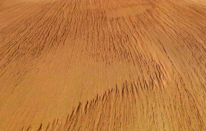
The effects of eolian processes are seen on many of the martian craters. Although they resemble lunar craters in general appearance, they have been distinctly modified by processes other than impact and in this sense they are degraded. Careful study of Figure 6.30 shows that some crater rims appear to be abraded or worn down. There is no sharp upturned lip at the crater margin, as is typical of fresh craters on the Moon, and the rays and ejecta blankets have been eroded or buried. Some investigators have suggested that the wind, in concert with other processes, has subdued the expressions of these craters. Elsewhere, wind erosion is strongly suggested by the pronounced alignment of long, narrow ridges or spines that project from low plateaus, Figure 6.32. The ridge crests are sharp and keel-like, and the ends taper sharply. Similar features, called yardangs, occur in desert regions on Earth; their shape and alignments show that they were formed by wind erosion. It appears that large regions near the equator of Mars were stripped of soft surface layers by this process. Etched terrain, which is particularly common near the south pole, is likewise the product of a different, but less intense, type of wind erosion (Figure 6.33). The basins appear to be the result of deflation. Some believe that the pinwheel shape of the ice caps is due to erosion by outward-spiraling polar winds.
The surface features described above, together with studies of the martian atmosphere, have permitted scientists to draw some conclusions about many parts of the eolian system on Mars and compare it to that of Earth and other planets. Even though a variety of cloud formations have been observed on Mars, the martian atmosphere is still very thin (about 1:100 the pressure of Earth's) and cold. The pressure exerted by the atmosphere at the surface of Mars corresponds to the pressure found at heights of 30 to 40 km above sea level on Earth. Several important consequences result from these differences. For example, the velocity of the wind necessary to start the movement of grains is estimated to be 10 times greater on Mars than on Earth, but once the wind lofts these grains they could have a hundred times more kinetic energy (kinetic energy = 1/2 x mass x velocity2). Mariner 9 data indicate that dust storms in the atmosphere move at velocities in excess of 200 km/hr and gusts of 500 to 600 km/h (half the speed of sound in Earth's atmosphere) do not seem unreasonable, far exceeding wind velocities on Earth. The Viking landers measured wind velocities up to 30 m/sec. Moreover, the thin atmosphere on Mars produces practically no cushioning effect as grains collide. These two factors permit very small particles to act as very effective instruments of erosion. These considerations suggest high erosion rates. In addition, the relatively weak gravitational field plus the thin atmosphere on Mars combine to permit dust and sand to reach heights three to four times greater than on Earth, increasing the opportunity to form huge loess mantles.
Fine, unconsolidated material similar to the lunar regolith, with glass beads and rock fragments, is undoubtedly produced from the impact of meteorites---so loose material is readily available to be picked up and transported by the strong winds. In addition, sand and dust may be produced by volcanic eruptions, mass wasting, and in the stream channels, as well as by continued wind erosion. Ice particles may also be moved by the wind.
Wind action may have continued on Mars without significant interruptions since the origin of its atmosphere. Only rarely have volcanic activity, tectonics, or running water interrupted the processes of the ceaseless winds. On Earth, plate tectonics continually create and destroy the crust, and flowing water has been the dominant surface process from the very beginning. The products of wind action on Earth have been largely restricted to the desert regions and have often been masked by or intimately mixed with the effects of the more universal processes of running water. This has not been the case on Mars; the action of running water has been very limited in scope and duration. All of these factors collectively suggest that eolian processes may have been more intense and proceeded faster on Mars than on Earth. Indeed, wind action is considered by many geologists to be the principal cause of surface changes, shaping martian landforms as universally as running water affects the surface of Earth. It is perhaps amazing that any evidence of the very early history of Mars is preserved at all.
Thus, a major feature that distinguishes Mars from Mercury or the Moon is the existence of a martian atmosphere. This tenuous shell of carbon dioxide and nitrogen, which may at first seem insignificant from a geologic point of view, has markedly changed the surface features of Mars. Even so, the present atmosphere is probably only a fraction of the total amount of volatile gases that were outgassed from the planet. Several estimates based on the present composition of the atmosphere suggest that a layer of water 50 to 200 m thick spread evenly over the planet may have been outgassed; an amount of carbon dioxide equivalent to 1 to 3 bars (1 bar equals the pressure exerted by Earth's atmosphere at sea level) may also have been expelled during the differentiation of the interior. Much of the water released from the interior is now locked up in the polar caps and within the regolith. Even though the formation of carbonates (an important sink for atmospheric volatiles) at the surface is much less efficient than on Earth, the process may have removed some of the carbon dioxide from the martian atmosphere. Carbon dioxide is also locked in the regolith and absorbed onto mineral surfaces. Some nitrogen may have escaped from the top of the atmosphere into space. These processes and the lack of a biologic cycle, which both forms free oxygen (O2) and helps tie up carbon dioxide in solids, have created a martian atmosphere that is similar in composition to that of Venus but much thinner---95 percent carbon dioxide, 3 percent nitrogen, and 1.6 percent argon with only traces of water vapor, oxygen, and other gases.
The Viking orbiter photography, with its great detail, provides dramatic evidence that mass movement, the gravity-driven downhill movement of unconsolidated material, is an important process in the evolution of the landscape of Mars and is especially important in the enlargement of the canyons and development of chaotic terrain. The variety of mass-movement features on Mars includes those produced by the rapid and devastating effects of tremendous landslides as well as features produced by slow, downslope creep of loose material.
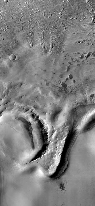
Figure 6.34 shows a section of Valles Marineris and illustrates the role that mass movement has played in slope retreat and enlargement of the canyon. Here the canyon is about 5 km deep, and several massive landslides are visible. Resistant rock layers form a steep cliff at the top of the plateau and appear to have broken into a series of relatively coherent slump blocks, whereas the lower slopes appear to have flowed away in a surge of moving debris. Some of these tongue-shaped deposits extend across the canyon floor, at least 50 km from their point of origin.
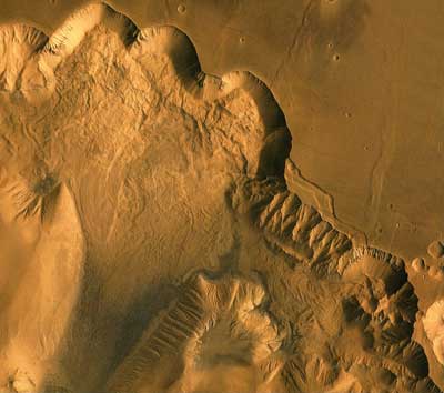
Figure 6.35 provides a broader view of Valles Marineris and the gigantic landslides along the walls. The canyon was originally formed by subsidence along a series of parallel faults extending from the crest of the Tharsis upwarp. Many small grabens can be seen on the flat plateau surface; earthquakes along these faults may have triggered the great slumps that widen the walls of the major canyons.
Mass movement is, of course, of prime importance in the development of the chaotic terrain discussed in a previous section. As ground ice melts or as aquifers break through to the surface, the support for the overlying rock is removed. It may then collapse and form huge, muddy debris flows and slump blocks on the steep walls (Figure 6.17).
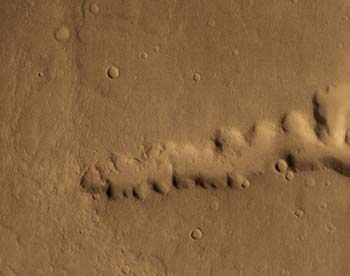
Similar mass-movement processes probably sculpted the fretted and knobby terrain skirting the global escarpment (Figure 6.36). The fretted terrain consists of a maze of flat-topped buttes and linear valleys, which are probably controlled by fractures in the crust. This photo shows how the escarpment retreats---material is shed off the cliffs by mass movement and is eventually removed by fluvial or eolian processes or buried by later lava flows or other debris flows. Melting or sublimation of ice in these materials may substantially contribute to this mode of erosional evolution. Eventually only small knobs or hills are left to mark the former extent of the plateau
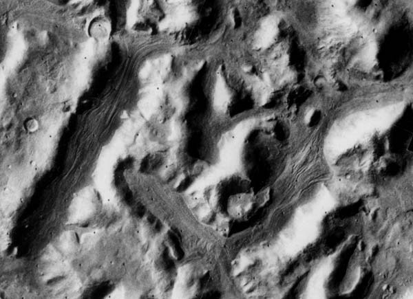
The detailed photograph shown in Figure 6.37 reveals another type of slow mass movement in the fretted terrain. On the floors of these trenchlike valleys surface materials appear to have moved or flowed slowly downhill, possibly aided by freezing and thawing of ice in the spaces between fragments. In this area mass movement causes slope retreat and also transports the material downslope, like a valley of glacier on Earth.
Although landforms produced by the direct, gravity-driven movement of slope materials have been observed on the steep walls of lunar craters, the process has not proceeded as dramatically as on Mars. The role of melting ground ice on Mars is probably the most important reason for the great difference.
The discovery of huge volcanoes in the northern hemisphere of Mars was one of the most significant results of the flight of Mariner 9 in 1971. Previous Mariner missions (4, 6, and 7) sent back pictures of the southern hemisphere, which, for the most part, is densely cratered and superficially resembles the lunar highlands. Therefore, the existence of enormous volcanoes on Mars was entirely unexpected. Yet, when the rest of the planet was photographed by Mariner 9, it became clear that prominent volcanic features occur over a significant part of the planet, and their lack of superposed craters suggests that Mars continued to experience volcanism relatively late in its history (during the last billion years). Later, detailed studies revealed that there are many older volcanoes as well, although they are highly eroded and difficult to recognize. It appears that Mars has had a long and interesting volcanic history.
Three major types of volcanic features, including several types not found on Mercury or the Moon, are found on Mars. The most striking are the giant shields concentrated primarily in the northern hemisphere. There are also large volcanic structures with very low profiles and large central craters called patera (saucers). The third type of volcanic feature, less spectacular but nonetheless very significant, includes the volcanic plains, which form much of the sparsely cratered regions in the northern hemisphere and are similar to the plains of Mercury and to the lunar maria.
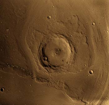
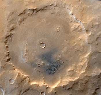
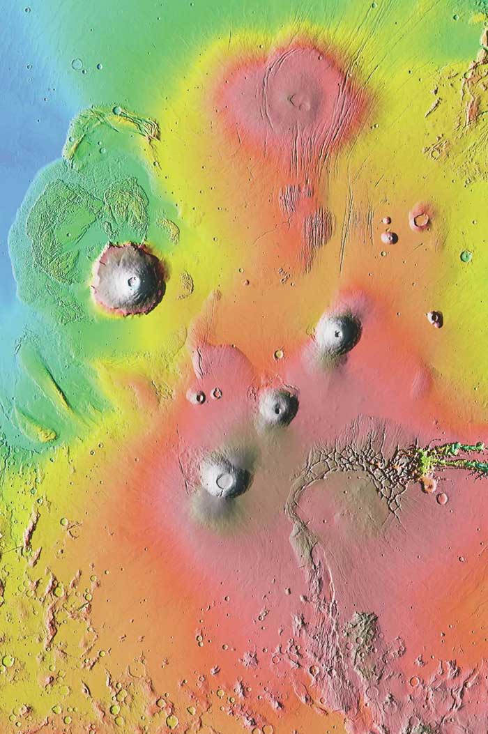
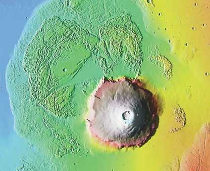
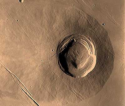
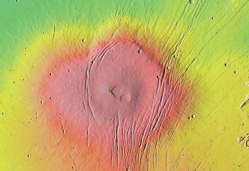
The most spectacular volcanic features on Mars are the enormous shield volcanoes, which have no analog on the Moon or Mercury. Most of the shield volcanoes occur in the Tharsis region, where twelve large and several smaller volcanoes developed (Figure 6.38). The Elysium region is smaller and has only three large volcanoes (Figure 6.39). The largest volcano is at least twice the size of the largest volcano on Earth. The most dramatic is Olympus Mons, which lies west of the Tharsis ridge. It is about 550 km in diameter (five times larger than the largest on Earth) and rises 25 km (82,000 ft) above the surrounding plain. This is half again the distance from the depths of the Mariana Trench to the top of Mt. Everest, the deepest and highest points on Earth. The mosaic in Figure 6.40 shows that Olympus Mons has a complex crater at its summit called a caldera. These large calderas are not vents but depressions, produced when the peak of the cone collapsed and subsided along circular faults as magma was withdrawn from shallow reservoirs in the volcano. High-resolution photography of the flanks of Olympus Mons shows many of the individual flows that make up the cone (Figure 6.41). There are many long ridges radial to the central caldera, narrow channels that resemble collapsed lava tubes or lava channels, and fingerlike flows. All of these flow types are found on terrestrial shield volcanoes, suggesting that the physical nature of the lava that made them is similar to terrestrial basalt.
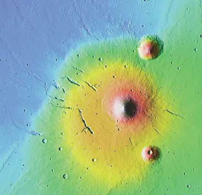
Portions of the base of Olympus Mons form a steep cliff several kilometers high, which is receding by slumping and gully erosion. Originally the volcanic cone probably graded smoothly into the surrounding plain. In places the scarp has been flooded by younger lavas, reestablishing a smooth profile (Figure 6.40).
The other large shield volcanoes in the Tharsis and Elysium areas resemble Olympus Mons but differ in size and detail. All are relatively young features, as is indicated by the remarkably fresh surface features of the lava flows, sharp rims of their summit caldera, and the lack of impact craters. Olympus Mons is probably the youngest of the large shield volcanoes; according to some crater counts, it may be as young as 200 million years old and would have been built while reptiles dominated life on Earth.
The large shield volcanoes of the Tharsis and Elysium regions appear to be associated with large domes in the lithosphere, both of which may be the result of thermal processes within the deep interior, which bulged and fractured the lithosphere and produced the magmas.
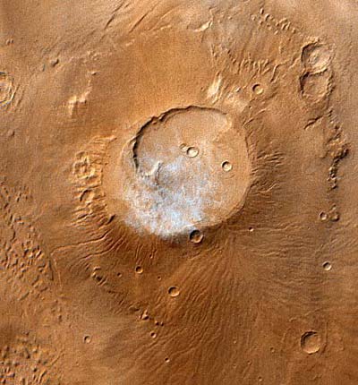
In addition to the large shield volcanoes, a number of smaller volcanic shields are scattered across the planet. They are typically slightly steeper than the large shields but they commonly have summit calderas and radiating channels (Figure 6.42). They may simply be small shield volcanoes produced over a limited magma source, but some geologists believe that because they have such large calderas they are the summits of nearly buried shields.
Possibly the largest volcanic structure on Mars is not a shield volcano at all, but a very low profile feature with a large caldera, or vent area called Alba Patera (Figure 6.43). It may be over 1500 km in diameter. The central portion of the structure is surrounded by a circular set of fractures along which the volcano may have subsided somewhat. Extremely long lava flows that appear to be as young as those in Tharsis emanate from its center and extend for more than 1000 km away from their vents. Small hills around the margins of this huge structure may be cinder cones or lava domes. In short, it appears that Alba Patera was formed by a complex series of volcanic and tectonic events. No similar volcanic structures have been found on any of the other planets.
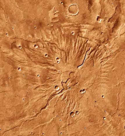
Other patera volcanoes occur in the southern hemisphere and appear to be very old (Figure 6.44). Tyrrhena Patera, (Figure 6.45) northeast of Hellas Basin, is extremely degraded and appears to be surrounded by younger plains. By crater counts, Tyrrhena Patera is estimated to be over 3 billion years old. Thus, eruptions from central volcanoes, shields, and pateras, have apparently extended over a large span of martian history. Some pateras may have experienced an early phase of explosive volcanism that emplaced thick sheets of volcanic ash. The explosions may have been generated as hot magma rose through the water-saturated regolith of the ancient highlands. The tremendous change in the volume of water as it passes from liquid to gaseous states may trigger such eruptions. On Tyrrhena these initial explosions were followed by the quieter eruptions of lavas, which appear to have formed the deep channels on its flanks. Alternatively, the channels may have been cut by water released from the regolith by volcanic activity.
Although the great shield volcanoes present the most spectacular evidence of volcanic activity on Mars, the lava flows of the plains regions may represent much greater volumes of volcanic material extruded from the interior and are certainly important because of their similarity to the flood basalts on other planets. Indeed over 60 percent of the planet is covered by plains, a substantial portion of which may be of volcanic origin. Geologic evidence shows that volcanic plains were formed in the ancient highlands (similar to Mercury's intercrater plains) and in the vast northern lowlands. Their emplacement appears to have spanned the entire length of martian history. Knowledge of their absolute ages will be important for determining the thermal evolution of Mars.
Various features are used to identify volcanic plains, the most obvious being the presence of flow fronts (Figure 6.46A). Less definitive are the wrinkle ridges, which are ubiquitous on the highland plains thought to be volcanic (Figure 6.46B). The sheetlike nature of most of these deposits and the large volumes involved suggest that the eruptions occurred from large fracturelike vents with high flow rates typical for flood lavas. Some plains (Figure 6.46C) are dotted by low conical mounds several kilometers across, with depressions at their summits. These low shields and the surrounding plain are the result of small eruptions from numerous pipelike vents that may be localized along large fracture systems and are representative of basaltic plains.
The detailed nature of the northern plains remains unresolved, but much of the area probably consists of lava flows. Information collected by the Viking landers suggests that the bedrock may consist of iron-rich, basaltic lavas. Moreover, the rocks seen on the surface by the landers are frothy, like those produced in gas-rich lava flows on Earth. Flow margins are also evident in some areas and resemble those in the lunar maria. Some of the youngest plains on the planet, lying near the equator, have been interpreted as large ash-flow or ash-fall deposits (Figure 6.46D), but no vents have yet been identified. In short, the geology of the martian plains is much more complex than that of the lunar maria, as the plains were probably built up by fluvial and eolian deposits as well as volcanic flows. Subsequent modifications by ice-related phenomena have further complicated our attempts to understand the origin of the northern plains.
The large range of ages for the various volcanic features clearly shows that Mars has been thermally active during most, if not all, of its history. In addition, we have seen evidence for several types of volcanic processes that did not develop on the Moon or the portion of Mercury photographed by Mariner 10. The unique style of volcanic processes indicates significant planetary differences, which must be, at least in part, the result of the size and composition of Mars.
The presence of undeformed craters across the surface of Mars clearly indicates that the crust has not been subjected to extensive horizontal compression since the period of intense bombardment. There are no mountain ranges made of folded layers of rock and no active system of moving plates. Yet there are some very important tectonic features on Mars, produced by extension of and compression of the rigid lithosphere. These are convincing evidence that significant tectonic deformation has occurred throughout martian history.
The unique tectonic character of Mars is marked by large domal upwarps in the crust and extensive fracture systems associated with the production of these bulges. Other small wrinkle ridges and graben are also present, but were probably the result of local vertical adjustments.
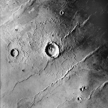
Several large domal upwarps occur on Mars; features which are not found on the Moon or Mercury. The two largest are in the Tharsis and Elysium regions, near the global escarpment. Both are capped with large volcanic cones (Figure 6.1). The Tharsis dome is a broad bulge 4000 km in diameter and 6 to 7 km high. A row of volcanoes, some with an extra 15 km of relief, cross the crest of the dome. This upwarp is much steeper on the northwestern side, where it rises from the low northern plains and therefore has an asymmetric profile. The Elysium dome is smaller, only 1500 to 2000 km across and 2 to 3 km high. The volcanoes there are less numerous and smaller.
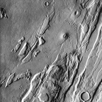
The domes in the lithosphere on Mars are associated with large fracture systems that make spectacular patterns on the surface. The most extensive fracture system is northeast of Tharsis where a fanlike array of grabens and fractures converge toward the row of shield volcanoes. This system of faults and fractures extends across a third of the planet. The fractures form magnificent sets of grabens which are typically 1 to 5 km wide and may be several thousand kilometers long (Figure 6.47). Wherever older terrain is exposed, the rocks are intensely fractured by the intersection of several sets of grabens with different orientations. It is almost certain that these fault systems extend beneath the young volcanic terrain. They represent a complex history of structural deformation by extension of the lithosphere.
The fractures appear to have been produced as the brittle lithosphere bulged upward and cracked. The location of the volcanoes on Tharsis ridge was probably controlled or facilitated by these fractures. The association in space and time of large domes in the martian lithosphere, graben and rift formation, and volcanism suggests that they may all have a common cause that is rooted in the flow of material in the mantle. Convective movements within the mantle may have pushed up and arched the overlying lithosphere to produce the domes. If solids in the mantle rise very far, they may become partially molten in the low pressure environment. This type of melting will occur even in the absence of any temperature rise. Once a molten magma is formed it may rise even farther, because of its low density, and eventually feed a volcano. It seems that mantle convection may occur by the buoyant rise of less dense (warm) mantle material in cylindrical pipes of upwelling mantle. Such feature have been called mantle plumes. The return flow of cold dense mantle probably occurs in cylindrical plumes of downwelling mantle.
From crater densities on the faulted surfaces, it seems quite likely that the major tectonic events that produced the Tharsis rise ended about 1 billion years ago, and were followed by a series of volcanic eruptions that formed the shield volcanoes and young plains. Apparently, Mars remained tectonically active long after the smaller Moon had cooled and "died."
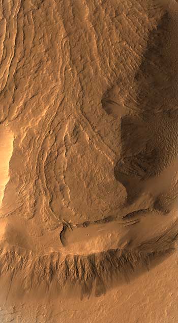
A better insight into the type of tectonism that operated on Mars can be derived from a close inspection of the western part of the Tharsis fracture system. Earlier, we mentioned the vast system of interconnecting canyons called Valles Marineris; their location and size is controlled at least in part by fractures developed around the Tharsis dome. The huge dimensions of this feature are vividly shown in Figure 6.48, in which an outline map of the United States is superimposed for scale. This great canyon system is more than 4000 km long, 700 km wide, and as much as 7 km (20,000 feet) deep, dwarfing terrestrial river canyons. By comparison, the Grand Canyon of the Colorado River would be a minor tributary. The canyons of Valles Marineris consist of a series of parallel depressions with steep walls that drop abruptly from an upland plain. The troughs are highly irregular in detail, with sharp indentations caused by landslides, and scallops and side canyons that may have been shaped by running water derived from ground ice. Much of the relief, however, is clearly the result of faulting along the fault system radial to the Tharsis bulge. Considerable erosion has widened the canyon walls, but the trace of the faults, along which vertical movement has occurred, is clear at the base of the cliffs.
Valles Marineris can be divided into three major divisions from west to east. Nearest the dome in the Tharsis region is an intricate labyrinth of intersecting canyons called Noctis Labyrinthus (Figure 6.49). The canyons that form this section are controlled by a set of intersecting fracture systems and are characteristically short and narrow. They thus divide the cratered plains of the plateau into a mosaic of blocks forming a huge maze. The labyrinth may have developed directly over the dome which produced the fractures and stands at an elevation of about 10 km. This set of canyons appears to have formed by localized collapse as the floors subsided rather than by erosion and transportation of material out of the canyons.
The central portion of the canyons consists of a system of long parallel troughs which extend a distance of 2400 km. They are the deepest depressions, with some walls rising 7 km above the valley floor. Throughout this section, Valles Marineris consists of chains of pits, all oriented in an east-southeast direction. In many places the floor is covered with landslide debris or cracked by movements along faults, suggesting that the topography was produced by subsidence of the floor along faults at the foot of the canyon walls, but usually the floor is smooth and featureless. In some of the broader canyons, plateaus of layered rocks have been found on the floor. Some scientists suggest that these are the eroded remnants of sediments deposited in ancient lakes that formed within the canyons; others suggest that they are merely the eroded remnants of the ancient martian crust isolated within the canyons.
The far eastern part of Valles Marineris is a series of irregular depressions that merge into chaotic terrain even farther east (Figure 6.50). Large areas of collapsed terrain have probably resulted from the removal of ground ice. Faults are not as obvious here, and the canyons are much more shallow and the floors are hummocky; apparently, these canyons were formed more by flowing water than by subsidence along faults. Valles Marineris is continuous with several chaotic areas, the largest being Aureum Chaos and Hydroates Chaos, which connect with the large channels that drain into the northern lowlands.
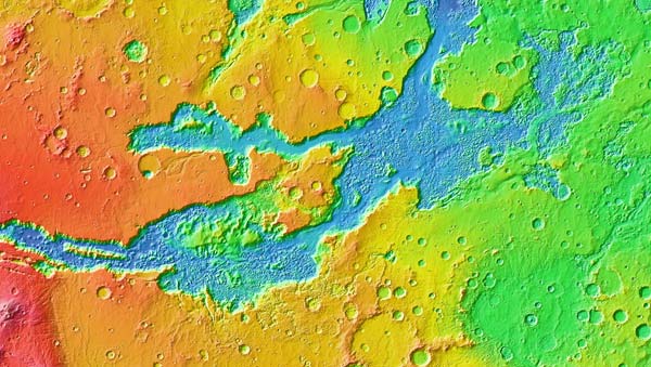
The enormous canyons of Valles Marineris are complex, involving tectonic activity and a variety of erosional processes. Faulting related to the creation of the Tharsis bulge appears to have played a key role in its formation by providing differential relief and zones of weakness, both necessary conditions for significant erosion to occur on Mars
The features on Earth most comparable in size and nature to Valles Marineris are the Red Sea and the east African rift valleys. A rift valley forms where the crust is pulled apart, creating a system of parallel faults that allow an inner zone to subside, creating a large valley. Valles Marineris may have originated in a similar manner, as fractures developed along the crest of a large flexure in the crust and allowed the interior block to subside. Subsequently, the rims of the valleys were sculpted by erosional processes, producing the present topography. A much smaller set of fractures occurs around the Elysium dome and may reflect similar events that occurred there.
Other areas of Mars are cut by smaller grabens and faults (Figure 6.47). In fact, much of the global escarpment is transected by linear patterns, suggesting that its evolution has been controlled in part by a set of fractures and joints, which have accelerated its recession. The thinner crust in the northern plains may have been more extensively fractured early in the history of Mars, possibly even as a result of thermal expansion of the entire planet.
In the plains, wrinkle or mare-type ridges are very well developed and extend for many kilometers across the surface (Figure 6.51). Generally, the ridges occur in sets that parallel regional depressions, as in the Chryse area, which may indicate that they were produced by buckling of the near-surface deposits (perhaps lava flows) just as has been postulated for the Moon.
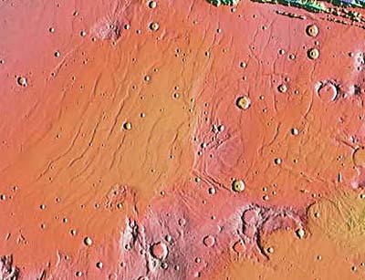
The development of domal upwarps and associated fracture systems clearly represents major tectonic events in the geologic history of Mars, events not shared by the Moon or Mercury. It appears that this tectonism had some relationship with the focus of the youngest volcanic activity on the planet. On the Moon, we saw that tectonic activity and the deformation of the outer layers of the planet ceased between 2 and 3 billion years ago and, even then most of the changes were only minor, related to more or less passive changes, such as the vertical adjustments of mare basins. Mercury experienced global contraction as it cooled. Mars is a more dynamic planet and experienced some tectonism in the form of crustal doming and rift formation at least until a billion or so years ago. Apparently because of the larger size of Mars, it progressed more slowly through its thermal evolution and the duration of its tectonic systems was longer producing young features. Mars has a mixture of Moonlike features modified by some Earthlike processes. Even though no evidence of past plate motions has been preserved on the surface, mantle convection has produced some very obvious changes to the cratered landscape
By careful mapping of the surface of Mars, distinctive terrain units have been identified on the basis of their topography, color, and brightness. Using the principles of superposition and crater frequency, these geologic units, and the processes which formed them, can be placed in their proper time sequence. The formal names applied to these periods of time are, from oldest to youngest, Noachian, Hesperian, and Amazonian. The names are taken from prominent geographic regions on Mars. The absolute ages of these geologic periods are subject to great uncertainty, because no rocks have been collected from the surface of Mars and because the rate of meteorite impact on Mars is not known and cannot be simply tied to the dated cratering record on the Moon. Even though the actual ages of these developmental stages are not known precisely, they provide an important framework for developing the history of Mars
Six major stages in the evolution of Mars are recognized; each stage involves distinct events or processes but they may overlap somewhat in time. The effects of the major events in the geologic evolution of the interior and surface of Mars are shown in the series of diagrams in Figures in 6.52 and 6.53.
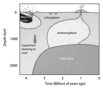
Mars, like all the other planets, is believed to have formed by accretion of a myriad of smaller bodies over a fairly short period of time about 4.6 billion years ago. As the planet grew and developed a larger gravity field, the infalling debris was collected at higher speeds. Consequently, the impacts released large amounts of heat. Probably much of the planet was melted by this accretionary heat that was augmented by radiogenic heat produced internally. As a result, Mars may have differentiated internally, forming an atmosphere, crust, mantle, and core. If the initial heating of Mars was great enough, a magma ocean may have formed from which the primordial crust crystallized. This crust was probably basaltic and not anorthositic, as on the Moon. Great variations in crustal thickness may have been inherited from this time. On Mars, the crust in the northern hemisphere appears to be thinner than that in the south.
The gases and water that are presently at or near the surface were probably released from the interior of Mars during this early stage, to form a primordial atmosphere and hydrosphere (Figure 6.53A). The presence of these fluids near the surface of Mars resulted from its more volatile-rich composition as compared to Mercury or the Moon.
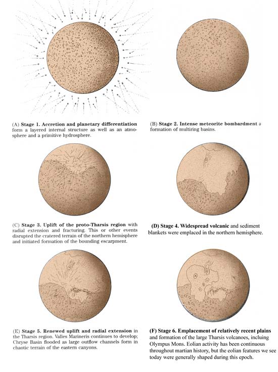
During and following its formation as a planet, Mars was subjected to a period of intense meteoritic bombardment. Crust formation predated the end of the catastrophic bombardment, and a densely cratered surface such as that shown in Figure 6.53B, including several multiring basins, was formed. In fact, a few geologists have speculated that the ultimate cause of the north-south dichotomy was the impact of a huge body, which thinned the crust of the northern hemisphere. The asteroids, the Moon, Mercury, and presumably even Earth experienced similar impact-dominated early histories.
An early period of widespread lava flooding is represented by extensive tracts of plains between and within the ancient craters. The plains are similar in appearance to the mercurian intercrater plains, and in some cases, show distinctive features of volcanic activity. Thus, the oldest rocks on Mars must consist of interlayered and overlapping ejecta blankets and lava flows formed shortly after the planet's accretion. By about 3.5 billion years ago, the rate of meteorite impact had probably declined to very near the present low rate.
The early martian atmosphere was quite likely more dense, and temperatures were probably higher, perhaps sufficient to allow liquid water to flow across the surface. If so, rainfall and flooding would have caused significant erosion of the highlands and the runoff may have collected in local basins in the southern highlands and in the northern lowlands as ephemeral lakes or seas. The small filamentous channels of the highlands may be remnants of these ancient river systems. However, evidence for a thicker atmosphere early in martian history is at best equivocal. An alternative explanation for the valley networks holds that they were formed as groundwater, stored in the crust at some earlier time, seeped to the surface and created valleys by sapping at springs.
Vast sheets of flood lava formed some of the ridged highland plains. Lavas are probably interlayered with eolian sediments in the huge areas of highlands that were resurfaced at this time. Several large volcanic fields formed in the southern hemisphere around volcanic patera, such as Tyrrhena Patera.
Regional uplift in the Tharsis area began and was accompanied by radial faulting and volcanism, presumably because of plume convection in the mantle. Valles Marineris began its development along a structural trough in the fracture system. Much of the crust in the northern hemisphere may have been extensively fractured at this time, possibly because it was thinner there than in the southern hemisphere. In addition, slow expansion of the entire planet due to radioactive warming of its deep interior may have contributed to the tectonic breakup of the northern hemisphere (Figure 6.53C).
Probably during this or an earlier stage, the temperature at the surface began to drop as less heat was being released from the interior. Water became locked up beneath the surface as ground ice or in the polar caps. Carbon dioxide from the atmosphere may have been trapped in carbonate minerals formed at the surface. Atmospheric pressure probably dropped, partly as a result of the removal of water vapor and carbon dioxide from the air, but also because of the slow, inexorable loss of gas into space. Both of these processes made it very unlikely for water to exist as a liquid on the surface. Much of the erosion along the global escarpment occurred just before or during Stage 4.
Widespread volcanic activity and deposition of eolian and perhaps fluvial sedimentary rocks occurred in the northern hemisphere to form great, low, sparsely cratered plains (Figure 6.53D). Eruptions of flood lavas formed the lunar maria and plains of Mercury and then stopped, probably several billion years ago, but on Mars, volcanic activity continued intermittently over a much longer period of time, possibly to the present. The amount of volcanism appears to have declined with time. The large volcanoes in Elysium, sitting atop a large crustal swell, began to erupt during this epoch. Highland volcanic centers also developed.
Recurrent uplift in the Tharsis region formed additional radial faults and was accompanied by episodic volcanic outpourings to create the Tharsis volcanoes. Valles Marineris was progressively modified by filling with sediments and then enlarged by continued faulting and slumping. Catastrophic outbreaks of groundwater, possibly as a result of the formation of the Tharsis rise, released floods of water, to form the chaotic terrain and large outflow channels of the eastern canyon system. These catastrophic floods carried sediment downslope to Chryse Basin in the northern lowlands and filled temporary seas. The chaotic terrain enlarged and the global escarpment continued to retreat southward. Major volcanism and related outburst of groundwater occurred in the Elysium province as well. Eolian and volcanic processes also resurfaced portions of the northern plains (Figure 6.53E).
Volcanic extrusions partly covered the Tharsis area with fresh lava, and the most recent lava flows on Olympus Mons were erupted at this time (Figure 6.53F). However, the volume of magma erupted was significantly lower than in previous epochs, a clear indication that Mars was cooling to the critical level beyond which no volcanism can occur. Channels, probably related to melting of ground ice by volcanic activity, formed west of Olympus Mons. Eolian activity persisted, modifying the entire surface while the polar layered terrains and surrounding dune fields continued to develop.
Mars has certainly passed its peak in geologic activity; it is likely that even the volcano Olympus Mons has been inactive for tens or hundreds of millions of years. As Mars continues to cool, radiating its energy away to space, active geologic processes such as faulting and volcanism will continue to wind down. At present, eolian processes are the dominant active geologic agents shaping martian surface features, although sublimation of ice and mass movement may continue to cause slope retreat along the global escarpment and along steep crater or canyon walls.
Although critical data are missing, particularly radiometric dates of the various rock units, a complex and fascinating history of Mars is arising from the study of relative ages. Tantalizing hints of further complexities and geologic paradoxes remain for generations of scientists to decipher and integrate into this framework for the geologic history of Mars.
The geological exploration of Mars has been a highlight of the space program and has revolutionized our knowledge of the red planet. Eight American spacecraft have successfully returned thousands of photographs and other data pertinent to deciphering its geologic history. Recent space missions have revealed that Mars is an enormously exciting place of vast geologic interest. We have seen Mars closeup, landed on its surface, mapped its terrains, and found out what Mars is really like. Some of the more important discoveries are summarized below.
Much of the martian surface is cratered, some of it so intensely that it may be inherited from the close of the heavy bombardment (on the Moon these regions are about 4 billion years old). The craters on Mars are similar in size to those on the Moon, but show evidence of greater modification by erosion and burial. Many martian craters have a unique appearance, caused by the motions of fluid ejecta that flowed across the surface.
The great shield volcanoes in the Tharsis and Elysium regions and the vast volcanic plains clearly indicate that Mars has experienced more volcanic activity later in its history than the Moon. Moreover, distinctive central volcanoes are important on Mars but not seen on Mercury or the Moon.
Two large domal upwarps in the Tharsis and Elysium regions stand out as the major tectonic features of Mars. A pattern of radial fractures extends out from the Tharsis region over much of the western hemisphere. The great canyons of Noctis Labyrinthus and Valles Marineris formed as part of this system of extensional faults. Compressive forces have also deformed large regions of Mars, buckling the crust to form wrinkle ridges. Even so, no folded mountain belts, like those on Earth, formed and no system of mobile lithospheric plates was sustained. Tectonic (domes and graben) and volcanic features (localized on and near the domes) on Mars suggest that mantle plumes are an important kind of mantle convection.
Systems of stream channels exist on Mars. The largest originate in the southern highlands, cross the global escarpment, and terminate in the low plains to the north where shallow temporary seas waxed and waned. Their headwaters originate in chaotic terrain marked by collapse structures. Smaller, more ancient channels occur on old volcanic mountains, crater rims, and as small branching systems. They may represent a major erosional interval early in martian history, when liquid water was available at the surface, when temperatures were higher, and when the atmosphere was thicker. Much of this water now resides in polar ice caps or as ice within the surface layers.
Huge landslides and debris flows and other types of gravity driven mass movement have been important processes in the development of the martian landscape, enlarging or modifying the canyons of Valles Marineris. The chaotic terrain is another expression of large-scale mass movement, involving collapse as subsurface ice melted and flowed away.
Winds gusting up to 200 km per hour sweep much of the surface during the global dust storms that periodically rage across the planet. Numerous streaks, dunes, and grooves show that the wind may be the dominant geologic process still active. Surface photographs from the Viking landers show many small eolian features such as sand ridges, dunes, and a type of desert pavement.
Superposition and crosscutting relationships show that Mars has had an eventful geologic history involving, in sequence, (1) accretion and internal differentiation, including outgassing of an atmosphere, (2) formation of a densely cratered surface, perhaps during a period when the atmosphere was thicker and a hydrologic system operated, (3) uplift and radial fracturing of the crust in the Tharsis region, (4) widespread obliteration of the cratered terrain in the northern hemisphere, perhaps accompanied by extrusion of lava and deposition of sediment to form the northern plains, (5) renewed uplift and volcanism in the Tharsis region with the development of Valles Marineris and episodic release of groundwater in vast floods to create the outflow channels, and (6) modification of the surface, mainly by eolian deposition and erosion in a cold, dry environment.
Although Mars is still a relatively primitive planet, in the sense that it has large tracts of heavily cratered terrain, it is far more Earth-like than the other inner planets we have examined. Mars has an atmosphere and a partial hydrologic system that worked together to provide a diverse arrangement of landforms. Mars is intermediate in size between the small terrestrial planets (Moon and Mercury) and the larger ones (Earth and Venus), and its thermal evolution also appears to have been intermediate, resulting in the production of mantle plumes, lithospheric domes and an extensive and varied volcanic history.
Important factors that affect the thermal evolution of a planet and in turn help determine the nature of its geologic processes include its mass, diameter, and composition. Mars has almost twice the mass of Mercury, but a larger diameter and lower bulk density. Thus, it has a slightly smaller surface-area mass ratio. Calculations suggest that the martian cooling rate was slower, maintaining high internal temperatures for billions of years. Perhaps as a result of this slower cooling rate, Mars experienced a longer period of volcanic activity than is apparent on Mercury or the Moon (Figure 6.52).
Some scientists think that both the low density and long thermal evolution of Mars may have been caused, in part, by significant differences in the composition of Mars (and not just its size), as compared to either Mercury or the Moon. The presence of an atmosphere and water-related features support this assumption, as both are absent on Mercury or the Moon. Mars accreted at a distance farther from the early Sun than the rest of the inner planets and possibly at lower temperatures or pressures. These conditions probably allowed volatile-rich materials to condense from the nebula and become incorporated in the planet. If so, internal melting and convection in Mars may have occurred at lower temperatures than in Mercury, for example, and could have persisted to more recent periods of time. Other compositional differences, especially regarding the proportions of radioactive elements may have helped slow the cooling history of Mars as compared to the Moon and Mercury.
Mars is more complex and geologically diverse than the Moon and Mercury in other ways as well. Tectonic disturbances, such as the Tharsis uplift, have altered the face of the planet dramatically. No contraction on a global scale is indicated. Internal circulation, or convection, in the hot, plastic mantle is thought to be the driving force behind much of this tectonic diversity. These internal motions provided forces that arched and cracked the thickening lithosphere, producing the vast fracture systems and localizing volcanic activity. However, the lithosphere of Mars apparently lacked lateral density contrasts and thickened more rapidly than Earth's. Thus, the lithosphere was not broken into a system of moving plates. Instead, persistent melting beneath the lithosphere produced huge volcanic piles, not the volcanic chains formed on a moving lithosphere like Earth's.