
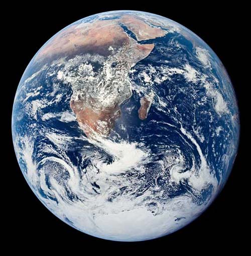
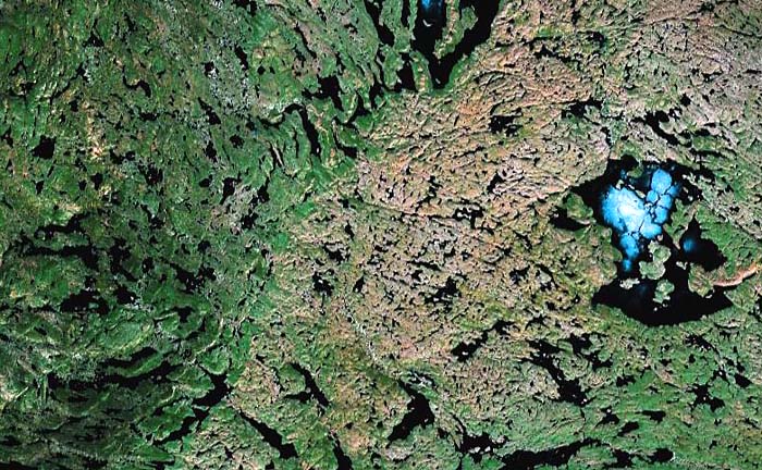
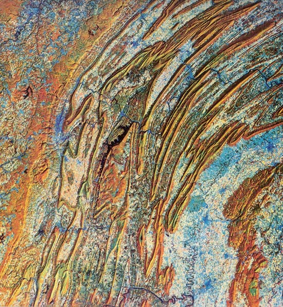
Viewed from space, Earth presents a fascinating range of surface features (Figure 8.1). By an alien scientist it might be called the Blue Planet; but the deserts, such as the Sahara, are distinctly orange and the lush vegetation gives the tropics a deep greenish hue. Contrasting beautifully with the azure blue are the white streamers of clouds and the massive ice cap of Antarctica. To many, the breathtaking photographs of Earth from space may be simple items of great beauty, but to the student of geology they reveal much more than mere clouds, oceans, and continents. These photographs tell us much about how the planet works as a dynamic system undergoing constant change.
1. Earth, like the other rocky inner planets, is differentiated with a dense iron-rich core that is still partially molten, a thick mantle of iron- and magnesium-rich silicates, and a crust of silica-rich and magnesium-poor rocks.
2. The present atmosphere contrasts sharply with those around other inner planets because it is poor in carbon dioxide, rich in the residual nitrogen, and also rich in oxygen.
3. Earth's lithosphere is ten to several hundred kilometers thick and is thinner and more mobile than that of the Moon, Mercury, or Mars.
4. The continents and ocean basins are the principal surface features of Earth. They are created and modified by a distinctive tectonic style called plate tectonics that reflects the style of convection in the upper mantle. Deep mantle convection is driven by mantle plumes like those on other planets.
5. Liquid water is stable at the surface of Earth and forms deep oceans. It is in constant motion, driven by energy from the Sun and Earth's gravity to form an integrated hydrologic system. In dry regions, the wind, also driven by solar energy, creates vast dune fields. In Earth's polar regions and at high altitudes, water is stable as solid ice, which deforms and flows as glaciers.
6. Earth formed 4.6 billion years ago by accretion. It differentiated during this time of heavy meteorite bombardment. Liquid water existed from at least 3.8 billion years ago, the age of the oldest rocks. Life developed in these warm seas by about 3.5 billion years ago. High-standing continents began to form at this time and were not recycled back into the mantle. As the planet cooled, modern-style plate tectonics developed by about 2.5 billion years ago. Repeated cycles of ocean basin formation and closing shaped the present appearance of the planet's surface.
Facts about the planet Earth have accumulated for several centuries and the broad outlines of the geology of our planet, from its core to the outer limits of its atmosphere, have been established by painstaking research. With the acceleration of scientific advancements during the last two decades, many of these facts have to be set into a new theoretical framework, one that takes into account the new perspective that Earth is a planet, a member of a diverse community of worlds orbiting the Sun.
Only a small fraction of the results of these investigations is summarized in the table of Physical and Orbital Characteristics. These terse facts reveal that Earth is nearly the same size as Venus but has a much different atmosphere and surface environment. Moreover, Earth turns rapidly on its axis, has a sizable magnetic field and a natural satellite, each a significant contrast with its planetary "twin." Earth shows a much greater variety of geologic features than any other planetary body yet studied. Most large-scale features such as the continents, ocean basins, mountain belts and volcanoes are the result of Earth's internal heat. Small-scale features such as fluvial valleys, coastlines, and deserts, are directly or indirectly the products of the atmosphere and energy from the Sun.
All this knowledge about Earth is of utmost importance to planetary studies because it is the conceptual basis by which other planetary bodies are investigated. In turn, whatever new information is obtained about other planetary bodies and how they operate under extremely different conditions, will reshape our thinking about Earth itself, its origin, its dynamics, and its history.
The nature of the atmosphere, the oceans, and the surface of the land is known in considerable detail because these can be studied by direct observation, but the internal structures of the planets present some of the most difficult problems faced by geologists. The deepest bore holes on Earth penetrate no deeper than 10 km, and structural deformation and erosion rarely expose rocks that formed more than 20 to 25 km below the surface. Volcanic eruptions provide small samples of material that come from greater depths, possibly as much as 200 km, but aside from these limited data we have no direct knowledge about the nature of Earth's interior. How then are we able to determine the structure and composition of Earth, or any planetary body? The evidence comes largely from studies of the physical characteristics of the planet itself---its density, the way in which it transmits seismic (earthquake) waves, the nature of its magnetic field---and from comparisons with meteorites. Although these methods of study do not always provide absolute answers, they do indicate the limits of possibilities of what the interior of a planet may be. Models of the internal structures of other planets, extremely important for understanding planetary differentiation, are strongly influenced by our ideas about Earth.
Evidence from Density Measurements. A comparison of Earth's average density with the density of the crustal materials provides a very important clue concerning the internal structure of Earth. The overall bulk density of Earth is 5.5 g/cm3 (the density of water is 1.0 g/cm3). Rocks at the surface of Earth, however, are much less dense, averaging 2.0 to 3.5 g/cm3. Since the rocks on Earth's surface are only half as dense as Earth as a whole, there is obviously a mass of greater density in Earth's interior and significant changes in the density must occur with depth.
Evidence from Meteorites. The evidence that the interior of Earth is composed of material denser than that exposed at the surface is reinforced by the analysis of meteorites. Two major types of meteorites have long been recognized: metallic meteorites composed largely of iron and nickel, and stony meteorites composed mostly of silicate minerals. It is believed that meteorites may be fragments of several small planets or asteroids that broke up from collisions during the early history of the solar system. The metallic meteorites are thought to be fragments of dense cores; and some of the stony meteorites are thought to be fragments of their mantles. If this is the case, Earth's interior could be considered, by analogy, to consist of a mantle of silicate minerals surrounding a core rich in metallic iron. Such a structure fits well with the density measurements. A second argument, based on meteorite studies, holds that a dense iron core must exist inside Earth because the planet's surface rocks are poor in iron compared to the primitive types of meteorites from which Earth probably formed.
Evidence from Earth's Magnetic Field. Earth possesses a relatively strong magnetic field. At present, Mercury has a measurable field, whereas the Moon, Mars, and Venus are thought to have at most only very weak magnetic fields. The temperature of Earth's interior is far too high for the magnetic field to be produced by a permanent magnet. The magnetic field must be generated electromagnetically by large-scale motion of the material in Earth's interior, combined with rotation on its spin axis. These motions produce a magnetic dynamo. If Earth had a liquid metallic core, convection of the liquid could generate strong electric currents, which in turn would establish a magnetic field. Therefore, many scientists believe that the presence of a magnetic field in a planet is very strong evidence that the planet contains a liquid metallic core that is convecting.
Evidence from Seismic Waves. One of the most important lines of evidence concerning the nature of Earth's interior is the study of seismic waves. As we have seen in the case of the Moon, a network of seismographs enables scientists, in a sense, to x-ray the internal structure of a planet.
In general, the velocities of seismic waves change with the rigidity and density of material through which they are passing. Thus changes in seismic velocity with depth indicate significant changes in the internal structure of a planetary body. In addition, one type of seismic wave (the S wave) is not transmitted through a liquid, while another type (the P wave) is transmitted, but at greatly reduced velocities.
The simplest way to represent the vast amount of seismic data now available is to draw a graph showing variations in seismic wave velocities with depth (Figure 8.2). This diagram shows the major discontinuities in seismic velocities and contains the basic data for interpreting the internal structure of Earth.
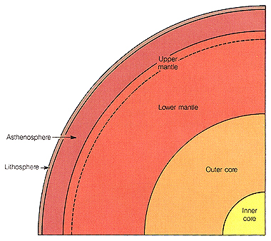
Using the geophysical evidence described above, seismic studies from observations around the world have shown unequivocally that Earth has a concentric structure as idealized in Figure 8.3. Each major unit differs in density, rigidity, thickness and composition. The main divisions are (1) the core, (2) the mantle, and (3) the crust.
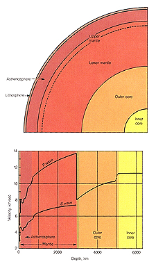
The core of Earth is a central mass about 7000 km in diameter. Its density increases with depth but averages about 10.78 g/cm3. It is nearly twice as dense as the mantle, and though it constitutes only 16 percent of Earth's volume it accounts for 32 percent of Earth's mass. Most scientists believe that the core is mostly iron and that it consists of two distinct parts---a solid inner core and a liquid outer core. Note in Figure 8.2 that S waves, which will not be transmitted through a liquid, terminate at a depth of 2900 km, and the velocity of P waves is drastically reduced at this level. This is the boundary between a liquid outer core and the surrounding mantle. Heat loss from the core and the rotation of Earth probably causes the liquid core to circulate, and its circulation generates Earth's magnetic field.
The next major structural unit of Earth, the mantle, surrounds or covers the core. This zone constitutes the great bulk of Earth (82 percent of its volume and 68 percent of its mass). The mantle is composed of iron and magnesium silicates. Indeed, fragments of the mantle brought to the surface by volcanic eruptions demonstrate that peridotite, an olivine-rich rock, is an important rock type in the mantle. Within the upper part of the mantle is a weak asthenosphere, which may extend to a depth of as much as 250 km thick, with an upper boundary 10 to 100 km below Earth's surface. Earth's asthenosphere is much closer to the surface of the planet than those presumed to exist for Mars and Mercury. The asthenosphere is distinctive because its temperature and pressure are such that it is near the melting point. In fact, it may be partly molten and structurally weak and thus flow is enhanced. Earth's asthenosphere corresponds to a seismic low-velocity zone (Figure 8.2). The lithosphere is decoupled from the rest of the deeper mantle. Movement of lithospheric plates is allowed by this layer and these movements are in turn responsible for the volcanic activity and crustal deformation observed at the surface of Earth. As discussed in the last chapter, the presence of this shallow asthenosphere may be one of the major differences between Earth and Venus.
The mantle (and overlying crust) above the asthenosphere make up Earth's lithosphere. The lithosphere is defined by its distinctive mechanical behavior. It is a rigid, solid layer about 10 to several hundred kilometers thick, which rests upon the weak partially molten asthenosphere. The boundary between the rigid lithosphere and the soft asthenosphere is gradational. The boundary between the two layers represents a change in physical properties as the mantle approaches its melting point.
As for other planets, the term crust refers to the chemically distinctive outermost layer of Earth. Today, the term designates the outer layer of Earth extending from the solid surface down to the first major discontinuity in seismic-wave velocity in the lithosphere, which heralds a compositional change. The crust-mantle boundary should not be confused with the lithosphere-asthenosphere boundary. The crust of the continents is distinctly different from the crust beneath the ocean basins. The continental crust is much thicker (as much as 50 km thick) and is composed of relatively light granitic (high SiO2) rock that includes the oldest rock of the crust. By contrast, the oceanic crust is only about 8 km thick and is composed of basalt and gabbro (low SiO2), igneous rocks having densities much greater than granite. The oceanic crust is young and relatively undeformed by folding. The differences between the continental and oceanic crust, as we shall see, are of fundamental importance in understanding Earth.
The near surface of Earth is composed of four complex geologic components, the atmosphere, hydrosphere, lithosphere, and biosphere. They are the result of continuing planetary differentiation. Each is a more or less continuous envelope or shell, wrapping around and mixing with the others. The atmosphere, hydrosphere, and lithosphere are similar in many ways to those found on some of the other inner planets; however, Earth alone developed a distinctive biosphere, which has had a dramatic effect on the other spheres.
Perhaps the most conspicuous features of Earth as seen from space are the brilliant white swirling clouds of the atmosphere (Figure 8.1). Although this envelope of gas constitutes an insignificantly small fraction of the planet (less than 0.01 percent of the mass), it is particularly significant because it moves easily and is highly reactive. It plays a part in the evolution of most features of the landscape, and is essential for life. On the scale of the illustration in Figure 8.1, most of the atmosphere would be concentrated in a layer as thin as the ink with which the illustration is printed. As far as we know, all of the life in the solar system exists within this thin film.
It has long been recognized that atmospheres surrounding planetary bodies are highly variable, ranging from the gigantic spheres of gas that constitute the bulk of the outer planets (Jupiter, Saturn, Uranus, and Neptune) to the dense atmosphere of Venus and the thin, tenuous atmosphere of Mars. These variations are so great that it seems certain that atmospheres, regardless of their origins, undergo considerable evolution through the history of the solar system.
Earth's atmosphere consists almost entirely of nitrogen (78.08 percent), oxygen (20.95 percent), and argon (0.93 percent). A fourth major component, carbon dioxide, which is essential to all plant life, is present only to the extent of about 0.032 percent. The gases are most dense near sea level and thin rapidly at higher altitudes. At a distance of 5000 km there is still a trace of an atmosphere, but it is extremely tenuous. The very outer realm of the atmosphere is represented by the magnetosphere, a zone of magnetically trapped particles. This part of the atmosphere is a powerful shield from damaging radiation that comes from outer space.
From a geologic point of view, the most significant part of the atmosphere is the lower 13 km. This zone contains about 80 percent of the mass of the atmosphere and practically all of the water vapor, as well as clouds. It is the zone in which evaporation, condensation, and precipitation occur, pressure systems develop, and decay and weathering of the solid surface rock takes place.
The atmosphere is in constant motion; the circulation patterns are clearly seen in Figure 8.1 by the shape and orientation of the clouds. At first glance, the patterns may appear confusing, but upon close examination we find that they are well organized. If we smooth out the details of local weather systems, the global atmospheric circulation becomes apparent. Solar heat, the driving force of atmospheric circulation, is greatest in the equatorial regions, and causes water in the oceans to evaporate and the moist air to rise. The warm, humid air forms an equatorial cloud belt, bordered on the north and south by relatively high-pressure zones that are cloud-free in the middle latitudes, where air descends. At higher latitudes, low-pressure systems develop where the warm air from the low latitudes meets the polar fronts. The pattern of circulation is around the resulting low pressure and produces counterclockwise winds in the northern hemisphere (Figure 8.1).
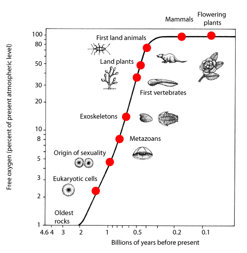
Earth's atmosphere is unique among all others in the solar system in that one of its most important constituents is maintained only by the continuous action of living things. As noted earlier, it is composed primarily of nitrogen and oxygen. These gases are merely traces in the atmospheres of most other planetary bodies (e.g., Mars); if life on Earth were to suddenly cease, significant changes in the atmosphere would certainly occur. For example, most of the oxygen continually produced by plants would soon combine with the iron and carbon in the rocks of the crust. Earth's primeval atmosphere was radically different than the present. It probably formed as a result of planetary differentiation and consisted chiefly of a mixture of carbon dioxide (CO2), molecular nitrogen (N2), and water vapor (H2O), with only small amounts of carbon monoxide (CO) and molecular hydrogen (H2). These gases were probably extruded from Earth's interior by volcanic processes resulting from the heat produced by accretion and by the decay of radioactive elements. (It is unlikely that Earth's atmosphere was trapped from the solar nebula, as appears to have been the case for the giant outer planets.) However, the composition of this early atmosphere was not static (Figure 8.4). Small quantities of free oxygen (O2) may have been produced by the decomposition of water in the upper atmosphere but most oxygen rapidly combined with rock materials or other gases. Some hydrogen probably leaked out into space and a significant amount of carbon dioxide was removed from the atmosphere to form carbonate minerals such as calcite (CaCO3) and dolomite (CaMg(CO3)2) during weathering of rocks. It seems probable that all of Earth's water was originally in its atmosphere, but as the surface cooled, most of the water vapor eventually condensed as a liquid and collected forming ancient oceans. Within these oceans the chemical differentiation of Earth continued and the first simple forms of life appeared, probably about 3 billion years ago. Using energy from the Sun, organisms that consumed carbon dioxide and released oxygen (by a process called photosynthesis) eventually evolved, and by about 2 billion years ago were producing oxygen at a rate faster than it could be removed from the atmosphere by chemical reactions with rocks. Some of the extra oxygen combined with carbon monoxide to form carbon dioxide or with hydrogen to form water. Thus the atmosphere gradually became more oxidizing. Free molecular oxygen accumulated in the atmosphere and a protective ozone layer developed. This dramatic change in the composition of the atmosphere is reflected in the rock record (Figure 8.4). In the presence of an atmosphere free of molecular oxygen, iron is relatively soluble and must have accumulated in Earth's oceans. However, iron is relatively insoluble in the present ocean because it reacts with oxygen from the atmosphere to form hematite (Fe2O3) or other iron minerals that are stable in the presence of oxygen. During the transition from an oxygen-poor to an oxygen-rich atmosphere (about 2.2 to 1.6 billion years ago), large quantities of iron were removed from the oceans to form extensive deposits of delicately banded iron-rich sediments (called banded iron formations). These sedimentary accumulations of iron are the major minable source of iron on Earth. In a sense, Earth's oceans rusted. As the atmosphere remained rich in oxygen, iron was no longer as soluble in terrestrial water. Consequently, iron-rich sediments were rarely produced after this epoch.
An equally important change in the atmosphere--ocean system is reflected by the deposition of carbonate sedimentary rocks (mostly limestones) in the oceans. The formation of these rocks removed a vast amount of carbon dioxide from Earth's atmosphere by biologic and inorganic processes. In fact, if there were no carbonate sedimentary rocks, Earth's present atmosphere would be about as dense as the atmosphere of Venus, which exerts a pressure about 90 times as great. The vast layers of limestones on the continents can be considered as a fossil segment of the early atmosphere. The removal of carbon dioxide increased the proportion of nitrogen, which is nearly inert, in the atmosphere. Thus, the evolution of life created dramatic changes in the composition of the atmosphere by introducing molecular oxygen and extracting carbon dioxide. These processes are reflected in the changing nature of the rock record with time.
If we chose one thing to distinguish Earth from other planetary bodies in the solar system, it would be the great volume of liquid water called the hydrosphere. When Earth is viewed from space, the bright blue oceans are one of the most striking features of the planet. Mars, Venus, Jupiter, Saturn and other planetary bodies have clouds, but only Earth has oceans of water and can accurately be called the Blue Planet. Today approximately 71 percent of Earth's surface is covered with water, and during some periods of the geologic past only 15 percent of the planet was dry land.
The existence of liquid water on the planet Earth is made possible by many factors. First, it is important that Earth contained a significant proportion of volatile elements when it formed---implying that some of its constituent planetesimals formed at some distance from the early Sun where temperatures were low enough for volatile compounds to form. Second, these volatile elements needed to be released from the deep interior as the silicate rocks that originally contained them dehydrated as a result of heating during planetary differentiation. Another critical factor is the position of the orbit of Earth around the Sun. Earth is just the right distance from the Sun for liquid water to exist. If it were farther from the Sun, water would be frozen on the surface, the continents would be covered with glaciers like those on Antarctica, and the oceans would be frozen solid. If it were closer to the Sun, the oceans would evaporate and Earth would become an arid inferno like Venus. Also, plant life evolved at a critical time and absorbed some of the original carbon dioxide from the atmosphere, forestalling the runaway greenhouse effect that now exists on Venus. Thus, the original composition, thermal history, and position of the Earth's orbit are in a critical balance which permits water to coexist on the surface as gas, liquid, and solid.
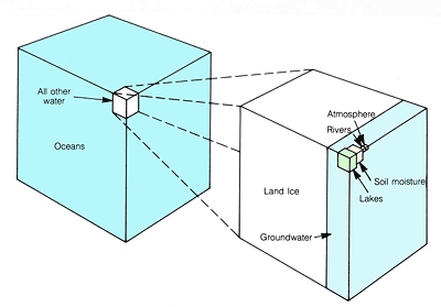
The hydrosphere contains all the free water of the planet; it includes not only the oceans, but all the water in lakes and rivers on land, groundwater beneath the surface, and the water in the glaciers. The total volume is estimated to be 1.5 billion cubic kilometers. If Earth were a smooth sphere, the water in the oceans would cover the entire planet to a depth of approximately 2700 m. The distribution of water on Earth is illustrated in Figure 8.5. About 97.3 percent of all the water in the hydrosphere is in the oceans (liquid salt water and frozen fresh water). The greatest part is in the southern hemisphere. The remaining 2.7 percent of Earth's water is on the continents, mostly in the glaciers of Greenland and Antarctica. The amount of water locked up in polar glaciers is impressively large, totaling 1.8 percent of all the water in the hydrosphere. The distribution of water upon the continents has changed with time. For example, during the recent periods of maximum glaciation much more water occurred as ice on the land, and sea level was lowered by as much as 140 m. The atmosphere contains only a mere 0.001 percent of the total water in the hydrosphere. Although this is a very small fraction of the total, the influence of this small amount on the evolution of the landscape, climate, and life is far out of proportion to its mass.
One of the most important aspects of the hydrosphere is that its constituents are in constant motion. Water moves in the major ocean basins by current systems. It evaporates and becomes part of the general circulation of the atmosphere. It precipitates and moves over the surface of the continents in river systems and percolates through the pore space of the rock and soil as groundwater. This motion makes the surface of Earth one of the most dynamic surfaces of solid planetary bodies.
The biosphere is an interwoven web of life that covers our planet. It includes the forests, prairie grasses, and the familiar animals of the land, together with the numberless creatures that inhabit the sea and atmosphere. Other planetary bodies are chemically differentiated into cores, mantles, crusts, and atmospheres, but only Earth has a biosphere. The biosphere is that part of the differentiated Earth that consists of self-replicating molecules, a property we call life. The biosphere arose and continues to evolve as part of the progressive differentiation of Earth. As a terrestrial envelope, the biosphere is discontinuous and has an irregular shape. It exists within, and reacts with, the atmosphere, hydrosphere, and the upper part of the lithosphere. In vertical dimensions the biosphere extends from the deep sea trenches of the ocean floor (more than 11,000 m below sea level) to at least 10,000 m above sea level, where spores and bacteria float high in the atmosphere. In lateral dimensions, the biosphere covers the globe, although in the hottest deserts and polar regions and at high elevations only dormant spores and other microorganisms may be found. If the biosphere were spread out evenly over Earth's surface it would only form a layer about 10 cm thick, a mere film compared to Earth's mantle, lithosphere, hydrosphere, and atmosphere. However, the biosphere is not distributed evenly over Earth but is concentrated in various environmental niches. Most of the mass in the biosphere, by far, exists in a narrow zone extending from the depth to which sunlight penetrates the oceans (about 200 m) to the snow line in the tropical and subtropical mountain ranges about 6000 m above sea level. It is obvious in space photographs as a green mat of forest in the tropical zones.
The biosphere consists of about one and a half million described species and perhaps more than twice that number yet to be discovered. Each species lives in its own distinctive niche and functions in its own specific way. Yet all living things are linked together with the inanimate part of the planet into the global ecosystem comprising the entire living space of Earth and all the life within it.
Chemically, the biosphere is constructed of only a few elements. Basically it consists of the relatively volatile elements carbon, hydrogen, and oxygen, with smaller amounts of phosphorus, nitrogen, sulfur, and iron. By far the most abundant single substance in the biosphere is water. With energy drawn from the Sun, the biosphere exchanges chemically within itself and also with the atmosphere, hydrosphere, and lithosphere.
The importance of the biosphere is not limited to its uniqueness. Although the biosphere is relatively small compared to the other major layers of Earth, it has been, and continues to be, a major geologic force operating at the surface. Few people are fully aware of the fact that not only does our atmosphere permit life to flourish, but that the oxygen in the atmosphere was produced by the chemical activity of organisms. The composition of the oceans is likewise affected by the activity of organisms, in that most marine organisms extract calcium carbonate from seawater to make their shells and hard parts. When the organisms die, their shells settle to the sea floor and accumulate as beds of limestone. The continued extraction of carbon dioxide to form calcium carbonate in the ocean has a major effect upon the composition of atmosphere as well. In addition, all of the coal, oil, and natural gas (methane) in Earth was formed by the biosphere; so large parts of the near-surface rocks in Earth's crust originated in some way from organic activity.
The record of the evolution of Earth's biosphere is preserved, sometimes in remarkable detail, by fossils, which occur in most sedimentary rocks. Indeed, the numbers of living species represent only about one-tenth of the number of species that may have existed since life first developed on Earth. The oldest sedimentary rocks known on Earth contain chemical hints that life had already made its appearance before these rocks were metamorphosed 3.8 billion years ago. Rocks as much as 3.5 billion years old bear visible structures (stromatolites) thought to have been formed by primitive forms of life.
An important, but exceedingly difficult question, remains. Are we alone? Did life of any kind arise elsewhere? We have no evidence that life exists anywhere in the solar system or elsewhere in the galaxy, even though it seems reasonable to expect that environments similar to those on Earth exist on other planets revolving about other stars. In fact, recent surveys seeking radio transmissions from advanced civilizations have found none. These searches use radio telescope dishes to look at specific signals beamed toward Earth.
In contrast to the inner planets we have studied thus far, Earth's lithosphere is relatively thin (10-200 km thick). Moreover, it is broken into a number of large fragments or plates, each of which is in motion, and much of the planet's geological activity (earthquakes, crustal deformation, and volcanism) occurs along plate margins.
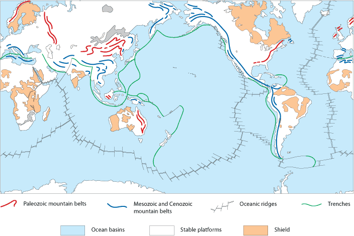
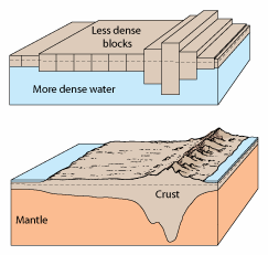
Earth's lithosphere is divided into two principal regions---continents and basins (Figure 8.6). These major divisions differ markedly, not only in elevation, but also in geologic history, rock types, age, density, and chemical composition. Oceanic lithosphere covers 60 percent of Earth and harbors a variety of spectacular landforms, most of which are due to extensive volcanic activity and movements of the lithosphere that continue today. The surface of the continental lithosphere rises above the ocean basins as large platforms. The present shoreline, which is so important geographically and has been mapped in great detail, has fluctuated greatly throughout Earth's history and has no great structural significance. The fact that the continents rise almost 5 km above the ocean basins is much more significant than the position of the shore. The difference in elevation between continents and ocean basins represents a fundamental difference in rock densities in the two types of lithosphere. Rocks of the continents have a lower density than rocks of the ocean basins. It is this density difference that causes the continents to rise and float higher than the denser oceanic crust.
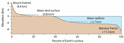
The elevation and area of the continents and ocean basins have been mapped with precision and the data may be summarized in various forms. The data presented graphically in Figure 8.7 show that the continents have a mean elevation of 840 m above sea level, and the ocean floor has a mean depth of about 3700 m below sea level. Only a relatively small percent of Earth's surface rises above the average elevation of the continents or below the average depth of the ocean floor. Figure 8.7 shows that the ocean basins are not only larger than the continental platforms, but the average depth of the ocean floor is greater than the average height of the continents.
The broad continental platforms, which rise above the ocean basins, present a great diversity of surface features, with an almost endless variety of hills and valleys, plains and plateaus, and mountains. From a regional perspective, however, the continents are remarkably flat. Most of their surfaces lie within a few hundred meters of sea level. Extensive geologic studies during the past hundred years have revealed several striking facts about the continents. 1. Although each may seem unique, all continents have three basic components: (a) a shield, (b) a stable platform, and (c) folded mountain belts. Geologic differences between continents are mostly in the size, shape, and proportions of these components. 2. Continents consist of granitic rocks, which are less dense than the basaltic rocks that form the ocean basins. 3. The continental rocks are old, some as old as 3.8 billion years. 4. Most of the continental rocks have been extensively deformed by horizontally directed compressive forces.
Shields. The continental shields are a key to understanding the origin and evolution of continents. One of the most striking characteristics of shields is that they constitute vast expanses of low, relatively flat terrain (Figure 8.8). Throughout an area of thousands of square kilometers, this surface lies within a few hundred meters of sea level. The only features that stand out in relief are resistant rock formations that rise a few tens of meters above the surrounding surface.
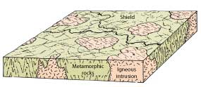
A second fundamental characteristic of shields is their structure and composition. Shields are composed of highly deformed sequences of metamorphic rocks and granitic intrusions originally formed under high temperature and high compressive stresses several kilometers below the surface. Their structural complexities are shown by patterns of erosion, the alignment of lakes, and differences in the tones of the photographs. Faults and fractures resulting from crustal deformation are common. They are expressed at the surface by linear depressions, some of which can be traced for hundreds of kilometers. The degree of compression and deformation is illustrated in Figure 8.8. Metamorphic rocks appear in tones of dark green. Granitic intrusions, which appear in lighter tones (pink), have a more massive texture; some of them cut the regional structural fabric of the metamorphic rock. It is apparent from this photograph that the original sedimentary and volcanic rocks that now make up the metamorphic rocks have been intensely deformed by compression and subsequently intruded by granitic magmas. Erosion has since removed the upper cover of the sedimentary and metamorphic terrain, exposing what we now see at the surface.
Rocks of the shield are the oldest rocks exposed in Earth's crust, some having formed more than 3.8 billion years ago. Almost all are more than a billion years old. Yet all evidence of the early period of intense bombardment, which is so prominent on the surface of the Moon, has been erased. At one time, Earth must have been saturated with impact craters like those on the lunar highlands. They have since been completely obliterated by erosion and crustal deformation. This single obvious fact sets Earth apart from most other bodies in the solar system. Earth's crust has been extremely mobile throughout geologic time, being reshaped by both erosion and deposition at the surface and by crustal deformation. Thus, from a planetary perspective, the shields are of great interest because their deformational features demonstrate this tremendous mobility of Earth's lithosphere.
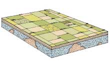
Stable Platforms. Large areas of igneous and metamorphic rocks, like those exposed in the shields, are covered with a veneer of sedimentary rocks. These areas have been relatively stable throughout the last 600 or 700 million years. That is, they have never been uplifted a great distance above sea level or submerged far below it, hence the term stable platform.
Stable platforms form much of the broad, flat lowlands of Earth and are known locally as plains, steppes, and low plateaus (Figure 8.9). Although locally the capping sedimentary rocks appear almost perfectly horizontal, on a regional basis they are warped into broad, shallow domes and basins many kilometers in diameter. One large basin covers practically all of the state of Michigan. Another underlies the state of Illinois.
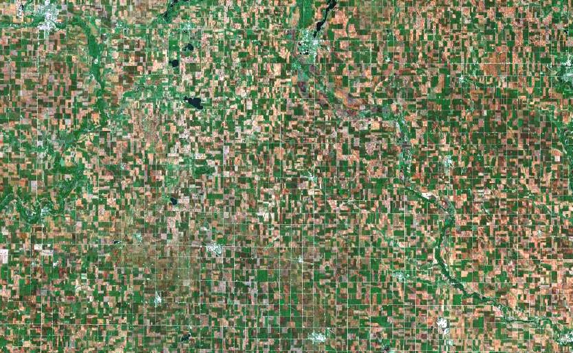
The relatively flat-lying sedimentary rocks that cover parts of the underlying igneous and metamorphic terrains are predominantly sandstone, shale, and limestone, which were deposited in ancient shallow seas. These flat-lying marine sediments, preserved on all continents, show that large areas of the shields have periodically been flooded by the sea and have then reemerged as dry land. At present, more than 11 percent of the continental crust is covered with water. At various periods in the past, however, shallow seas spread over a much greater percentage of the land surface, forming platforms covered with sedimentary rocks.
Folded Mountain Belts. Some of the most revealing features of the planet Earth are the young, folded mountain belts, which typically occur along the margins of continents. Most people think of a mountain as simply a high, more or less rugged landform, in contrast to flat plains and lowlands. To a geologist, the term mountain belt refers to a long, linear zone in Earth's crust where the rocks have been intensely deformed by horizontal stresses and generally intruded by magmas, which cool and crystallize to form batholiths. The topography can be high and rugged, or it can be worn down to a surface of low relief. It is not the topography of mountain belts that is geologically important but the extent and style of deformation.
Figures 8.10 and 8.11 illustrates some of the characteristics of folded mountains and the extent to which the margins of continents have been deformed. The layers of rock shown in this photograph have been deformed by compression and are folded like wrinkles in a rug. Erosion has removed the upper part of the folds, so the resistant layers from zigzag patterns are similar to those that would be produced if the crests of wrinkles in a rug were cut off.
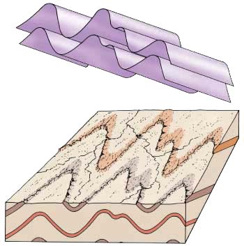
(B) A zigzag pattern at the surface is formed by the traces of the individual layers if the top of the folded sequence of rock is eroded away. Rock units that are resistant to erosion form ridges and nonresistant layers erode into linear valleys.
In many segments of folded mountain belts the intense compressional forces exceed the strength of the rock, and rupture occurs, producing thrust faults in which one block is thrust up and over the other. Movement on a thrust is predominantly horizontal, and displacement can be more than 50 km. Folded mountain belts, like the shields, therefore provide vivid evidence of the great mobility of Earth's lithosphere. Compressive stresses on the Moon, Mercury, and Mars formed the much smaller wrinkle or mare ridges which appear to be the surface expressions of thrust faults. Nonetheless, the lithospheres of these bodies have remained relatively undeformed throughout their histories. This fact is clear because nearly all of their impact craters (regardless of their age) are circular, and thus have not been deformed by compressive forces. The lithospheres of these planets, unlike that of the Earth, appear to have been fixed and immovable.
The young, active mountain belts of today are (1) the Cordilleran Belt, which includes the Rockies and Andes of North and South America, and (2) the Himalayan--Alpine Belt, which extends across Asia and western Europe. They coincide with zones of intense earthquake and volcanic activity. Older mountain ranges in which deformation ceased long ago include the Appalachian Mountains of the eastern United States, the Great Dividing Range of eastern Australia, and the Ural Mountains of Russia.
The location of young mountains in long narrow belts along the margins of continents is significant because it indicates that Earth's mountain ranges could not result from a uniform planet-wide force evenly distributed over Earth, such as one that might be produced from contraction of the planet as it cooled. Mountain ranges must be the result of forces concentrated along the margins of continents. Another important aspect of their restricted location is that many mountain belts extend to the ocean and abruptly terminate at the continental margin. This suggests that some of the older mountain ranges, including the Appalachian Mountains and the mountains of Great Britain, were once connected and have been separated by continental drift and the formation of a younger ocean basin between them.
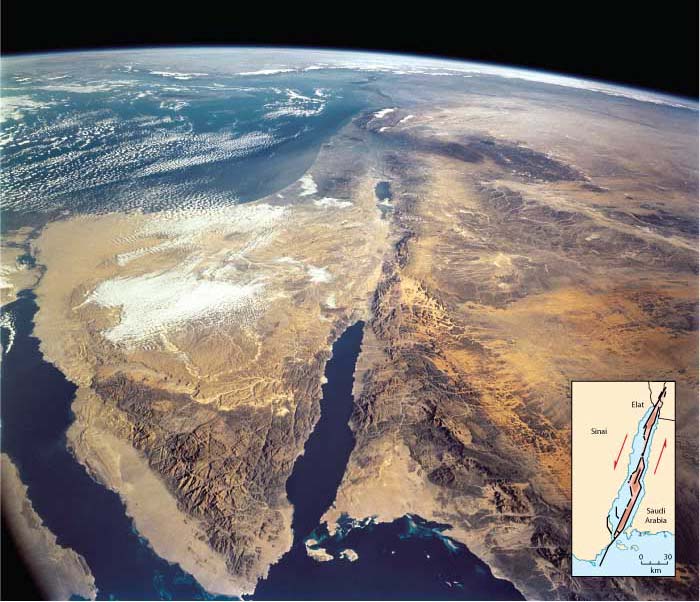
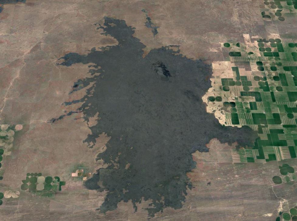
Continental Rift Systems. Several continents show evidence that certain zones are under tensional stresses and are being pulled apart. These zones are called rift systems and form part of the major tectonic pattern of Earth. Well-known examples are the East African rift system, the Rhine graben in Germany, the Baikal rift in the Soviet Union, and the Basin and Range province in the western United States (Figure 8.12).
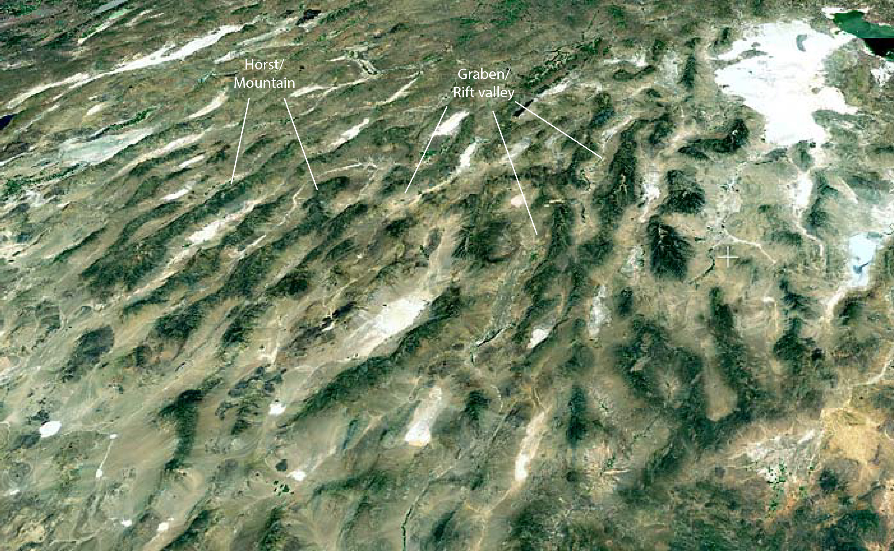
Rift systems have a series of long, nearly parallel faults that have large vertical displacements. Typically, an elongate block of the crust subsides between the faults to create a depression called a graben or rift valley. Rift valleys are generally fairly straight for long distances or form a zigzag pattern.
An important feature of rift valleys is that they follow the crest of long, broad upwarps in Earth's crust. The regional upwarping is commonly associated with the stretching and thinning of the lithosphere as hot mantle material rises upward. Young rift zones are commonly associated with active basaltic volcanism.
Rift systems are not restricted to the continents. Some of the continental rift systems seem to be extensions of oceanic ridges. This suggests that there is a planetwide rift system where Earth's crust is under tension and is being pulled apart.
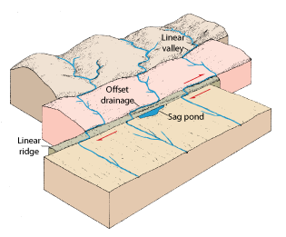
Continental Strike-Slip Fault Zones. In places Earth's crust is fractured and displaced horizontally along linear fault zones. These strike-slip fault zones are produced when large segments of the lithosphere slide laterally past one rather than colliding (Figure 8.13). The most active are the Dead Sea zone, the San Andreas fault zone in western United States, the Alpine fault in New Zealand, the Altyn Tagh fault in China, and the Anatolian fault in Turkey. These strike-slip fault zones are marked by sets of nearly vertical faults with horizontal displacements of as much as several hundred kilometers.
The ocean floor, not the continents, is the typical surface of the solid Earth. It is the ocean floor that holds the key to the evolution of Earth's lithosphere. From a variety of remote-sensing instruments, we have surveyed the ocean floor and have found that the oceanic lithosphere is completely different from the continents.
Among the most significant facts we have learned about the oceanic crust are the following: 1. The oceanic crust is mostly basalt (and its intrusive equivalents), which is erupted at an oceanic ridge. 2. The rocks of the ocean floor are young in a geologic time frame. Most are less than 150 million years old, whereas the ancient rocks of the shields are 700 million to 3.8 billion years old. 3. In general, the rocks of the ocean floor have not been deformed by compression. Their undeformed structure stands out in marked contrast to the complex deformation of rocks in the folded mountains and shields of the continents.
Although most of the topography of the ocean floor can be seen only indirectly, deep-diving research vessels have photographed local areas of the oceanic ridge. Some ocean floor features are visible using satellite measurements (Figure 8.14), but data from seismic profiles such as the examples shown in Figure 8.15 provide more detailed views of the sea floor. From these records we are able to plot accurate depth charts and physiographic or landform maps, and study a variety of geologic features not found on the continents.
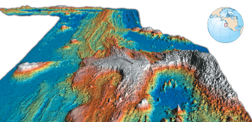
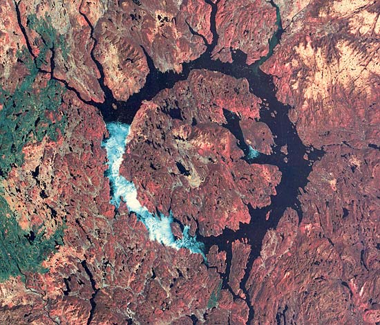
The Oceanic Ridge. The oceanic ridge is the most pronounced tectonic feature on Earth. If the ridge were not covered with water, it certainly would be visible from as far away as the Moon. It is essentially a broad, fractured upwarped segment of the crust, generally more than 1400 km wide, with peaks rising as much as 3000 m above the surrounding ocean floor. The remarkable characteristic of the ridge is that it extends as a nearly continuous feature around the entire globe, like the seam of a baseball. It extends from the Arctic basin, down through the center of the Atlantic into the Indian Ocean and across the South Pacific, terminating in the Gulf of California---a total length of more than 65,000 km. Without question, it is the greatest single structural feature on Earth.
The oceanic ridge is broken by numerous faults, which form linear hills and valleys. The highest and most rugged topography is located along the axis, and a prominent rift valley marks the crest of the ridge throughout most of its length. Oceanic sediments thin rapidly toward the crest.
Throughout most of its length the oceanic ridge is cut by a series of strike-slip faults, related to transform faults, that create steplike offsets of the ridge (Figure 8.16 and 8.17). Between ridge segments, these faults allow parts of the lithosphere to slip horizontally past one another. The fault zone is expressed by an abrupt, steep cliff, which in places extends even farther as a fracture zone that can be traced for several thousand kilometers.
Detailed studies of the axial zone of the mid-Atlantic ridge were made in 1974, when scientists in deep-diving vessels sampled, observed, and photographed the ridge for the first time. Without doubt, this project made some of the most remarkable submarine discoveries of modern times. The photographs show extensive basaltic lava flows, so recent that little or no sediment covers them. Numerous open fissures in the crust were also observed and mapped. In one small area of only 6 km2, 400 open fissures were mapped, some of which are as wide as 3 m. These are considered conclusive evidence that the oceanic crust is being pulled apart. The eruption of lava from these fractures, which parallel the rift valley, produces the outer layer of the oceanic crust.
Trenches and Volcanic Arcs. Deep-sea trenches are 8000 to 11,000 m deep and are the lowest areas on Earth's surface. The most striking examples of trenches occur in the western Pacific, where the trench system extends from the vicinity of New Zealand to Indonesia, to Japan, and then northeastward along the southern flank of the Aleutian Islands. Long trenches also occur along the western coast of Central America and South America, in the Indian Ocean northwest of Australia, in the Atlantic off the tip of South America, and in the Caribbean Sea.
Trenches are among the more significant structural features of Earth. Not only are they the lowest parts of Earth's surface but they are invariably associated with arcuate chains of active volcanoes, called island arcs, mountain belts, and zones of intense earthquake activity. Trenches are consistently associated with inclined zones of earthquakes, which dive beneath the volcanic chain.
Islands and Seamounts. Literally thousands of submarine volcanoes occur on the ocean floor, with the greatest concentration in the eastern Pacific. Some rise above sea level and form islands, but most are submerged and are called seamounts (Figure 8.14 and 8.16). They often occur in groups or chains (e.g., the Hawaiian islands), with individual volcanoes being as much as 100 km in diameter and 1000 m high. Islands and seamounts testify that volcanic activity is not restricted to the ridges but has occurred in various parts of the ocean basins above mantle plumes or hot spots in the mantle.
The surface features of the sea floor result from a combination of tectonic and volcanic processes and provide important clues to the thermal and dynamic processes on Earth. Similar features are not found on the other terrestrial planets, but as we will see, some have speculated that a type of terrain crudely similar to that of the ocean floor is found on Venus.
Geologists have long recognized that Earth has a source of internal energy that is manifested repeatedly by earthquakes, volcanism, and mountain building, but it wasn't until the late 1960s that a unifying theory of Earth's dynamics was developed. This theory, known as plate tectonics, provides a master plan that explains the major features of our planet (continents, ocean basins, earthquakes, mountain belts, and volcanism) as a result of the formation, cooling, and destruction of lithosphere. In addition, it explains why Earth is different from the Moon, Mars, and Mercury. The characteristics of the ocean floor, including its surface features as well as its magnetic and seismic properties, show quite clearly that Earth's lithosphere is not stationary but is actually in motion. The continents are carried on moving lithosphere and have repeatedly split, drifted apart, collided, and been sutured together in various patterns. The sea floors, in contrast, are temporary features, opening and closing as the plates move. New oceanic crust is continually being created where the plates move apart and is consumed where the plates converge.
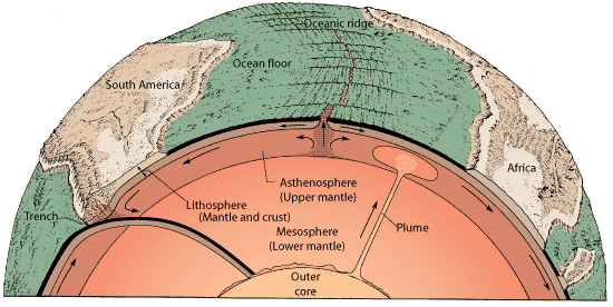
The basic elements of the plate tectonic theory are quite simple and can be understood by studying the diagram in Figure 8.16. The lithosphere of Earth is broken into a limited number of rigid plates, each of which behaves as a separate mechanical unit. The underlying asthenosphere, in contrast, yields to plastic flow. This is possible because the temperature and pressure in the asthenosphere are appropriate to melt some of the minerals, but not the entire rock. Thus, between the solid mineral grains in the asthenosphere, is molten rock material, which acts as a lubricant, somewhat like melted water in a slushy snow.
New oceanic lithosphere is constantly being created at oceanic ridges. As it moves laterally away from the ridge, the aging lithosphere cools, thickens, and becomes more dense. In fact, the oceanic lithosphere is simply the cool thermal boundary of the asthenosphere. Ultimately, as cooling oceanic lithosphere slides away from the elevated ridge, it becomes so dense that it sinks back into the mantle, pulling the rigid slab with it down a subduction zone, where it becomes a part of the mantle again. Back at the ridge, material from the asthenosphere wells upward to fill the void created by the spreading lithosphere. As this rock rises it partially melts to create basalt, which eventually cools and the lithospheric cycle begins again. As a consequence of this large-scale convection, the lithosphere is broken into a series of fragments or plates that are several thousand kilometers across (Figure 8.16).
The continents, formed of relatively light granitic rock and embedded in the denser lower part of the lithosphere, sometimes split and sometimes collide as they are carried about on lithospheric slabs. The continents do not drift through the lower lithosphere. Since Earth is a sphere, the shifting plates are often in collision with each other. As we have seen, oceanic lithosphere is consumed or recycled back into the mantle at oceanic trenches. By contrast, lithospheric plates containing light continental crust cannot sink back into the mantle. Instead, continental margins adjacent to the descending plates are deformed into linear folded mountain belts.
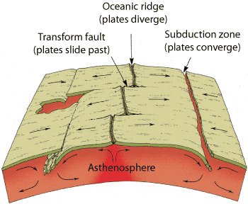
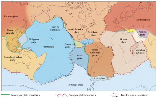
Most plate boundaries are not associated with boundaries between oceans and continents; plate boundaries coincide with ocean ridges and trenches, and are characterized by zones of earthquakes and volcanic activity. Three kinds of plate boundaries are recognized, defining three fundamental kinds of deformation and geologic activity (Figure 8.17). These boundaries, defined by the type of motion at the boundary, and called divergent, convergent, and transform plate boundaries.
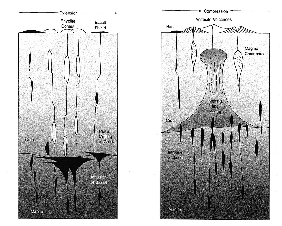
Divergent plate boundaries are characterized by tensional stresses that typically produce long rift zones in the crust, accompanied by fissure eruptions of basaltic lava. As the plate moves apart, decompression induces partial melting in the uprising mantle material, which generates basaltic magma. The magma then rises and is injected into the fissures and fractures of the rift zone; some is extruded as lava on the surface by fissure eruptions and some cools in a magma chamber beneath the surface. As the material cools, it becomes part of the separating plates. This ribbon of new material gradually splits as the plates continue to separate. Thus, new oceanic crust continually develops along divergent plate margins. About 4 km3 of new basaltic crust are generated each year along the rift zone of the oceanic ridge. The cooling of this magma is one of Earth's most important means of expelling internal heat. Where the zone of spreading intersects a continent, rifting occurs and the continent splits. The separate continental fragments drift apart with the separating plates, creating a new and continually enlarging ocean basin in the site of the initial rift zone.
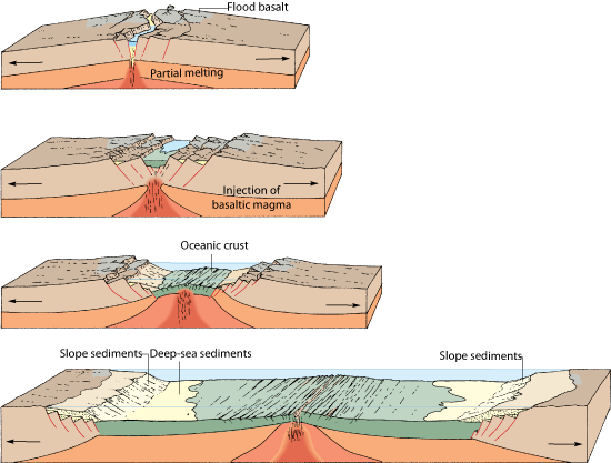
(B) Rifting continues and the continents separate enough for a narrow arm of the ocean to invade the rift zone. The injection of basaltic magma continues and begins to develop new oceanic crust (green).
(C) The ocean basin grows larger as spreading continues. The continents move off from the uparched spreading zone, and parts of the continental crust can be covered by the ocean.
(D) Eventually a wide ocean basin forms after 10s of millions of years of spreading.
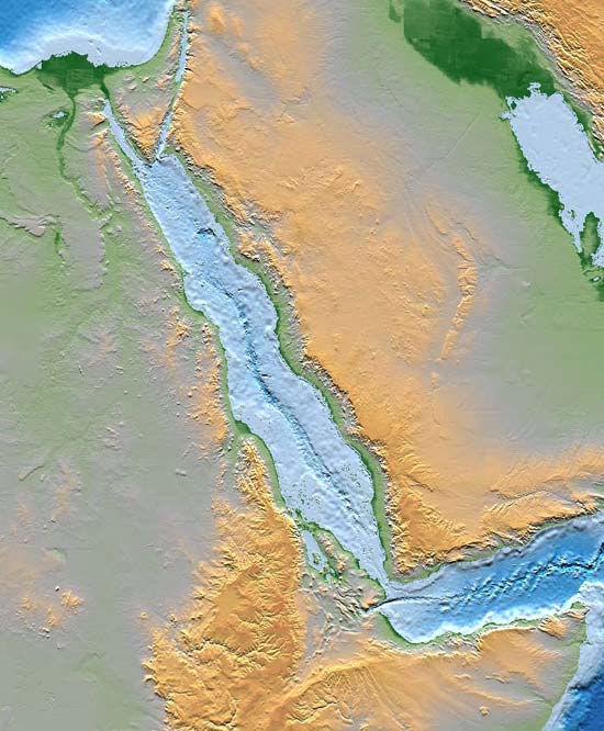
Several examples showing various stages of continental rifting and the development of new ocean basins can be cited (Figure 8.18). The initial stage is represented by the system of great rift valleys in East Africa. The long, linear valleys (which are occupied partly by lakes) are huge, down-dropped fault blocks that result from the initial tensional stress. Volcanism along the rift zone, including the great volcanoes of Mount Kenya and Mount Kilimanjaro, occurs as magma is injected into the rift zone. A more advanced stage of rifting is exemplified by the Red Sea (Figure 8.19), where the Arabian peninsula has been completely separated from Africa and a new, linear ocean basin is just beginning to develop. The Atlantic ocean represents a still more advanced stage of continental drifting and sea-floor spreading, where the American continents have been separated from Africa and Europe by thousands of kilometers. The mid-Atlantic ridge is the boundary between the diverging plates, with the American plates moving westward relative to Africa and Europe. The mid-Atlantic ridge has been intensely scrutinized in Iceland, where it rises above sea-level.
The boundary between converging plates is a zone of complicated geologic processes, which include igneous activity, crustal deformation, and mountain building. The geologic processes acting in this area depend upon the nature of the converging plates.
When both plates at the convergent boundary are oceanic, one dives beneath the margin of the other and descends into the asthenosphere, where it is heated and ultimately absorbed into the mantle. The great system of deep-sea trenches in the Pacific marks the zone where the Pacific plate descends down into the mantle. Earthquakes and volcanic activity also mark this plate boundary where the lithosphere is being destroyed.
When one of two colliding plates contains a continent, the lighter continental crust resists subsidence and always overrides the oceanic plate. The Rockies and Andes mountain chains result from the encounter of the American and eastern Pacific plates. Earthquakes that consistently rock Chile, Peru, and Central America result from the encounter of the Pacific and American plates. The active Cascade volcanoes of the northwestern United States are also related to the subduction of a small oceanic plate beneath the North American continent.
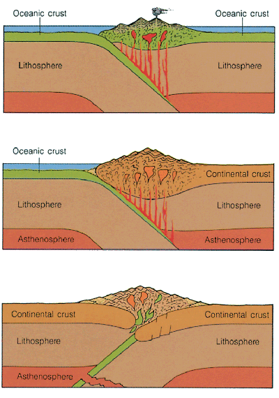
When continental crust exists on both converging plates, neither can subside very far into the mantle and both plates are subjected to compression. The continents are ultimately fused or welded together into a single continental block, and a mountain range with folds and thrust faults marks the line of suture. The deeper roots of the mountain belt become metamorphic rocks as they recrystallize under new and usually higher temperature and pressure. The Alps and Himalayan mountain systems resulted from the collision of the African and Indian plates with Eurasia, which also produces the volcanism and earthquakes that torment the Mediterranean and Near East. The nature of deformation resulting from plate collision can be clearly seen where mountain ranges have been eroded so that the resistant layers stand out in prominent relief. The radar image of part of the Appalachian Mountains in Pennsylvania is a classic example (Figure 8.10). The sequence of sedimentary rocks originally deposited in horizontal layers is now tightly folded as a result of a plate collision (between North America and Africa) more than 200 million years ago. The folds are huge flexures, which can be traced across a large part of the state by a series of zigzagging ridges. Deformation of this magnitude is produced wherever continents collide and is one of the most dramatic expressions of the tectonic system. Such folds are commonly accompanied by the development of thrust faults, similar but with more displacement than those associated with wrinkle ridges on the Moon and Mars.
The major geologic processes characteristic of converging plate margins are shown in Figure 8.20. The subduction zone (or zone of underthrusting) usually is marked by a deep-sea trench, and the movement of the descending plate generates an inclined zone of seismic activity. As the plate moves down into the hot asthenosphere, partial melting of the oceanic crust or the overlying wedge of mantle generates magma, which (being less dense than the surrounding material) moves upward. Some magma is extruded at the surface as lava flows or domes, or as ash flows. The magmas range in composition from basalt to andesite; rhyolite is important in continental volcanic arcs. These produce composite volcanoes, which form a volcanic island arc or a chain of volcanoes in the mountain belt of the overriding plate. Commonly a large part of the magma is intruded in the deformed mountain belt to form batholiths. In both cases, new, low-density material which is difficult to subduct, is added. It appears that continents grow by accretion of these marginal belts. This is an important mechanism in the differentiation of the outer part of Earth.
Because continents are never consumed into the mantle, they preserve records of plate movements in the early history of Earth---records in the forms of ancient faults, old mountain belts, granitic batholiths, and sediments deposited along ancient continental margins.
The third type of plate boundary occurs where the plates slide horizontally past each other along a special type of fault called a transform fault.
Transform faults allow two plates to slip past one another. These nearly vertical faults can join converging and diverging plate boundaries together in various combinations.
Where transform faults connect two diverging plate margins, they create a fracture zone. Fracture zones, however, are not what they might seem to be at first sight, and one must keep in mind the motion of plates produced at the spreading ridge. The apparent offset of the oceanic ridge suggests a simple (but extremely long) strike-slip fault. Careful study of Figure 8.17, however, shows that the relative motion between plates occurs in the area between ridges---the only place where the fault forms a boundary between plates. Even though the cliff, or fracture zone, persists beyond this point, the plates on either side of the fracture are moving in the same direction and at the same rate and are actually linked together (Figure 8.17).
Transform faults also can join ridges to trenches and trenches to trenches. In all cases, transform faults are parallel to the direction of relative plate motion, so there is neither divergence nor convergence along this type of boundary. As a result, plates are neither enlarged nor destroyed. The plates slide passively along the fracture system, producing only fracturing and seismic activity.
Let us consider the present structural features of Earth and how they fit into the plate tectonic theory. The boundaries of the plates are delineated with dramatic clarity by the belts of active earthquakes and volcanoes (Figure 8.21). Seven major lithospheric plates are recognized, together with several smaller ones. The oceanic ridge, where the lithosphere is pulled apart, extends from the Arctic down through the central Atlantic into the Indian and Pacific oceans. Movement of the plates is away from the crest of the ridge. For example, the North and South American plates are moving in a westward direction and are interacting with the eastern Pacific, Cocos, and Nazca plates along the west coast of the Americas. The Pacific plate consists only of oceanic crust and is moving from the ocean ridge northwestward to the system of deep trenches in the western Pacific basin.
The great central theme of the plate tectonic theory is that Earth is a dynamic planet. Although from a personal perspective, the surface of the Earth appears to be stable and unchanging from year to year, or even throughout a lifetime, it is continually being modified as heat and mass are redistributed within the planet. The footprints left on the Moon by the astronauts will remain unaltered for eons unless disturbed by a chance impact by a meteorite. The same imprints on Earth would be erased in a few hours to a few years at most, being modified by wind, running water, and overgrowth of plants, or deformed and covered by Earth movement, volcanism, or a variety of other geologic processes. Change is constant and often dramatic on Earth, in contrast to the static condition that exists on the Moon, Mercury, and most of the icy planetary bodies in the outer solar system.
In addition to the plate tectonic system there are other forces which operate upon Earth and are capable of deforming its crust. Foremost among these are (1) isostasy, (2) tidal forces, and (3) the impact of meteorites. Their influence compared to plate tectonics is minor, but some of these forces have been more significant in the past and are of paramount importance on other planetary bodies.
Isostasy. Earth's crust is continually responding to the force of gravity in an effort to reach gravitational balance or isostasy (from the Greek isos, "equal," and stasis, "standing"). Isostasy occurs because the lithospheric plates are buoyed up on the plastic asthenosphere beneath, with each portion of the crust displacing the mantle according to its bulk and density. Denser crustal material sinks deeper into the mantle than crustal material of low density.
Isostatic adjustment in Earth's crust may be thought of as though the surface layers were floating on denser material like an iceberg on the ocean. Suppose that the ice is melted by heat from the Sun only at the surface. As the upper part of the ice melts, the submerged part rises to maintain a floating balance. The same processes may be involved in Earth's crust. When weight is added in some area, such as the delta at the mouth of a river, the area subsides, displacing the subcrustal material. Similarly, as a mountain is eroded and the weight of the upper rocks removed, the area rises to compensate for the removed material.
As a result of isostatic adjustments, high mountains and plateaus usually have roots that extend more deeply into the mantle than do the roots of areas of low elevation (Figure 8.22). Any change in an area of the crust, such as removal of material by erosion or addition of material by sedimentation, volcanic extrusion, or accumulations of large continental glaciers, will cause an isostatic adjustment.
The concept of isostasy is therefore fundamental to studies of major features of the crust of all planetary bodies (not only continents, ocean basins, and mountain ranges on Earth, but rebound of crater floors and emplacement of lava flows on other planets).
Tidal Forces. Sensitive instruments capable of measuring small changes in the tilt of Earth's crust indicate that the solid lithosphere moves up and down in response to the gravitational attraction of the Moon and the Sun. During a tidal cycle, Earth's crust may move up and down as much as 30 cm. The amplitude of solid or earth tides, as they are called, is a function not only of the tide-raising force but also of the elastic properties of the lithosphere. The rise and fall of the lithosphere in response to tidal forces periodically stresses the planet but generates very little thermal energy.
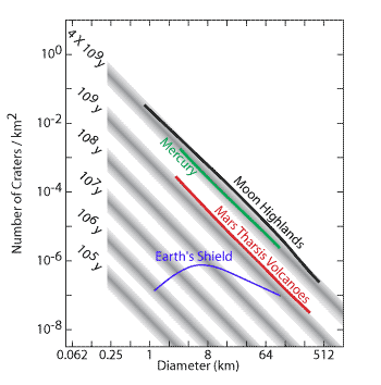
Meteorite Impact. The impact of meteorites is a fundamental and universal process in planetary development. Earth, like all of the other solid planetary bodies in the solar system, was once pockmarked with thousands of craters. The period of intense bombardment of the planets by meteorites was an early event, and the number of impacts has decreased exponentially during the last 4 billion years of planetary history. The dynamics of Earth's lithosphere and modification of its surface by erosional processes have removed most impact structures formed at that time, but over 100 craters have been identified (Figure 8.23). Most impact craters that have been found are highly degraded and lack many of the features found on pristine lunar craters (Figure 8.24). Nonetheless, even during its most recent history, Earth's surface has been modified by rare and generally small impact events.
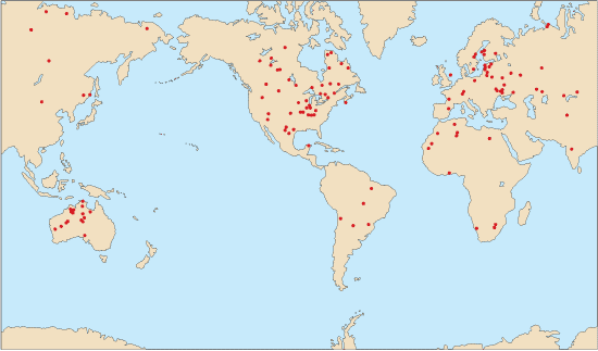
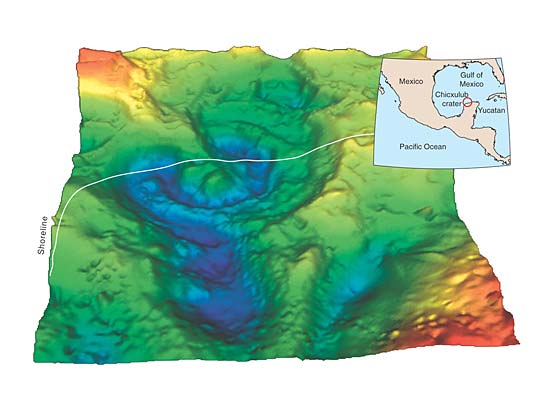
The youngest large impact crater to be identified on Earth lies on the northern tip of Mexico's Yucatan peninsula (Figure 8.25). Chicxulub crater is largely buried by young sedimentary rocks now, but small variations in the gravity field over the crater have allowed it to be detected. The crater appears to be about 200 km in diameter, but a vague outer ring may is interpreted by some to show that the crater is 300 km in diameter. If the latter estimate is accurate, Chicxulub would be larger than Meade, the largest crater on Venus. This crater is even more interesting when its age of formation is taken into account. Recent radiometric dates place it at 65 million years old, the exact boundary between the Cenozoic Era and the Mesozoic Era, the two most recent eras of geologic time. This boundary also marks the demise of some of Earth's most famous creatures, the dinosaurs. Many scientists have concluded that the impact led to the extinction of these large reptiles and to the extinction of many other forms of plant and animal life in what has been called a mass extinction. Vast amounts of dust are expelled high into the atmosphere of a planet by an impact and it is conceivable that the dust could temporarily block incoming sunlight and cool the planet. Acids are also generated from the nitrogen in the air during its heating by a meteor striking through the atmosphere. These acids may have changed the environment for many marine animals and plants. Others think that large fires may have been ignited by the impact, also adding to material in the atmosphere and blocking out solar radiation. However, the connection between impact and extinction is still being debated. Perhaps the impact was coincident with an extinction already in progress driven by changing climates and shorelines. Proponents of this idea point out that dinosaurs were showing signs of demise millions of years before the impact. Others point out that some life forms became extinct shortly before and others shortly after the impact event.
There is no more dramatic proof that Earth has an internal heat engine than the eruptions of molten rock that produce volcanoes. Volcanism is a product of the tectonic activity of Earth. Volcanic features are among the most significant landforms to be studied in planetary geology because they provide a window into the planet's interior and give tangible evidence of the processes operating far below the surface. From the studies of volcanic features, we can learn about thermal conditions below the surface, the structure of the lithosphere, and the thermal history of a planet through time. An understanding of volcanism in its broadest context is essential to understanding the origin and evolution of planetary bodies.
Earth is, and has been, far more active volcanically than one might suppose. More than 500 active volcanoes (those that have erupted at least once within recorded history) are exposed above sea level and hundreds more are considered to be inactive. In addition many thousands of extinct volcanoes have cones and craters sufficiently well preserved that they must have been active only a few thousand years ago. But these spectacular landforms tell only part of the story. Most of Earth's present volcanic activity is invisible, hidden beneath the sea. Moreover, much of the past volcanic activity on the continents is masked by a cover of sedimentary rocks or has been obliterated by erosion.
Volcanic processes require the generation of magma, its rise to the surface, and its eruption. There is a remarkable diversity in the nature of these three steps, which lead to the variety of volcanic landforms on the planets.
Magma generation requires that temperatures exceed the melting temperature of rock (for silicates 1900 to 900 K, depending on rock composition and pressure). An important reservoir of partially molten rock is the asthenosphere. In general this portion of the mantle gives rise to basaltic magma. If the fraction of melting becomes large enough, pools or pods of melt may accumulate as the liquid separates from residual crystals. Magma may escape from this residue completely if a sufficient mass of low density melt forms. Magma may rise as inverted teardrop-shaped blobs or, if it intersects a fracture, as thin streams or sheets of melt.
These magmas from the asthenosphere may in turn be heat sources for melting at shallower levels. For example, hot basaltic magma, generated in the asthenosphere, may rise into the lithosphere (the crust or upper mantle) and produce melts that may rise along separate paths to the surface or become mixed with the original magma.
Eruptions at the surface are driven by a variety of physical and chemical processes. One common method is the result of the expansion of volatile gases (mostly water or carbon dioxide) released from the magma in a process analogous to that of opening a bottle of pop to release the dissolved gas. As magmas approach the surface, the drop in pressure allows gas to separate from the liquid and to expand, sometimes explosively, fragmenting the melt and sending a shower of volcanic debris onto the surface. Other times a rising magma body encounters water near the surface (groundwater, lakes, oceans, or even glaciers), producing steam instantaneously. The conversion from liquid to steam involves a tremendous expansion and may also explosively fragment a magma and expel it from the vent.
Floods of basalts extruded as fissure eruptions are the most extensive type of volcanic activity on Earth's continents (and on the other inner planets as well). Fissure eruptions emit large volumes of very fluid basaltic lava, which fill depressions and rapidly cover broad areas with flat-lying layers of basalt flows. These volcanic extrusions do not build up high mountains, and when viewed from space they may not even appear to have a volcanic origin. Repeated eruptions flood the landscape and build up extensive plains, so that an area is completely resurfaced. Subsequent uplift and erosion causes these plains to be dissected into a series of plateaus, and these regions on Earth are referred to as basaltic plateaus.
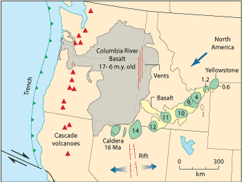
One of the most impressive aspects of flood basalts is their colossal dimensions. A lava field may cover an area of 100,000 to a million km2. For example, in southern Brazil, more than 1,000,000 km3 of basalt was extruded in a relatively short period of geologic time (10 million years). Similar floods have occurred in the Deccan Plateau of India, the Ethiopian Plateau of Africa, and large areas of Siberia, Greenland, Antarctica, and northern Ireland. Much older flood basalts are found in northern Michigan and the Piedmont region of the eastern United States. Many of these floods of basaltic lavas are related to upwelling mantle plumes. Partial melting of rising mantle results from the low pressures. Flood lavas probably record the rise of a large plume head through the mantle; the tail of the plume feeds much smaller volumes of basalt to the surface in the many hot spot tracks found on Earth.
Excellent examples of flood basalts are in the Columbia Plateau of eastern Washington and Oregon and western Idaho (Figure 8.26). The Columbia River basalts cover an area of about 200,000 km2 with a total thickness of 1 to 2 km. This great accumulation of lava flowed to the surface through numerous fissures over 100 km long. Vast dike swarms now mark these fissures. Individual flows are commonly more than 100 km long and 10 to 30 m thick. Many ponded to form large lava lakes, burying the underlying topography. In some cases a ghost or imprint of the former landscape is expressed in the surface of the flood basalts, possibly a result of differential subsidence of the lava over underlying ridges.
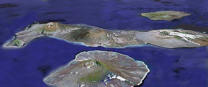
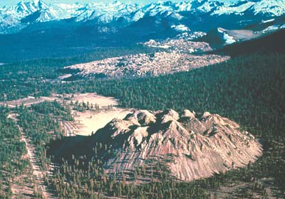
Where the rate of eruption is relatively high but the total volume of lava per eruption is low, a broad cone or mound known as a shield volcano is produced (Figure 8.27). Although fissure vents are common on such volcanoes, many eruptions are centered on pipelike conduits, which bring magma from some depth. Many shield volcanoes have summit craters or calderas produced by collapse and small cinder and spatter cones are commonly developed on the volcanoes' flanks. The Hawaiian Islands are examples of large, basaltic, shield volcanoes. The shields are commonly several kilometers high and tens of kilometers wide. Volcanic islands like Hawaii are composed of stacks of overlapping shields---five are exposed at the surface. Many other shield volcanoes dot the floors of the oceans, but large basaltic shields are less common on the continents.
Other accumulations of basaltic lavas combine features of both flood basalts (with fissure eruptions) and shield volcanoes (with central vents). These basaltic plains are typified by the Snake River Plain in southern Idaho (Figure 8.28) where small, 2 to 15 km across, and low shields, less than 100 m high, are interspersed with fissure-fed lavas. Over 300 shields are on this plain and the volume of lava extruded from each is relatively low---on the order of 1 to 5 km3. In marked contrast to flood lavas, the lava flows are usually less than 10 m thick and 30 km long. Low shield volcanoes may coalesce and form the major internal structure of a basaltic plain. Small cinder cones, as well as spatter cones, which are built entirely from spatter accumulating at the base of a lava fountain, may also be produced over some fissure eruptions. The individual flow units have a number of characteristic flow features. A typical basaltic flow will develop lobate flow fronts so that although the flow is elongate its margins are highly irregular (Figure 8.28). In many areas lava flows are confined to channels and flow as open rivers of lava. This prevents heat loss and enables the flow to remain mobile for a longer period of time. The frozen sides of a lava channel will build up from small overflow surges and spatter to form a lava levee. Commonly, the top and margins of a lava flow solidify first, leaving the interior liquid. Beneath this solid upper crust the lava will remain mobile, and if the liquid breaks through the lower end of the crust and runs out, a long lava tunnel or lava tube will form. The roof of a lava tube may subsequently collapse to form a long open trench or a series of depressions aligned in a sinuous pattern. Lava channels and lava tubes help to preserve the heat and fluid condition of a flow and thus permit it to be transported a long distance from its source. Many tube systems on Earth are over 20 km in length; on the Moon and Mars tube systems exceed 100 km in length.
The type of volcanism associated with young mountain belts and island arcs is quite different from the basaltic fissure eruptions and basaltic plains. The silicic magma is relatively cool, richer in volatile components (like water) and more viscous than basaltic magma. As a result, the mechanism of eruptions and the volcanic products are different from those associated with basaltic eruptions.
Many silicic lava flows are so thick and viscous that small volumes hardly flow at all, but form massive plugs or bulbous domes over the volcanic vent (Figure 8.29). These eruptions are generally small in volume (2 or 3 km3), but the domes may coalesce to form larger fields. Small eruptions of volcanic ash generally occur just prior to the appearance of pasty lava at the vent. Silicic lavas erupted on the continent are commonly accompanied by the formation of basaltic shields or cinder cones. In some cases the basalt seems to have added heat to the continental crust inducing the formation of silicic magma by partial melting of already silica-rich crust (Figure 8.30).
(Right) In a compressional tectonic setting, the intrusion of basalt into crust may lead to the development of an andesitic composite volcano and associated vents. In this setting basaltic magma may mix with silica-rich crustal melts to form andesite, for example. The amount of heat, the composition of the magmas, and the nature of the stress field are all controlled to a large extent by the tectonic setting of the volcanic system. Thus, it is no surprise that the style and composition of volcanic systems are related to their plate tectonic setting.
Eruptions of large volumes of silicic magma as ash, instead of lava, form broad ash-flow shields (Figure 8.31). These shields have dimensions similar to basaltic lava shields---50 to several hundred kilometers across and a few kilometers high---but represent a dramatically different eruption style. As silicic magma works its way to the surface, confining pressure is released and trapped gas bubbles rapidly expand. Near the surface, the magma explodes, ripped apart by the pressure of the rapidly growing bubbles. Towering columns of ash are propelled to heights of 20 to 30 km by expanding gases released from the magma and by the convective movements of the heated atmosphere. Showers of particles falling out of these clouds produce ash-fall blankets several meters thick near the vent. If the density of the eruption cloud exceeds the ability of the atmosphere to support it, vast quantities of still incandescent ash collapse to the ground and rush outward as ash flows. Once on the ground, these ash flows behave like fluid lavas but consist instead of jostling bits of ash lubricated by gas swallowed at the flow's front. These streams sweep over hills and travel distances of hundreds of kilometers at tremendous velocities (approaching 100 m/s or 360 km/h). Some deposits are more than 100 m thick and cover thousands of square kilometers. Although most are much smaller, some prehistoric eruptions expelled over 3000 km3 of magma in one episode. Repeated eruptions build up very large shields and eventually drain huge magma chambers. Circular calderas (large volcanic craters) form when the unsupported roof of the magma chamber collapses after the expulsion of the magma. The calderas may be up to 100 km across; some contain younger volcanic domes and thick accumulations of ash.
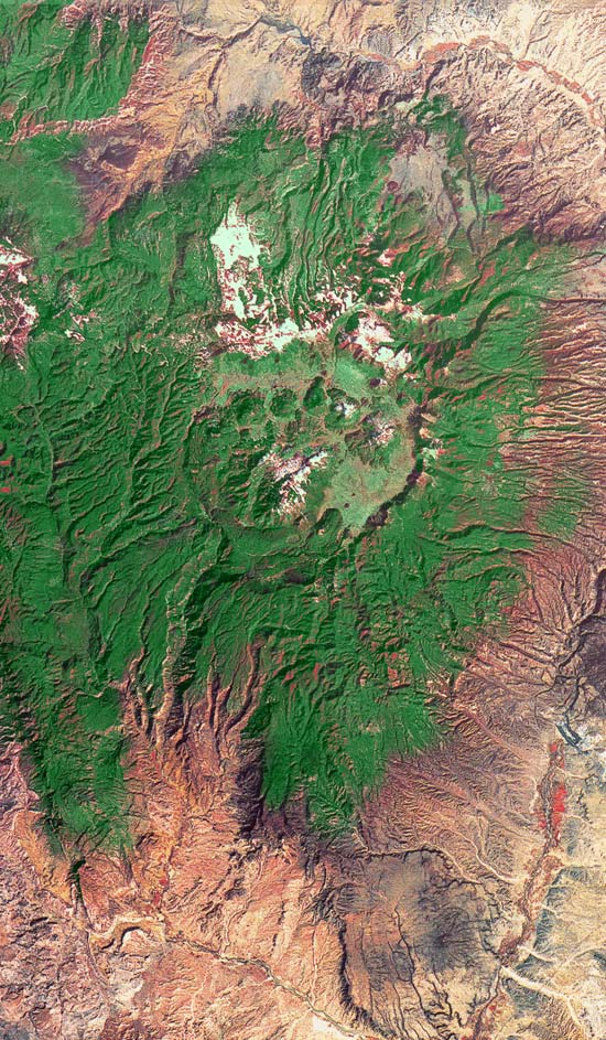
Composite volcanoes have high, steep-sided cones around their vents (Figure 8.31). They are composed of interlayered ash and viscous lava flows, combining features of lava domes and ash-flow shields. This is probably the most familiar form of continental volcano, with such famous examples as Mount St. Helens, Fuji, Vesuvius, and Etna. These cones may be 1 to 2 km high and have diameters of about 5 to 10 km. Usually, a crater at the summit marks the position of the vent. Subsidiary vents occur on the flanks and on the surrounding platforms. These vents may be marked by pluglike domes, lavas, or even cinder cones (Figure 8.33). Explosive eruptions, similar to but smaller than those that produce ash-flow shields, may cause composite volcanoes to collapse and produce calderas. Crater Lake, Oregon (Figure 8.34), formed when a volcano's summit collapsed after its last major eruption and the resulting caldera filled with water. Composite volcanoes emit many types of magma but andesite is common. Moreover, this type of volcano is typical of island arcs and volcanic arcs on the continents.
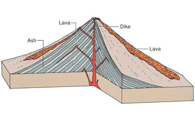
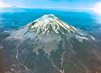
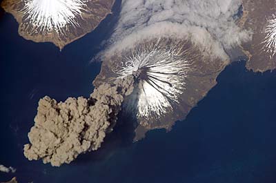
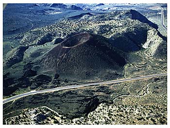
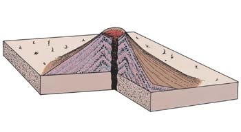
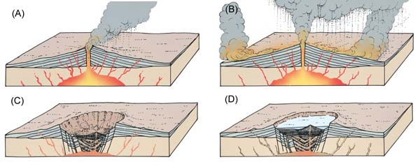
The size, shape, type of magma, and eruption style of volcanoes are governed by many factors. Three of the most important are (1) the composition of the magma, (2) the source and amount of thermal energy, and (3) the nature of stress in the lithosphere. Obviously, the composition of magma may determine whether it flows as a lava or explodes to form a gas-rich column of ash. The thermal energy in a volcanic system determines the amount of magma produced, its temperature, and the length of time the system will be active. The state of stress, extensional or compressional, is important in determining if long fissures or central conduits are formed. Extension of the lithosphere favors the production of magma-filled fractures and shortens the length of time a magma requires to reach the surface. Compression inhibits the upward movement of magma, perhaps enhancing the mixing of different magmas. These factors are summarized diagrammatically in Figure 8.30, which also serves as a reminder of the three parts of all volcanic systems---a magma source, an ascent route, and eventual eruption through a vent.
Many of the factors that govern volcanic processes on Earth are controlled by its tectonic system. The flow of energy and material in this system determines how much heat can be delivered where and also the state of stress experienced by a region. Therefore, it should come as no surprise that the different types of volcanism can be generally related to certain tectonic environments. Rifting and the production of numerous fractures is associated with the production of basaltic plains or flood basalts (depending on the volume of individual eruptions). In continental settings, silicic dome clusters or ash-flow shields are typical expressions of the accumulation of silicic melts produced by the heat from these basaltic magmas as they pass through or stall at the base of the crust. Lithospheric subduction, accompanied by compressional stress, is usually associated with the formation of composite volcanoes in island arc chains or on the continents. Magmatism associated with mantle plumes may produce huge basaltic shields in the ocean basins, or it may produce ash-flow shields and basaltic cinder cones and low shields on continental crust. The more silica-rich magmas may come from partial melting of the continental crust.
We have seen in the previous sections of this chapter that the major features of Earth (continents, ocean basins, mountain belts, volcanoes, etc.) are produced by the tectonic system. The details of sculpturing and shaping the surface of the planet, however, are caused by the hydrologic system. The hydrologic system operates on a global scale extending over the entire Earth. In the broadest sense it includes all possible paths of motion of Earth's hydrosphere (Figure 8.35). The system operates as heat from the Sun evaporates water from the oceans, the principal reservoir for Earth's water. Most of the water returns directly to the oceans as rain. Atmospheric circulation carries the rest over the continents, where it is precipitated as rain or snow. Water that falls on the land can take a variety of paths back to the oceans. The greatest quantity returns to the atmosphere by evaporation, but the most obvious return is by surface runoff in river systems that funnel water back to the oceans. Some water also seeps into the ground and moves slowly through the pore spaces of the rocks. Plants use part of the groundwater and then expel it into the atmosphere by transpiration. Much of the groundwater slowly seeps into streams and lakes or migrates through the subsurface back to the oceans. In polar regions water can be temporarily trapped upon a continent as glacial ice, but the ice in glaciers moves from cold centers of accumulation into warmer areas, where it ultimately melts, returning to the system as surface runoff.
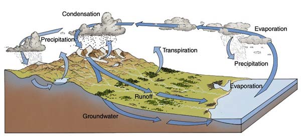
Water in the hydrologic system---moving as surface runoff, ground water, glaciers, and waves and currents---erodes and transports surface rock material and ultimately deposits it as deltas, beaches, and other types of sedimentary formations. In this way, the surface material is in constant motion, generally moving under the action of gravity from highlands toward lower regions. The movement of material by the hydrologic system is constantly resurfacing the planet. New surfaces are produced by erosion and by deposition of sediments, which cover older surfaces.
Another way to gain an accurate conception of the magnitude of the hydrologic system is to study Figure 8.1, which permits a view of the system in operation on a global scale. A traveler arriving from space would observe that Earth's surface is predominantly water. The movement of water from the oceans to the atmosphere is expressed in the flow patterns of the clouds. This motion is one of the most distinctive features of Earth as viewed from space, and it stands out in marked contrast to conditions on Moon, Mars, and Mercury.
We can also gain insight into the magnitude of the hydrologic system by considering the volume of water involved. From extensive measurements of precipitation and stream runoff, it has been estimated that if the hydrologic system were interrupted and water did not return to the oceans (by precipitation into the oceans and by surface runoff from the continents), sea level would drop 1 m per year. All of the ocean basins would be completely dry within about 4000 years. Stated another way, Earth's continents are washed by the equivalent of the whole ocean every 4000 years. The recent glacial epoch demonstrates this point clearly. The hydrologic system was partly interrupted as much of the water that fell upon the northern hemisphere froze and formed huge continental glaciers, which prevented the water from flowing immediately back to the oceans as surface runoff. Consequently, during this ice age, which ended about 10,000 years ago, sea level dropped more than 100 m.
In the following sections of this chapter we consider some of the details of how the hydrologic system operates and the surface features it produces.
The interface between the atmosphere, hydrosphere, and lithosphere is an environment of constant change for minerals and rocks. Solid rock exposed at the surface rapidly breaks down and is decomposed by weathering. Most rocks in the lithosphere were formed several kilometers below the surface and were in equilibrium at the high temperatures and pressures that exist deep within Earth's crust. Consequently, when they are exposed to the much lower temperature and pressure at the surface, to the gases in the atmosphere, and to liquid water, they become unstable, experiencing chemical changes and mechanical stresses. As a result, new minerals that are stable at the surface are formed, and solid rock is transformed into small, decomposed fragments that can be removed by agents of erosion. Water is of prime importance in chemical weathering because it takes part directly in the chemical reactions and it carries elements of the atmosphere into contact with the minerals of the rocks. In addition, water removes the products of weathering, thus exposing fresh rock. The rate and depth of chemical weathering, therefore, is greatly influenced by the amount of precipitation.
The products of weathering can be seen over the entire surface of the land, from the driest deserts and frozen wastelands to the warm, humid tropics. The major products include a blanket of loose, decayed rock debris, the regolith, which forms a discontinuous cover over solid bedrock. Earth's regolith thus has a very different origin than the impact-generated lunar regolith. The thickness of the regolith ranges from a few centimeters to many meters, depending on the climate, the type of rock, and the length of time that uninterrupted weathering has proceeded. Other major products of weathering are the soluble compounds carried away by streams and ground water. The salts in ocean water have accumulated from these weathering products.
Stream valleys are the dominant landform on Earth's continents; scarcely a landscape exists that does not have some feature produced by the action of running water in the fluvial system. An attempt to appreciate the significance of streams and stream valleys in the regional landscape of Earth, however, is a problem of perspective, much like trying to appreciate the abundance of craters on the Moon from viewpoints on its surface. To an astronaut on the Moon, the surface appears to be an irregular landscape of rolling hills cluttered with rock debris. Indeed, crater rims may appear only as rounded hills. Viewed from the ground, Earth's stream valleys also appear rather nondescript and may be considered only as relatively insignificant, irregular depressions between rolling hills, mountains, and broad plains. But viewed from space, stream valleys can be seen to dominate the landscape of most of Earth (Figure 8.36).
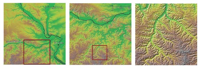
The dominance of stream valleys and associated stream deposits on Earth's continents is an expression of the importance of the hydrologic system and its control in shaping the landforms of Earth. No other planet in the solar system has a hydrosphere like Earth, and no other planet has a surface continually modified by running water.
A river system is a network of connecting channels through which water is collected and drains back to the ocean. Rivers also transport large volumes of suspended silt and mud, as is shown in Figure 8.37 The amount of the sediment load carried by a river is controlled by the velocity of the water, size of the drainage basin, elevation of the land, and climate. Maximum sediment load occurs in large rivers that drain a mountainous topography in a humid climate.
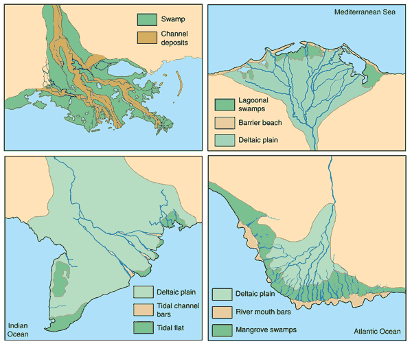
A river consists of a main channel and all of the tributaries that flow into it. Each river system is bounded by a divide (ridge), beyond which water is drained by another river system. The drainage system acts as a funneling mechanism for removing precipitation and weathered rock debris. A typical river system can be divided into two subsystems: a collecting system and a dispersing system.
The collecting system of a river, consisting of a network of tributaries in the headwater region, collects and channels water and sediment to some base level, usually the ocean. The streams commonly form dendritic (treelike) patterns with intricate systems of branches, which extend upslope toward the divide. By plotting all of the tributaries longer than 1 km in the drainage system shown in Figure 8.38, we obtain the intricate pattern shown in the enlargement. Moreover, each of the smallest tributaries shown in Figure 8.38 has its own system of smaller and smaller tributaries, so that the total number becomes astronomical. The network of tributaries is important because it is a clear expression of the fact that the main source of water in Earth's rivers is from rain and surface runoff. If the main source of water were from groundwater seepage and springs (as on Mars) or from melting of ice, integrated tributary networks would not develop. Thus, the patterns of Earth's drainage networks are a result of the nature of its hydrologic system in which there is a permanent reservoir of water (oceans) and a constant cycle of water from the oceans to the atmosphere, precipitation on the surface, and surface runoff.
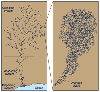
The dispersing system of a river consists of a network of distributaries at the mouth of a river, where sediment and water are dispersed into the ocean, a lake, or a dry basin. The major processes in the dispersing system are the deposition of the coarse sediment load and the dispersal of fine-grained material and river waters into the basin. Huge accumulations of sediment, called deltas, are commonly built at the mouths of major rivers where they enter the ocean.
Removal of regolith or soil is one of the most important processes of stream erosion. Loose, weathered rock debris (sand and mud) falls under the action of gravity or is easily washed downslope into the drainage system and is transported as sediment load in streams and rivers. In addition, a considerable amount of soluble material is carried in solution. As the regolith is removed, it is continually being regenerated by weathering.
Downcutting of stream channels is a second basic process of erosion in all stream channels. Hard silicate minerals carried by rivers are capable of abrading and eroding channel floors. The process of abrasion in rivers is similar to that by which the wire saws used in quarries cut large blocks of stone. An abrasive such as quartz, when dragged across a rock by a wire, can cut through a stone block with remarkable speed. And so it is with the abrasive action of a river system.
Headward erosion is the third fundamental process involved in the erosion of a stream valley, and every tributary is involved in the process. Above the head of a valley, water flows down the slope as a sheet, but it converges to a point where a definite stream channel begins. As the water is concentrated into a channel, its velocity and erosive power increase far beyond that of the slower-moving sheet of water on the surrounding, ungullied surface. Thus, the head of the valley is eroded much more rapidly than are the valley walls and the valley is extended upslope. In addition, groundwater moves toward the valley, so that the head of the valley is a favorable location for the development of springs and seeps. These in turn help to undercut overlying resistant rock and cause headward erosion to occur much faster than does the retreat of the valley walls.
In continental highlands erosion can occur at a surprising rate, and as soil and loose rock material is washed away by the system of streams and rivers, a new surface is created. On the basis of extensive sampling of sediment transported by rivers and radiometric dates of landform changes it is possible to estimate the rate of erosion over large regions. Mountainous areas are being reduced at an average rate of 50 cm per 1000 years, whereas moderately sloping surfaces (shields and platforms) are being reduced at a rate of less than 5 cm per 1000 years. An average of 15 cm of material over the entire surface of a continent is removed every 1000 years. Of course, erosion of the continents is interrupted periodically by deposition of sedimentary rocks as sea level rises or continents drop. Thus, any surface feature is a temporary thing; Earth is constantly being resurfaced by deposition and by erosion. This is certainly not the case for most planetary bodies, such as the Moon, Mercury, and the icy satellites in the outer solar system. Their landforms are mostly old fossils of the period of intense bombardment, with only parts of their surfaces being covered or eroded subsequently.
Erosion is the dominant process in the high headwaters of a drainage system; but where the stream gradient is very low, a river system is unable to transport all of its sediment load and significant deposition occurs. Sediment deposition is usually caused by a drop in velocity of the flowing water. For example, as water velocity drops along the inside of a meandering river bend, some sediment is deposited; erosion occurs on the outside of the bend, where water velocity is higher (Figure 8.36). Likewise, if a river overflows its banks during flood stage, the water is no longer confined to a channel but flows over the surface as a broad sheet. This flow pattern significantly reduces the water's velocity, and some of the sediment settles out. Natural levees grow with each flood and soon form high embankments. Thus, a river actually can build its channel higher than the surrounding area.
Another cause of stream deposition involves a large supply of sediment. A river will then deposit the excess materials on the channel floor as sandbars and gravel bars, forcing a stream to split into two or more channels, and form an interlacing network of channels and islands (Figure 8.39). Such streams are called braided rivers and bear many similarities to the dry channels found on Mars.
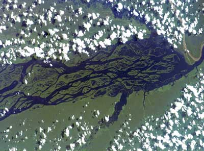
Alluvial fans are stream deposits that accumulate in dry basins at the bases of mountain fronts. An arcuate, fan-shaped deposit (Figure 8.40) results from the sudden decrease in velocity as a stream emerges from steep upland slopes and enters an adjacent basin with a gentle gradient. Alluvial fans form mostly in arid regions, where streams flow intermittently. As several fans build basin-ward at the mouths of adjacent canyons, they eventually merge to form a broad slope of alluvium at the base of the mountain range.
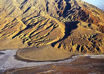
The major areas of sediment deposition, however, are the areas where rivers enter lakes or the ocean. Here the velocity suddenly diminishes, and most of the river's sediment load is deposited to form a delta. The manner in which a delta grows depends on such factors as the rate of sediment supply, the rate of subsidence, and the removal of sediment by waves and tides. If stream deposition dominates, the delta is extended seaward. If waves dominate, the sediment delivered by the river is transported along the coast and deposited as beaches and bars. If tides are strong, sediment is transported up and down the distributary channels, forming linear bars in wide distributary channels.
The great deltas of Earth are deposited by major rivers that have maximum discharge---in general, those that drain the tropical regions (Figure 8.37)---so large deltas, and the rivers that feed them, are partially controlled by climate. Some deltas cover many thousands of square kilometers and have remarkably flat surfaces, only a few meters above sea level. Indeed, large parts of most major deltas are below sea level. The rocks formed from the sediment accumulated in deltas are commonly fine-grained shales and are the most common type of sedimentary rock on Earth.
On a regional basis the drainage patterns of the major rivers of Earth reflect the regional structure and tectonic history of the continents they drain. They develop on a high mountain belt on the leading edge of a continent and flow across the shield or stable platform toward the trailing or inactive margin of the continent. This results in a distinctive asymmetry, so that the drainage pattern of an idealized major river would consist of a large collecting system in a mountain belt with a trunk stream flowing across the stable platform or shield and emptying into the sea along the trailing, or tectonically inactive, edge of the continent. The Amazon River in South America and the major north-flowing rivers in Russia are examples of this basic pattern.
Although the orientation of major river systems depends mostly on the tectonic history of the continental mass, other factors can significantly modify and alter the drainage pattern. Continental rifting will effectively behead or dismember a previously established river system. Changes in sea level can markedly alter and reduce the size of river systems and eliminate many smaller ones. Continental glaciation will completely obliterate the drainage system beneath it and force the major rivers to establish a new course along the margins of the ice. After the continental ice sheet retreats, a new and commonly complex pattern is reestablished through a system of overflowing ponds and lakes. Outpouring of flood basalts can also completely disrupt and destroy the drainage system over which they flow, and a new pattern has to be established on or adjacent to the volcanic surface. Also, as a continent drifts into an arid zone, desert sand can obliterate large parts of the previously established drainage system, as in the case of the Sahara in North Africa. The Niger River, for example, which is diverted by the Sahara Desert, makes almost a complete circle.
Two important questions concerning a river system are its age and its history, but the answers are extremely complicated. Unlike impact craters, rivers do not form instantaneously. Very few rivers (and certainly no major ones) begin or end without some relationship to the drainage systems that preceded them. Instead, a drainage system continually evolves by headward erosion and stream capture, adjustment to structure, and adjustments and modifications to marine transgressions, continental glaciation, desert sand, and continental rifting. As a drainage system evolves, each period or generation inherits something from its ancestors. The reason for continual evolution of a river system is that the hydrologic system is continuous.
The movement of water in the pore spaces of rocks beneath Earth's surface is a geologic process that is not easily observed and therefore not readily appreciated. Yet groundwater is an integral part of Earth's hydrologic system. It is distributed everywhere beneath the surface and occurs not only in humid areas but beneath desert regions, under the frozen Arctic, and in high mountain ranges. In many areas, the amount of water seeping into the ground equals the surface runoff.
Like other parts of the hydrologic system (rivers and glaciers), the groundwater system is open, with inputs, a means of transport, and places for discharge of water. However, movement in groundwater systems is generally very slow compared to the flow of water in surface streams.
Groundwater systems exist because solid bedrock, like loose soil and gravel, contains pore spaces. The pores, or voids, within a rock can be spaced between mineral grains, cracks, solution cavities, or vesicles. Water seeps into the ground, pulled downward by gravity; below a certain level, all of the openings of the rock are completely filled with water.
Groundwater returns to the surface at springs and enlarges and extends some stream valleys, as is thought to have happened in some martian valley networks. But erosion caused by terrestrial springs is not as spectacular as the great outflow channels that surround Chryse basin on Mars.
In many parts of Earth, underlain by thick layers of limestone, solution activity of groundwater has produced a spectacular and distinctive landscape called karst topography. Instead of an integrated network of stream valleys, karst topography is made of features produced by solution activity of ground-water and collapse. The most common and widespread features in karst areas are depressions called sinkholes, which develop over caves. Groundwater dissolves the rock in small cavities and fractures and enlarges them into caves and caverns. Ultimately, the roofs of these growing caves collapse, creating small craterlike depressions. In the limestone regions of Kentucky and Illinois, for example, are an estimated 600,000 sinkholes, which vary from one meter to more than 30 m in depth. Few through-flowing streams traverse karst areas. What streams do occur, disappear quickly by flowing into sinkholes. Most valleys, therefore, are short and end abruptly as the streams disappear into the subsurface.
Limestone is the most common rock type susceptible to solution in water; but dolomite, rock salt, and gypsum can also develop karst features. The great karst regions of Earth are the limestone terrains in tropical and semitropical regions where rainfall is abundant. These are shown in Figure 8.41. Regions of low rainfall are much less susceptible to karst development because there is simply not enough water to accomplish the necessary solution activity. In extremely cold climates, full development of karst topography is inhibited by the presence of permafrost. The permanently frozen groundwater does not circulate, so solution activity cannot occur. Likewise, karst terrains do not develop in the nearly insoluble metamorphic and igneous rocks of the shields. The most favorable areas for karst development are on the gently dipping limestones of the stable platforms in temperate climatic zones. China has the largest area of karst on Earth; the spectacular landscape (Figure 8.42) is well known from the classic art of southern China.
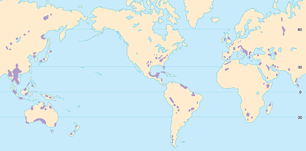
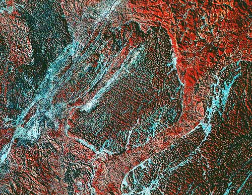
As seen from satellite photography, shorelines are one of the most obvious surface features of Earth, because of the striking contrast between the reddish land and the blue water. One might therefore suspect that the shoreline is a fundamental structural feature of Earth, but this is certainly not the case. Shorelines are temporary geographic features, changing constantly as a result of tectonic movements, wave erosion, coastal deposition, and numerous factors that cause sea level to rise and fall. Shorelines are sculptured by waves and currents into many shapes and forms---ranging from steep rocky cliffs to low beaches, quiet bays, tidal flats, and marshes.
Throughout the history of Earth, shorelines have been very temporary features, constantly changing as a result of the rise and fall of sea level. You will remember from previous descriptions of the major features of continents that the shields and stable platforms are remarkably flat surfaces eroded down to within a few hundred meters of sea level. Thus, any significant change in sea level will result in a major change in the coastline. For example, nearly all coasts on the planet today have been profoundly affected by the rise and fall of sea level caused by the ice age. During periods of glaciation, water was locked upon the land in the form of vast ice sheets. As a consequence, sea level dropped several hundred meters. When the glaciers melted, sea level rose and flooded large parts of the continents. In some places the sea has expanded more than 400 km inland from its former position only a few thousand years ago.
Indeed, one of the most significant surface processes on Earth has been the expansion and contraction of seas over nearly flat continental platforms. The result of this action has caused the platforms to be resurfaced many times, as they were covered with sediment deposited in these shallow seas. What causes sea-level change and the transgression and regression of water over the flat continental platforms? As noted above, one major cause is probably climate change driven by orbital factors (the tilt of Earth, its wobble, and the evolution of the shape of its orbit) as well as by the composition of the atmosphere (a slight increase in carbon dioxide content in the atmosphere will cause the global temperature to rise several degrees). During cold periods sea level is low, and water is trapped on the continents as ice; during warm periods the continents are flooded as the glaciers disappear. Aside from climate change, sea level changes because of the mobility of Earth's lithosphere. For example, an increase in the rate of sea-floor spreading would warm and inflate the midoceanic ridges, reducing the volume of the ocean basins. This would cause the sea to expand over low continental areas. Slow rates of convection would allow the oceanic ridge to subside, increasing the volume of the ocean basins and causing the sea to withdraw from the continents. Hot spots in the mantle beneath the continents could also cause upwarping and regression of the seas.
As a result of sea-level change, Earth's continents have been resurfaced hundreds of times as sedimentary rocks (shale and limestone) deposited in the shallow seas buried continental margins. Unlike other planetary bodies in the solar system, Earth has continually been resurfaced since it originated as a planet.
Although the liquid water of the hydrosphere is nearly pervasive on Earth, more than a third of its present land surface is arid desert in which there is little rainfall. The largest deserts are the Sahara, the Arabian, the Kalahari, and the great desert of Australia (Figure 8.43). All of these deserts lie between 10 and 30 degrees north or south of the equator. Other smaller deserts occur in the rain shadows of high mountain ranges. The most hostile of Earth's arid regions seemingly exist without a trace of precipitation and has temperatures as high as 350 K (150 F).
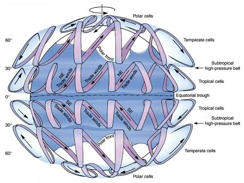
Although arid regions are characterized by low rainfall (generally less than 15 cm per year) and high rates of evaporation, climatic changes have repeatedly occurred throughout geologic time, and running water is still a dominant factor in forming much of the desert landscape. The drainage in most deserts rarely reaches the sea (the Nile and the Colorado rivers being major exceptions). That is, the rainfall is so small and the rate of evaporation so great that water does not flow out of the desert region. The result of this internal drainage is that the products of weathering (sand, silt, and loose rock fragments) are not carried out of the area but are deposited to form a variety of distinctive landforms. Sand and gravel washed down from highlands during flash floods accumulate as fan-shaped deposits in adjacent basins. Temporary lakes form in low areas during wet seasons but most of the time they are dry and typically covered with a crust of salt.
Sand dunes, products of the circulation of the atmosphere, are the spectacular landform in the great deserts of Earth. Between 25 and 35 percent of Earth's deserts are covered with active sand dunes, which form great sand seas. Outside the deserts, the activity of the wind is obscured by the much more effective actions of running water.
In the solar system, only Earth, Mars, Venus, and Titan have substantial atmospheres moving over solid surfaces; each planet is subject to the same basic eolian processes, but each atmosphere is strikingly different. The other planetary bodies, such as the Moon, Mercury and the satellites of the outer planets, do not have thick atmospheres and therefore lack wind activity. Furthermore, there is no evidence to suggest that there was any eolian activity on these planets in the past. The outer planets, except Pluto, have enormously thick atmospheres, but their atmospheres do not interact with solid surfaces.
Wind Erosion. Wind erosion in the deserts of Earth has resulted in the excavation of large shallow depressions called deflation basins or blowouts. They commonly develop where calcium carbonate in the bedrock is dissolved by ground water, so that loose material is left to be picked up and transported by the wind. In the Great Plains area of the United States, tens of thousands of small deflation basins dot the landscape (Figure 8.44). They can be shallow depressions several meters in diameter or large basins more than 50 m deep and several kilometers across. The largest deflation basins, covering areas of several hundred square kilometers, are associated with the great desert areas of Earth. Commonly, deflation produces no distinctive landform that can be recognized from orbit.
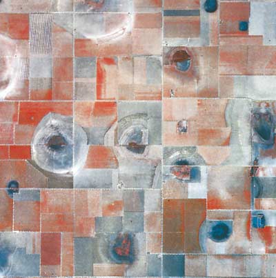
Generally, winds on Earth can move only sand and dust-sized particles, so deflation leaves concentrations of coarser material called lag deposits or desert pavements. Such residues may ultimately accumulate into sheets of coarse angular fragments that essentially cover the surfaces, protecting the finer material beneath from further erosion (Figure 8.45), and look like the surface of Mars.
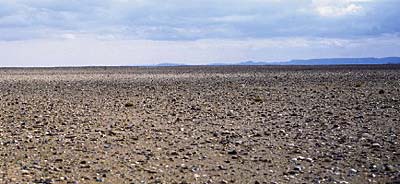
In areas where soft, poorly consolidated rock is exposed, small-scale features produced by wind erosion can be both spectacular and distinctive. Wind abrasion is essentially the same process as the artificial sandblasting used to clean building stone. The most common large-scale feature eroded by the wind are elongate yardangs like those found on Mars. On Earth, yardangs are usually less than 10 m high and are aligned parallel to the prevailing wind. They tend to form in groups in which the individual ridges are separated by smooth, wind-eroded troughs (Figure 8.46).
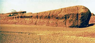
Large landforms produced by eolian erosion are rare on Earth. The most common features formed by wind abrasion are pebbles shaped and polished by the wind. Such pebbles are commonly distinguished by two or more smooth, polished surfaces that meet in a sharp ridge; these, too, are found on Mars.
Wind Deposition. Samples taken from many parts of Earth show that large quantities of small dust particles are transported great distances by wind. For example, some dust falls in the eastern United States were composed of particles that originated 3200 km to the west, in Texas and Oklahoma. Dust storms are major processes in Earth's deserts, although not of global scale like the martian storms. Great terrestrial dust storms sometimes reach elevations of 2500 m and advance at speeds of up to 200 m per second.
On Earth, great quantities of wind-blown dust transported from deserts and glaciated areas are eventually deposited as vast sheets that may mask preexisting landforms. Such loess deposits may exceed hundreds of meters in thickness, but most blankets of loess are much thinner. Loess covers about one-tenth of Earth's land surface. An estimated 500 million tons of windblown dust are carried from Earth's deserts each year. (This is only slightly less than the amount of sediment deposited each year by the Mississippi River). Some dust is deposited on the continents downwind from deserts, such as in China (Figure 8.47), but dust from the Sahara, Australia, and South America is carried out to sea. Loess deposits are particularly widespread in semiarid regions along the margins of great deserts (Figure 8.48). The equatorial tropics and the areas formerly covered by continental glaciers are free of loess. Moreover, loess sheets are short-lived because they are easily stripped away by the relentless activity of running water.
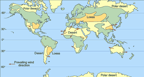
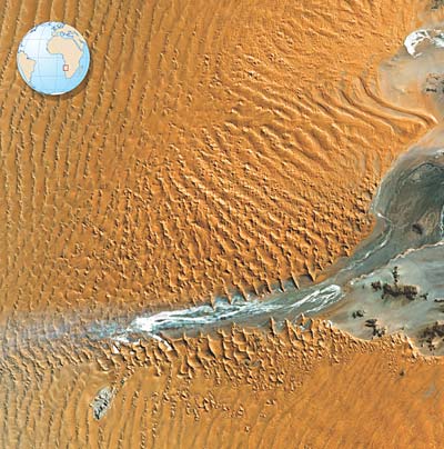
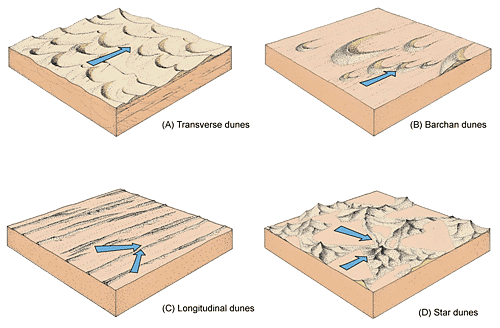
Types of sand dunes
(A) Transverse dunes
(B) Barchan dunes
(C) Longitudinal dunes
(D) Star dunes
As we saw on Mars, wind commonly deposits sand in the form of dunes, which generally migrate downwind. The existence of sand dunes on a planetary surface indicates that eolian processes operating on the planet have been or are capable of redistributing large quantities of sediment and resurfacing large regions of a planet.
The great sand seas of Earth are an effective resurfacing agent and vividly illustrate the dynamics of Earth's atmosphere. The dunes of terrestrial sand seas assume a variety of fascinating shapes and patterns, such as those shown in Figure 8.49. Longitudinal dunes are long parallel ridges of sand, elongate in the direction of prevailing wind. They occupy vast areas of central Australia, called the Sand Ridge Desert, and are well developed in the Sahara and Arabian regions as well. Transverse dunes have a wavelike form with the crust perpendicular to the prevailing wind. They typically develop where there is a large supply of sand and a constant wind direction. Where sand supply is limited, crescent-shaped dunes called barchan dunes tend to develop. Star dunes are mounds of sand having a high, central point from which 3 or 4 arms or ridges radiate in all directions. Strong winds and limited sand supply develop elongate sheets or stringers.
In Earth's polar regions, most of the water is in a solid state as ice and is not free to move rapidly in river systems. As a result the sculpting action of running water is subdued and ice takes over as the major geologic agent. If deposits of ice become thick enough they begin to deform and flow. As ice moves, it leaves its imprint in distinctive landforms not seen in the temperate, desert, or tropical regions of Earth. Viewed from space the importance of ice in Earth's geology is clear. During the winter in the northern hemisphere more than 50 percent of the land and up to 30 percent of the oceans may be covered by a blanket of snow and ice. Moreover, even in the present warm interglacial time, about one-tenth of the land surface (Antarctica and Greenland) is covered with glaciers. At times in the very recent geologic past (the Ice Age), 30 percent of the surface of the land was covered with glaciers.
In the polar regions, ice occurs principally as (1) glaciers, (2) ground ice, and (3) sea ice. Each of these accumulations of ice originates in a different way and constitutes a separate dynamic system. Together they replace the river system as the major process operating on the surface in the polar regions.
Glaciers are flowing masses of solid ice that are found in the cold mountains and polar regions of Earth. No other inner planet has glaciers, but the ice-covered surfaces of the satellites of Jupiter, Saturn, and Uranus show evidence of glacial flow. Thus, it is important to understand the dynamics of ice and how ice responds to gravitational, impact, and isostatic stresses in the crusts of the planets.
Continental Glaciers. Two enormous glaciers of continental proportions exist today in the polar regions, covering nearly all of the land masses of Greenland and Antarctica. The Greenland glacier covers an area of about 2 million km2, nearly 80 percent of the island. Only a narrow fringe along the margins of Greenland is free from ice (Figure 8.49). The general shape of the enormous mass of ice is like that of a flattened drop of water on a table. The upper surface is typically smooth and featureless and the base is relatively flat. The Greenland glacier is over 3000 m thick in its central part, but it thins toward the margins. The zone of accumulation is in the central part of the island, where the ice sheet is nourished by snowstorms moving from west to east. The snowline lies from 50 to 250 km inland, so that an area of melting constitutes only a narrow belt along the glacial margins.
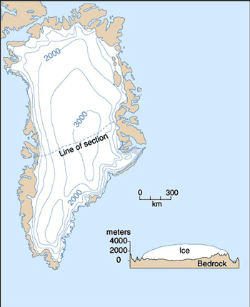
The glacier of Antarctica is much larger than that of Greenland and contains more than 90 percent of Earth's ice. Much of the glacier is over 3000 m thick, and the weight of this huge mass of ice has depressed a large part of the continent's surface below sea level. The thick ice covers nearly the entire continent and only small isolated areas of rock are exposed along the coast. The general contour of the Antarctic glacier is that of a very broad, low dome, so the surface is essentially an ice plateau sloping gently for about 4 km from the highest elevations near the center toward the coast.
Antarctica, like Greenland, is surrounded by water, so there is an ample source of moisture to continually feed the glacier. Evidence indicates that Antarctica has been completely covered with ice for more than 30 million years, the time since Antarctica drifted to its polar position.
The glaciers in Antarctica and Greenland provide enough data to construct conceptual models of how a glacial system functions. The basic elements of a continental glacier system and the landforms it produces are shown in Figure 8.50. Water enters the system as snow in a zone of accumulation and is transformed into ice by compaction. Adequate precipitation is essential for the growth and maintenance of a glacier. Cold temperature alone is not sufficient. A number of areas in Siberia are cold enough to support glaciers but have insufficient snowfall, hence glaciers do not develop. Under its own weight, the ice flows out from the zone of accumulation toward the margins, where it leaves the system through melting and evaporation. If more snow is added in the zone of accumulation than is lost by melting or evaporating at the end of the glacier, the ice mass increases in size, and the glacial system expands. If the accumulation of ice is less than is lost by melting and evaporation, there is a net loss of mass, and the size of the glacial system is reduced. If accumulation and loss are in balance, the mass of ice remains constant and the terminus of the ice remains stationary. Ice within the glacier, however, continually flows toward the terminal margins, whether these are advancing, retreating, or stationary.
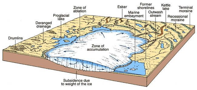
As shown in Figure 8.50, a continental glacier is a roughly circular or elliptical plate of ice, rarely more than 3000 m thick. Ice does not have the strength to support the weight of an appreciably thicker accumulation. If more ice is added by increased precipitation, the glacier simply flows out from the centers of accumulation more quickly. Because of the low gravity on Mars, much thicker accumulations of ice are necessary to initiate flow; such great thicknesses are not found even at the martian poles.
As glacial ice flows, it erodes, transports, and deposits vast amounts of rock material and greatly modifies the preexisting landscape. Glaciers erode bedrock (1) by glacial plucking and (2) by abrasion. Glacial plucking is the lifting out and removal of fragments of bedrock by a glacier. Beneath the glacier, meltwater seeps into fractures, where it freezes and expands, wedging blocks of rock loose. The loosened blocks freeze to the bottom of the glacier and are plucked or quarried from the bedrock, becoming incorporated into the moving ice. Abrasion is essentially a filing process. The angular blocks plucked by the moving ice freeze firmly into the glacier, and they act as tools that grind and scrape the bedrock. Aided by the pressure of the overlying ice, the angular blocks are very effective agents of erosion. The rock fragments are then carried suspended in the moving ice with large blocks transported side by side with small grains, without sorting or separation of the material according to size. As a result, the deposits of a glacier are unsorted and unstratified and thus differ markedly from stream deposits. Most of the particles transported by a glacier are deposited near the terminus, where melting dominates.
Glacial Landforms and the Ice Age. There is a wealth of undisputable evidence that only 15,000 to 20,000 years ago glaciers covered more than 30 percent of the land. Throughout most of Canada, Scandinavia, and parts of Russia, the surface is dominated by glacial landforms sculpted during the last ice age. During this time the normal hydrologic system was interrupted throughout large areas of the planet and was considerably modified elsewhere. The glaciated areas of Earth are among the youngest regional surfaces on the planet and record one of the most significant recent events in the history of Earth.
On a regional basis, the landforms produced by glaciation are spectacular. The moving ice eroded away several meters of soil and solid bedrock so that now many thousands of square kilometers of North America and northern Europe have little or no soil cover, and the effects of glaciation are seen everywhere in the polished and grooved surfaces of bare bedrock. The huge volume of soil and rock eroded by the glaciers was transported outward to the ice margins where it was deposited to form a series of ridges called terminal moraines, which mark the former position of the ice sheet (Figure 8.50). In places, the eroded material was shaped by the moving ice into swarms of stream-lined hills called drumlins (Figure 8.51). Much of the glacial sediment was reworked by meltwater and deposited in streams and lakes. These deposits range up to 300 m thick, so they commonly blanket the landscape upon which they rest.
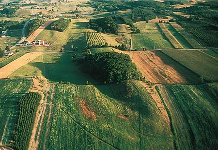
If a glacier expands beyond the shores of a continent, the ice will continue to move out to the sea as great plates of floating ice, known as ice shelves, but will still be attached to the land. Ice shelves are the largest floating masses of ice on Earth, averaging about 300 m thick. They commonly protrude 50 to 75 m above the water, and their surfaces are remarkably smooth and flat. The margins of the ice shelves typically form a line of vertical cliffs. Movement of the ice within the shelf is very rapid, on the order of 1000 to 1200 m per year. The shelf ice of Antarctica breaks off into enormous tabular icebergs characterized by flat tops and bases and nearly vertical sides. A single iceberg may be more than 15 km across and more than 600 m thick.
The presence of so much ice upon the continents had a profound effect on Earth's crust and its hydrologic system. Major isostatic adjustment of Earth's crust resulted from the weight of the ice, which depressed large areas of the continents. If the margin of the glacier is near the coast, an arm of the sea may invade the depression. In Canada, the entire region around Hudson Bay was depressed below sea level. In Europe, a similar depression was the area around the Baltic Sea. Ever since the ice melted, the land in these areas has been rebounding from these depressions and the former sea floor has risen almost 300 m. It is still rising at a rate of about 2 cm per year.
One of the most important effects of the ice age was the repeated worldwide fall and rise of sea level, corresponding to the repeated advance and retreat of glaciers. During a glacial period, water that normally returned to the ocean by runoff became locked upon the land as ice, and sea level was lowered. As the glaciers melted, sea level rose again. These fluctuations caused the Atlantic shoreline to recede between 100 and 200 km, so that vast areas of the continental shelf were exposed.
Another major effect of glaciation was the modification of regional drainage patterns. Prior to glaciation, the landscape of North America was eroded mainly by running water. Much of North America was drained by rivers flowing northward across Canada and into the Atlantic Ocean, because the regional slope throughout the north central part of the continent is and was to the northeast. As the glaciers spread over the northern part of the continent, they effectively buried the trunk streams of the major drainage systems, damming up the northward-flowing tributaries along the ice front. This damming created a series of lakes along the glacial margins. As the lakes overflowed, the water drained along the ice front and established the present course of the Missouri and Ohio rivers.
Another significant and obvious effect of glaciation was the formation of a myriad of lakes. Indeed, glaciation created more lakes than those produced by all other geologic processes combined. The reason is obvious if we recall that a continental glacier completely disrupts the preglacial drainage system. The surface over which the glacier moved was scoured and eroded by the ice, which left innumerable closed, undrained depressions in the bedrock. These depressions filled with water and became lakes.
Glacial Dams and Catastrophic Flooding: The Channeled Scablands. The continental glacier in western North America moved southward from Canada only a short distance into the state of Washington, but it played an important role in producing a complex of interlaced deep channels found there. These Channeled Scablands cover much of eastern Washington and consist of a network of braided channels from 15 to 30 m deep. The term scabland is appropriately descriptive because, viewed from space, the surface of the area has the appearance of great wounds or scars (Figure 8.52). Many of the channels have steep walls and dry waterfalls or cataracts. In addition, there are deposits with giant ripple marks and huge bars of sand and gravel. These features attest to an exceptional degree of erosion by running water, one that would be considered catastrophic by normal standards. Yet, today, there is not enough rainfall in the area to maintain a single permanent stream.
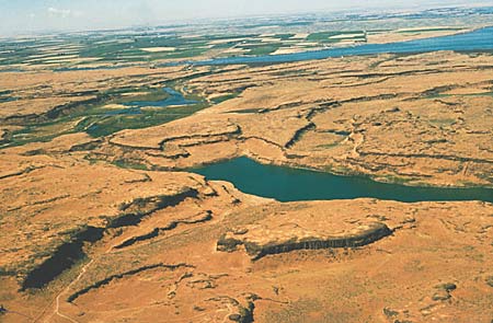
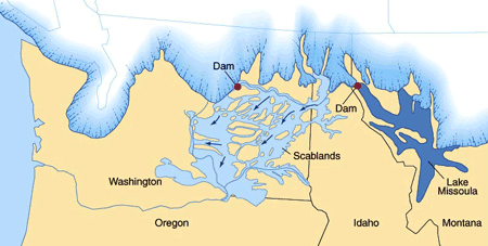
The ice sheet in northern Washington blocked the drainage of the northward-flowing Clark Fork River to form Lake Missoula, a long, deep lake in northern Idaho and western Montana. As the glacier receded, the ice dam that formed Lake Missoula failed catastrophically, and water from the lake quickly drained across the scablands, eroding deep channels. Repeated advance and retreat of the glacier probably produced several ice dams that failed as the ice melted, and each caused catastrophic flooding.
Briefly, the scablands were eroded by the following process. A large lobe of ice advanced southward across the Columbia Plateau and temporarily blocked the Clark Fork River, one of the major northward-flowing tributaries of the Columbia River (Figure 8.53). The impounded water backed up to form a long, narrow lake extending diagonally across part of western Montana called Lake Missoula. As the glacier receded, the ice dam failed, releasing a tremendous flood over the Columbia Plateau. The enormous discharge spread over the basalt surface, scouring out channels and forming giant ripple marks, bars, and other sediment deposits. Estimates suggest that during the flood as much as 40 km3 of water per hour might have discharged from Lake Missoula. Since glaciers advanced several times into the region, catastrophic flooding occurred many times.
In the polar regions groundwater is permanently frozen to a depth ranging from a meter or so to several hundred meters below the surface. This ground ice exists in the pore space between soil and rock particles as distinct lenses, veins, or wedges. The expansion, contraction, and partial melting of the ground ice produces some unique and spectacular landforms in the subarctic and arctic regions of Earth.
The permanently frozen ground is usually referred to as permafrost. It develops where the average annual temperature is 0 C (273 K) or below. When this happens, frozen groundwater penetrates deeper than the summer thaw does. The thickness of the permafrost zone, however, is limited, because the temperature within Earth rises on the average of 1 K for each 30 m; ultimately, temperatures above freezing are reached. Ground ice may, however, extend to formidable depths, from between 250 and 350 m in North America to a maximum of approximately 1500 m in Siberia. At the present time, ground ice underlies approximately 26 percent of Earth's land surface, so it is a significant factor in developing the features of the polar regions.
A variety of landforms are produced in permafrost areas, depending upon the surface material, slope, and the thermal conditions in the near-surface layer. The surfaces of permafrost areas often display distinct geometric shapes collectively referred to as patterned ground (Figure 8.54). One distinctive type of patterned ground, which looks like a smaller version of the polygonal cracks found on Mars, is marked by polygons that may range from a few centimeters to more than 100 m across. Although their origin is complex, cracking of the surface is instrumental in their development. During exceptionally cold winters the ground ice contracts because of thermal shrinking and cracks are thus formed that divide the ground surface into roughly equidimensional cells, much like the shrinking of drying mud produces mud cracks. During the summer thaw, water seeps into the cracks, subsequently freezes, and forms vertical veins or wedges of ice. Repetition of the process over many centuries produces a network of ice wedges and an unmistakable ground pattern.
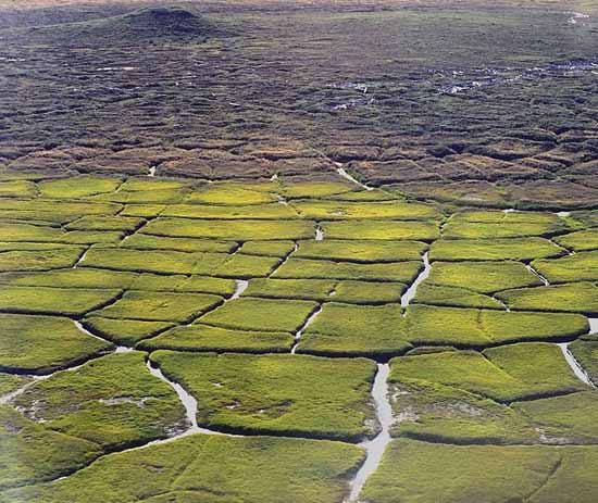
Melting of the ground ice and the migration of the meltwater commonly produces shallow irregular depressions called thermokarst. These features are similar in many respects to the sinkholes in normal karst regions, but the fundamental process is melting of ground ice rather than solution of rock material. Features interpreted to result from thermokarst are also abundant on Mars.
In addition to glaciers and permafrost, the polar regions are unique in that the seas are presently covered with sea ice (Figure 8.55). Sea ice is formed by the freezing of seawater and is distinct from the ice in ice shelves and icebergs, which are floating masses of glacial ice formed on land and transported to the ocean. The thickness of floating sea ice is limited to only about 3 to 4 m because the ice acts as an insulating layer, preventing the loss of heat from the water below that is necessary for the deeper water to freeze. Beyond a given thickness, the rate at which ice forms at the base of the plate of sea ice equals the rate at which ice is lost by melting and evaporation at the upper surface. Compared with the huge volumes of ice in the glaciers of Antarctica and Greenland, the thin veneer of sea ice may seem trivial, but its large areal extent has great importance on the heat exchange between the oceans and the atmosphere. Sea ice constitutes our best terrestrial example of the ice dynamics that operate on the icy satellites of the outer planets.
The sea ice is dynamic because it is subject to the force of waves, winds, currents, and tides, and breaks up into fragments which move about. The individual fragments may be forced together with such great pressure that the ice margins buckle to form pressure ridges and rough hummocky surfaces; they are commonly subjected to tensional forces that cause them to split apart along fracture systems. Water rapidly moves up into the fracture to freeze and form a younger generation of ice. This movement is reflected in the complex fracture systems and multiple generations of ice which fill the cracks (Figure 8.55).
The rocks that make up Earth are a record of events. They record the interaction of energy and matter with the passage of time and tell us of the major processes that shaped the planet. From the principles of superposition, radiometric dating, and the fact that the terrestrial biosphere changes with time, it has been possible to establish a relative, as well as an absolute, time scale for Earth. Most of the original time scale was pieced together from sequences of rocks and fossils studied in Europe during the mid-nineteenth century.
Major units of geologic time were generally named after a distinctive characteristic of the time period they represent or of a geographic area where rocks of that age are well exposed. The standard geologic column for Earth is shown in Figure 8.56. The column provides a framework for understanding the great tapestry of events that is the history of Earth.
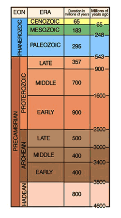
Four main subdivisions of Earth history can be defined.
1. Accretion (4.6 billion years ago) and internal differentiation accompanied a period of intense meteorite bombardment, perhaps including a giant impact with a body the size of Mars (Figure 8.57). No rocks are preserved unmodified from this stage (4.5 to 3.8 billion years ago).
2. Development of continental nuclei and the origin of life (3.8 to 2.5 billion years ago).
3. Stabilization of continental platforms and the oxidation of the atmosphere (2.5 to 0.6 billion years ago).
4. The modern plate tectonic period, typified by the fragmentation and construction of continents and the growth and destruction of ocean basins, as well as the expansion of life on land (0.6 billion years ago to present).
The evolution of Earth is summarized in Figure 8.58, which shows the thermal history of Earth. Figure 8.59 shows how the surface of Earth may have looked during the periods of time described below.
The Hadean Eon (4.6 to 3.8 Billion Years Ago). Earth, like the other inner planets, formed by the gravitational accretion of solid planetesimals that condensed from a gaseous nebula centered on the Sun. The accretion of millions of planetesimals a kilometer or so across occurred in a surprisingly short period by geologic standards, probably less than 100 million years.
The young Earth was probably relatively homogeneous; however, it was much hotter than it is today because of accretionary and radioactive heating. High internal temperatures, which had a profound effect on the future of Earth, resulted. By the time the growing Earth was about half its present diameter, it must have become hot enough for iron compounds to melt and form dense blobs that percolated down toward the interior of the planet to create a spherical metallic core. As a result, less dense silicates were displaced upward.
This rearrangement or differentiation of the interior also released further heat, adding to the effects of accretion and radioactive decay. By this time much of the outer part of Earth must have been partially molten, perhaps forming a globe-encircling ocean of magma. Differentiation of Earth continued as gases escaped from the interior to form an atmosphere of carbon dioxide, water, and nitrogen, similar in composition, if not bulk, to that of Mars and Venus. Eventually a cool crust formed on the upper surface of the magma ocean. Its composition was probably basaltic---that is, rich in iron and magnesium silicates and plagioclase feldspar. Simultaneously, the lower part of the magma ocean crystallized from its base upwards, forming a mantle rich in olivine or other magnesium silicates.
Sometime during this early accretion-differentiation episode Earth may have collided with a Mars-sized object (figure 8.57). Upon impact, the temperature, as high as 6000 K, created by the conversion of kinetic energy to heat would have vaporized much of Earth's crust and mantle. Moreover, a large crater penetrating nearly to the core may have formed. Most of the rock excavated materials temporarily thrown into space would fall back into the crater within a few minutes, but much of the vaporized material may have recondensed in orbit to form volatile-poor solids. Eventually, the Moon may have formed from this debris by a secondary accretion process. Iron from the core of the impacting body may have plunged rapidly through Earth's mantle adding to the mass of the growing core. If a giant impact occurred, most of the outer part of the Earth must have melted to form a magma ocean, even if one had not formed earlier. Consequently, if any atmosphere remained after the impact it must have boiled away at this point.
Earth's early crust was probably very different from modern continental crust but no trace of this primordial crust has been preserved. In fact, the oldest rocks so far found on Earth are "only" 3.8 billion years old. A crust of anorthosite like that which formed on the Moon probably did not form on Earth because plagioclase will not float in basaltic magma that contains a small amount of water. Magmas on the more volatile-rich Earth almost certainly were "wet" as compared to those on the Moon.
This period of time unrecorded by any existing rocks is called the Hadean Eon after the mythical fiery home of the dead---Hades---an appropriate name for this the hottest stage of Earth's evolution. Earth must have experienced a period of intense meteoritic bombardment during the first half-billion years of its history. This epoch of meteorite impact is clearly recorded on the surfaces of the Moon, Mercury, and Mars. In all probability the surface of the young Earth appeared much like that of the Moon (Figure 8.59). The impact of small and large bodies probably created a densely cratered terrain over the entire planet.
This cratered surface was probably short-lived, however. Earth's early lithosphere was probably thin and its interior vigorously convecting, so that any piece of solid crust formed was shortly swallowed back into the mantle. Large impacts, like those that formed the basins on the Moon, almost certainly penetrated Earth's thin crust and promoted this recycling and churning process. It may be no coincidence that the oldest rocks preserved at the surface of Earth (3.8 billion years old) formed shortly after the rapid decline of the bombardment rate discovered on the Moon (3.9 billion years ago). Before the decline in bombardment, the crust could not become stabilized at the surface.
The Archean Eon (3.8 to 2.5 Billion Years Ago). One of the most significant features of Earth is the presence of distinctive continental highlands whose origins can be traced back to about 3.8 billion years ago. Only small fragments of deformed and metamorphosed rocks are this old, but they demonstrate that light silicates developed and began to accumulate to form the continental crust by at least 700 million years after the accretion of Earth. The oldest rocks on Earth include metamorphosed sedimentary rocks, demonstrating that Earth had cooled enough so that liquid water existed on the surface of the planet by at least 3.8 billion years ago; in fact, the condensation of liquid water may have been much earlier than this. The oceans that now cover so much of Earth were derived from water vapor in the atmosphere after it had cooled sufficiently to allow water to condense and rain to fall. The removal of water vapor from the atmosphere greatly reduced the pressure of the atmosphere, as well as its capacity to cause greenhouse warming. Over time, depressions (probably impact basins) filled with water, the first oceans began to take form, and a dynamic hydrologic system of rivers and oceans was fully established.
In these oceans, life evolved by about 3.5 billion years ago. Evidence of simple one-celled organisms is found nearly from the beginning of the rock record. Oxygen was produced by these primitive plants and as a result a protective ozone (O3) layer began to form by the action of sunlight on oxygen in the upper atmosphere.
The terranes preserved from this period consist of metamorphosed accumulations of mafic lavas (greenstones) pierced and deformed by slightly younger granite plutons. Distinctive members of these ancient terranes are magnesium-rich lavas erupted at very high temperatures---an indication of the higher temperature of Earth during its early history. Earth has cooled by about 300 K during the last 3 billion years of its history (Figure 8.59). These ancient granite-greenstone terranes may have become stabilized at the surface by the presence of the low density granites. However, most crust formed during the Archean was recycled back into the mantle by vertical sinking or by incipient plate tectonics.
Perhaps the most important development in this stage of Earth history was the tremendous growth of continental crust during the latter part of this epoch. Between 3.0 and 2.6 billion years ago, 50 to 90 percent of the present volume of continental crust formed. Rocks of this age form Earth's shields and underlie the thin sedimentary veneer of the platforms. The mechanisms by which this low-density silicon- and aluminum-rich crust developed are still uncertain. The granitic portion of the continental crust may have formed as silica-rich magma was produced from basaltic crust. It is speculated that the primitive basaltic crust may have warped down into the warmer interior of Earth by the loading of younger volcanic rocks on its surface above a mantle plume or by down buckling above a mantle cold spot (Figures 8.59 and 8.60). The deep basaltic crust would have heated as it was forced to greater depths and perhaps melted to form granite that rose and intruded overlying greenstones creating the composite granite-greenstone terrains. Such a sequence is similar to the hypothesis developed for the origin of highland plateaus presently found on Venus. Others suggest that the silicic magmas that created the ancient continental crust were produced in modern-style subduction zones as lithospheric slabs were thrust into the planet's warm mantle. In any case, tremendous volumes of light, more silica-rich rocks were produced by reworking of older crustal material and accumulated to form protocontinents. These continents and the lithosphere that contained them were probably thin compared to present-day continents.
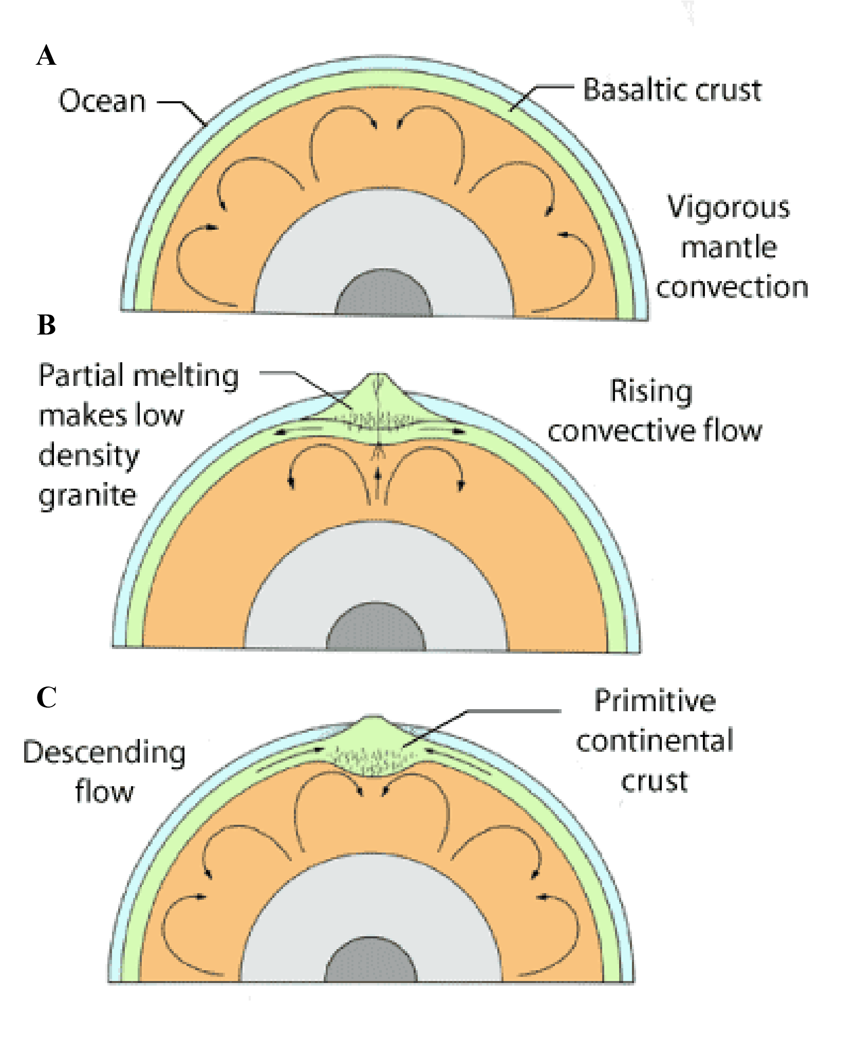
The presence of ancient metamorphosed sedimentary rocks clearly indicates that the temperature range at the surface of Earth from 3.8 billion years ago to the present was roughly constant. The temperature permitted water to exist in a liquid state. Earth was not hot enough for its oceans to evaporate (like Venus) or cold enough for them to freeze (like the satellites in the outer solar system). This nearly constant temperature range on Earth's surface is indeed a remarkable fact.
The great amount of geologic activity during this period, driven by the heat in the mantle, distinguishes Earth from the other planets. For example the Moon's crust had long before become stabilized and its lithosphere thick and only the mare lavas were erupted during this period.
The Proterozoic Eon (2.5 to 0.6 Billion Years Ago). A dramatic change in the character and behavior of the continents occurred about 2.5 billion years ago, shortly after the period of major crustal growth. Unstable, short-lived, mafic Archean crust was transformed into the stable, long-lived, more granitic crust typical of the Proterozoic and subsequent ages. By the beginning of this stage the continents, although not in their present shape or distribution, had roughly their present volume, thickness, and stability against recycling back into the mantle.
This transition is marked by a significant increase in the abundance of carbonate--sandstone--shale sedimentary rocks that are typical of modern continental margins covered by shallow seas. Most modern platforms are veneered by similar, but undeformed, rocks. Accumulations of sedimentary rocks of this age range up to about 10 km thick; similar thicknesses are found in modern environments, as for example on the rifted margins of continents.
The first well-defined continental rifts also appear to have developed at this time and indicate the crust was brittle, relatively thick, and probably cooler than in the earlier Archean Eon. During the Proterozoic, large fault-bounded rifts formed and filled with sediments and volcanic rocks. These troughs are similar in many respects to the failed arms of rifts found on the present continents. These rifts may be key features indicating the existence of modern-style plate tectonics by about 2 billion years ago. Many abortive attempts at continental rifting occurred and left vast dike swarms and linear belts of distinctive complexes of mafic and granitic rocks.
These important changes may reflect differences in the energy content of Earth as it cooled and may be related to a thicker and stronger lithosphere, as well as a more coherent layer of continental crust. In spite of a near constant atmospheric temperature, the interior of Earth appears to have cooled about 100 K for each billion years of its early history. Lithospheric thickness probably changed in a complementary fashion, with the Hadean lithosphere perhaps only 10 to 20 km in thickness, increasing to perhaps 25 to 40 km thick by the early Proterozoic. As Earth's lithosphere became thicker and more rigid over large distances, tectonic plates became defined. Subduction of these plates back into the mantle must have begun when old, cold lithosphere became dense enough to fragment and sink back into the mantle, pulling the rest of the plate with it down a newly defined subduction zone and corresponding trench. The density difference between thin, young lithosphere and old, thick lithosphere is an important driving force for plate tectonics, one amplified by metamorphic changes that create denser minerals in the subducting slab. Segments of the lithosphere rich in low-density rocks like granite were not only high-standing but nearly impervious to subduction. Thus, the transition from the Archean to the Proterozoic marked a fundamental threshold in Earth's history and led to the development of modern crustal conditions and plate tectonics.
Earth's atmosphere was created by volcanic activity but changed in response to the evolution of the biosphere and changes on the continents. Vast amounts of carbon dioxide were probably removed during this or an earlier time and trapped in the limestones preserved on the continents. If all the carbon dioxide in carbonate rocks were released to the atmosphere, it would exert a pressure about 50 times greater than the pressure of today's atmosphere. Increasingly complex forms of oxygen-producing life developed during the Proterozoic, and consequently the level of free oxygen in the atmosphere increased. As a result of the buildup of oxygen, the iron dissolved in the oceans precipitated in shallow basins on the margins of continents to make delicately banded deposits of oxidized iron.
The Phanerozoic Eon (0.6 Billion Years to Present). The tectonic and hydrologic systems continued to operate, resulting in slowly enlarging continental mass and the growth and destruction of ocean basins. Each continental shield was eroded to near sea level and was in gravitational equilibrium. As the continents drifted with the lithospheric plates, slight changes in sea level permitted shallow seas to expand over the shields, and extensive layers of horizontal sedimentary rocks were deposited on the continents to form the stable platforms. These rocks contain abundant fossils, which record a dramatic diversification of life after about 600 million years ago. All major groups of animals are represented in these rocks, although marine invertebrates dominate. These fossils also reveal changes in local temperatures and geographic settings that correspond to plate movements through the various climate zones on Earth. By about 300 million years ago, plate tectonics developed a huge supercontinent, called Pangaea, "one earth" (Figure 8.61). The southern continents were grouped near the south pole, where glaciation occurred. North America and Europe were in the equatorial zones where lush swamps flourished that later developed into extensive coal deposits.
The history of Earth during the last 300 million years is known in much greater detail than that of the earlier Earth; by combining a variety of geologic evidence from various continents and ocean basins, we are able to reconstruct the sequence of events that resulted in the breakup of Pangaea and the development of the present continents and ocean basins. The results of this synthesis are shown in Figure 8.61. The initial event was the splitting of the continents along a north south rift above a mantle plume. The fractures that formed enlarged to form a rift that became an oceanic ridge in the Atlantic Ocean. Africa and India moved northward and collided with Europe and Asia to form the Alps and Himalaya mountains. The westward drift of North and South America over the Pacific plate and resulting collisions with small island arcs and other far-travelled fragments resulted in the growth of the continents' western portions and produced the Sierra Nevada, Rocky, and Andes mountain chains, which have strongly deformed sedimentary and metamorphic rocks intruded by igneous rocks.

(A) Pangaea, 200 million years ago. Red lines indicate divergent plate boundaries and blue lines represent convergent boundaries.
(B) Plate movement 100 to 50 million years ago. The Atlantic Ocean basin formed as North and South America drifted westward. The Tethys Sea between Asia and Africa is nearly closed.
(C) Plate configuration today.
During this stage of Earth's history, significant changes occurred in the animal and plant communities. The periodic extinctions of many forms of land and marine life that occurred over relatively short periods of time have been used to subdivide Earth's geologic history. For example, dinosaurs flourished from about 200 million years ago and became extinct about 65 million years ago. Mammals then became the dominant animals on land. As noted earlier, some geologists relate the demise of dinosaurs and other forms of plant and animal life to rapid changes in climate induced by a meteorite impact known to have occurred at this time. However, many others think the impact and the extinctions are merely contemporaneous events and not related in a cause-and-effect fashion. Evidence of meteorite or comet impact has not been found at all horizons in the rock record where mass extinctions are known to have occurred.
While the continents drifted toward their present positions they set the stage for the most recent major event in geologic history, the ice age. Antarctica drifted over the south pole possibly as long as 30 million years ago, and has been in a deep freeze ever since. The northern continents, however, form a patchwork of land and sea around the north pole, and climatic conditions controlled by orbital parameters and changing oceanic currents and atmospheric composition fluctuated to produce a series of four major glacial and interglacial epochs (Figure 8.62). During the ice age, the hydrologic system was interrupted significantly. Much of the precipitation on the land, which normally returned directly to the sea, became trapped on the continents as glacial ice. Consequently, sea level dropped as much as 100 m over the entire globe. The moving ice scoured the landscape, forced the crust to subside under its weight, and created a myriad of lakes. The area beneath the ice was completely depopulated of all life, and both plant and animal communities were forced to migrate before the changing margins of the ice sheets.
The grand central theme of Earth's history is change---constant and sometimes rapid change resulting from the great energy sources of internal heat and solar radiation. Driven by the planet's attempt to rid itself of the heat within, the tectonic system of Earth has continued uninterrupted from the beginning. The style of lithospheric recycling may have changed but the system has continued to operate. Unlike the Moon, Mercury, and Mars, Earth has been resurfaced millions of times; ocean basins have been created and destroyed; continents have grown, drifted together, and rifted apart. Erosion, accomplished by the gravity-driven flow of surface fluids (water, wind, and ice), constantly renewed Earth's surface, and volcanism has been vigorous and long-lived. These factors make Earth unique among the planets, but much more similar to Venus than to any of the others. The Moon, Mercury, Mars, and the satellites of the outer planets have experienced only the initial stages of a tectonic system; throughout most of their histories they have remained much as they were soon after the creation of the solar system. The larger size of Earth and its substantially slower cooling rate produced many of its distinctive characteristics. Geologic processes on these other objects do not approach the dynamic activity of Earth's volcano-tectonic system. No other planet supports a liquid ocean of water or an atmosphere rich in oxygen. And, perhaps most important, no other planet is known to harbor life.
1. In light of Earth's vigorous interior and high internal temperatures, why are the volcanoes on Mars so much larger than those found on Earth?
2. Where did the free oxygen in Earth's atmosphere come from? Why are the atmospheres of Mars and Venus carbon-dioxide-rich and oxygen-poor? What happened to the carbon dioxide that once resided in Earth's atmosphere?
3. What are the major differences between the crust of Earth and the crust of the Moon? What events or processes caused this dramatic difference in crustal properties?
4. What are the major differences between the crust of the continents and the crust of the ocean basins?
5. Compare Earth's hydrologic cycle (using diagrams) with that found on Mars. What is the major source of energy for this system?
6. How did the oceans form on Earth? What changes have occurred in the ocean during Earth's history?
7. How does a river system grow longer?
8. Describe the important elements of a typical terrestrial river system. How do these compare with the channels found on Mars?
9. How do springs originate? Are they important erosion agents on Earth's continents?
10. Compare the glacial ice caps found on Earth with the ice caps of Mars in terms of their composition, age, erosive power, and variability.
11. Has sea level remained constant through the history of Earth? What causes sea level changes? How does a continent change with sea level rise, with sea level drop?
12. Give an example of a flowing solid at the surface of Earth. Do you think the movement of this material may be important on any other worlds in the solar system?
13. What controls the distribution of the major deserts of Earth?
14. What evidence is there that Earth's crust and lithosphere are in motion?
15. Describe with sketches the fundamentals of Earth's tectonic system. What is the major source of energy for this system?
16. How is the type of volcanism on Earth related to the tectonic setting of the volcano?
17. What is the origin of the linear chains of volcanic islands found on the ocean floor? How would volcanic activity differ if a mantle hot spot were active on Mars?
18. Explain convection in Earth's interior. Is the mantle necessarily liquid?
19. In what ways are the rocks of Earth's oceanic crust similar to those of the lunar maria?
20. Why are the oldest rocks on Earth found on its continents?
21. Why did continents develop on Earth and not on the Moon, Mercury, or Mars?
22. Explain why the oldest rocks found on the Moon are about 700 million years older than those found on Earth.
23. Draw a sketch of the interior structure of Earth and briefly discuss the core, mantle, asthenosphere, lithosphere, and crust. At what stage of Earth's history did its layered structure develop?
24. Is it plausible to think that meteorite impact has shaped not only the physical evolution of Earth but its biological evolution as well?
abrasion
alluvial fan
ash fall
ash flow
ash-flow shield
batholith
braided river
composite volcano
continents
continental glacier
continental rift
convergent boundary
delta
desert
divergent boundary
flood plain
folded mountains
granite
glacial dam
ice age
ice shelves
island arc
isostasy
karst
magnetosphere
ocean
oceanic ridge
ocean basins
Pangaea
patterned ground
permafrost
plate tectonics
plucking
river
sea ice
seamount
shoreline
shield
sinkhole
stable platform
stream valley
strike-slip fault
subduction zone
thermokarst
tidal force
transform boundary
transform fault
trench
valley glacier
weathering
Christiansen, E. H., and Hambline, W.K., 2015. Dynamic Earth, Jones-Bartlett Publishers.